Itryatgolf
Member
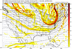
Basically fun to look at imagesCan someone explain what this means iv never understood this map.
Basically fun to look at imagesCan someone explain what this means iv never understood this map.
Blue purple pink means you might have winter Grey and white mean winter cancelCan someone explain what this means iv never understood this map.
You might be joking but that’s basically factsBlue purple pink means you might have winter Grey and white mean winter cancel
You are correct. Even that great 2009-2010 winter had that mild 2 week period in the middle of January before that great pattern set up late in the month and for most of February.You can sorta see that typical mid january warm up(el nino canon) in the way that the departures from normal start rising toward mid month on the weeklies and the GEFS extended.
It's nothing to panic about. Mid January thaws are pretty typical. Right now, I think I wouldnt be shocked to see some -4 or -5 departures from Christmas to close to King day.
2002-2003 as well.You are correct. Even that great 2009-2010 winter had that mild 2 week period in the middle of January before that great pattern set up late in the month and for most of February.
The Euro is projecting snowfall totals over the next 45 days. It looks way overdone.Can someone explain what this means iv never understood this map.
Of course, if this SSW breaks in our favor, this is all very subject to change.You can sorta see that typical mid january warm up(el nino canon) in the way that the departures from normal start rising toward mid month on the weeklies and the GEFS extended. One thing I have noticed is the weeklies want to nearly tank the EPO while GEFS extended isnt showing that.
It's nothing to panic about. Mid January thaws are pretty typical. Right now, I think I wouldnt be shocked to see some -4 or -5 departures from Christmas to close to King day.
Do you see any “true” cold air coming in January and February?I'm having a real hard time seeing anything significant wintry weather outside the mountains prior to January. Even though we may have a +PNA of some sort initially and deep-layer temperatures may be below average, there honestly isn't a ton of true cold air around that's needed to deliver a big winter storm for the board, at least through basically the rest of this month. A few models have tried to hint at a glancing blow of colder air before the +EAMT induced jet extension takes over, but I don't really buy it yet (when it comes to snow).
We're going to need the Alaskan Vortex to begin backing away towards the Aleutians before some real cold air starts getting dumped into the CONUS.
Heading into the Holidays, I'm much more concerned about severe weather, especially for the Deep South & Gulf Coast states.
It can also be pointed out that the MJO doesn’t really favor anything in the next couple weeks either. It’s running through phases 4-7. It is going low amp and possibly into the COD which should prevent an all out extended torch. The good news is that it’s hitting phase 8 late in the month when many of us can score in a marginal set up.I'm having a real hard time seeing anything significant wintry weather outside the mountains prior to January. Even though we may have a +PNA of some sort initially and deep-layer temperatures may be below average, there honestly isn't a ton of true cold air around that's needed to deliver a big winter storm for the board, at least through basically the rest of this month. A few models have tried to hint at a glancing blow of colder air before the +EAMT induced jet extension takes over, but I don't really buy it yet (when it comes to snow).
We're going to need the Alaskan Vortex to begin backing away towards the Aleutians before some real cold air starts getting dumped into the CONUS.
Heading into the Holidays, I'm much more concerned about severe weather, especially for the Deep South & Gulf Coast states.


GFS had quite a pattern toward the end of the run.GEFS run had one member with 3-4 ft of snow from one storm. I had a hard time not posting it. Forgive me


Yeah, it’ll go to Asia and Europe first and be over here in April, after a SSWDo you see any “true” cold air coming in January and February?
That member had 16” in about as many hoursGEFS run had one member with 3-4 ft of snow from one storm. I had a hard time not posting it. Forgive me


Like the blocking over the top to suppress the flow in the east, the ridging over AK to inject legit cold into the pattern, and the active STJ. Looks good.GEFS Ext 7-day average for Jan 3 - Jan 10. Very tasty if true
Above normal AK, always a good sign!Same, but temperatures
 ️
️And right in this time frame the rumblings about the elusive SSWE perhaps kick in to make the rest of prime-climo very interesting.GEFS Ext 7-day average for Jan 3 - Jan 10. Very tasty if true

Continuing to see hype about the Christmas timeframe here. This has been a consistent theme for a few weeks now
I'll believe it when I see it... I'm not even talking about cold the rain has mostly dried up even which is more disturbing to me. Everything in fantasy land that has looked promising goes poof so far
Yeah. Think it be very end December into January we start to scoreBeen like that for years now. I would be surprised if we get the rug pulled out from under us again.
Sent from my iPhone using Tapatalk

Thanks grit. Looks to be in the -3 C range. What are our (NC) average 850 temps (F) in that time frame?Same, but temperatures
Charlotte is about 2 to 3 degrees Celsius at 850 mb, on average this time of year. So most of NC would average below 0, if that map is correct.Thanks grit. Looks to be in the -3 C range. What are our (NC) average 850 temps (F) in that time frame?
Thanks. That's what I figured. That scenario w/o suppression and we stand a decent chance to get a hit during this ninoCharlotte is about 2 to 3 degrees Celsius at 850 mb, on average this time of year. So most of NC would average below 0, if that map is correct.


Are you still expecting a flip to a pretty decent pattern beginning January?No wonder it's been so quiet in here the last several days.
If you were hoping to see some snow before January, I honestly can't think of a crappier pattern than this one.
Plenty cold enough for cold rain, but nowhere near cold enough to snow.
Not surprised at all though, this is pretty in line w/ what I was saying in here earlier this week & is par for the course for big El Niños.
View attachment 138418
View attachment 138419