Yeah the airport just missed double digits in 2013-2014, though most of the metro area had over 10”+.I didnt realize it but it's been twenty years since the CLT airport has had a double digit season.
-
Hello, please take a minute to check out our awesome content, contributed by the wonderful members of our community. We hope you'll add your own thoughts and opinions by making a free account!
You are using an out of date browser. It may not display this or other websites correctly.
You should upgrade or use an alternative browser.
You should upgrade or use an alternative browser.
Wintry Winter Discussion 2023/24
- Thread starter Rain Cold
- Start date
Itryatgolf
Member
I'm surprised you guys didn't reach it in Feb 2015, which was one of coldest February's in a long timeYeah the airport just missed double digits in 2013-2014, though most of the metro area had over 10”+.
- Joined
- Jan 23, 2021
- Messages
- 4,604
- Reaction score
- 15,203
- Location
- Lebanon Township, Durham County NC
I'm not saying I'd sell my soul for another 2002-2003 but you might get a finger out of meYeah the airport just missed double digits in 2013-2014, though most of the metro area had over 10”+.
tennessee storm
Member
Sometime more than not … bitter cold air don’t lead to more snow… but suppression city .I'm surprised you guys didn't reach it in Feb 2015, which was one of coldest February's in a long time
NoSnowATL
Member
Yes cold air is dry, You want low 30s vs low 20s. We like pancake flakes and no dandruff flakes.Sometime more than not … bitter cold air don’t lead to more snow… but suppression city .
Would gladly take 2002-2003 or 2003-04I'm not saying I'd sell my soul for another 2002-2003 but you might get a finger out of me
We got screwed by the warm nose in that late February storm and only ended up with 1-2” when 8–12” was forecastI'm surprised you guys didn't reach it in Feb 2015, which was one of coldest February's in a long time
Itryatgolf
Member
Lots of sleet then 1-2 inches ain't badWe got screwed by the warm nose in that late February storm and only ended up with 1-2” when 8–12” was forecast
- Joined
- Jan 23, 2021
- Messages
- 4,604
- Reaction score
- 15,203
- Location
- Lebanon Township, Durham County NC
Same in Fort Mill. I was living just around the corner from carowinds and that was the exact wrong spot to be. Swung between sleet and snow all night.We got screwed by the warm nose in that late February storm and only ended up with 1-2” when 8–12” was forecast
D
Deleted member 609
Guest
Pretty sure this was the one where every single gefs ensemble member had me getting over 8 inches 24 hours out. I think I got 8 snow flakes.Biggest screw job for Triangle was January 2017. Huge bust.
- Joined
- Jan 23, 2021
- Messages
- 4,604
- Reaction score
- 15,203
- Location
- Lebanon Township, Durham County NC
I had just moved to Davidson and it was like “wow, so this is how the other half lives”.Pretty sure this was the one where every single gefs ensemble member had me getting over 8 inches 24 hours out. I think I got 8 snow flakes.
Here in eastern Union County, it was the same with the ensembles. The NAM and HRRR both started picking up on that warm nose about 18-24 hours out. The worst part for me was that the Winter Storm Warning actually did verify for me because I ended up with over a .25” ice accumulation when ZR wasn’t even in the forecast. The 6-8” of snow that was forecast ended up being .5” on top of the icePretty sure this was the one where every single gefs ensemble member had me getting over 8 inches 24 hours out. I think I got 8 snow flakes.
Some of the heaviest rates I’ve ever seen were in this one in Jan 2017. It was 2-3 inch hour type rates a bit after midnight to 2 AM. Wind picked up and it started snowing hard with medium size flakes, then the wind died down and chicken feathers started dropping down. It was a sightI had just moved to Davidson and it was like “wow, so this is how the other half lives”.
LukeBarrette
im north of 90% of people on here so yeah
Meteorology Student
Member
2024 Supporter
2017-2023 Supporter


So close
- Joined
- Jan 23, 2021
- Messages
- 4,604
- Reaction score
- 15,203
- Location
- Lebanon Township, Durham County NC
Euro control was super close
I remember the snow starting at 3 in the afternoon and then continuing until dark before the changeover to sleet. The Weather Channel's futurecast expected a changeover to snow again, but it never happened. I got 5 inches in central Alamance, while the northern part of the county got 10... it was painful but not nearly as bad as what some folks experienced.Biggest screw job for Triangle was January 2017. Huge bust.
LukeBarrette
im north of 90% of people on here so yeah
Meteorology Student
Member
2024 Supporter
2017-2023 Supporter
I don’t see this system happening but with correct trends (a little stronger PNA with it a tad more west, stronger energy, etc.) things could happen.Euro control was super close
J1C1111
Member
I ended up with a solid 10 inches of snow out of the January 2017 storm and avoided the warm nose which is rare in this neck of the woods. 8/10 times you always get a warm nose or dry tongue. That was the 2nd best snowstorm around here in the last 10 years only behind Dec 2018 which dumped 11.5 inches but ended up with the warm nose early that morning and everything went over to sleet and freezing rain or would of easily ended of with another couple inches on top of the 11.5
If the Jan 18 storm hadn’t happened the year after, I think I’d be more scarred than I am about that one but WHEW boy that was an ugly ugly night on the boards for the Triangle properBiggest screw job for Triangle was January 2017. Huge bust.
Ron Burgundy
Member
I don’t usually remember other members’ posts, but I remember Brick’s that night. It reminded me of when Clark Griswald found out Wally World was closed.If the Jan 18 storm hadn’t happened the year after, I think I’d be more scarred than I am about that one but WHEW boy that was an ugly ugly night on the boards for the Triangle proper
- Joined
- Jan 23, 2021
- Messages
- 4,604
- Reaction score
- 15,203
- Location
- Lebanon Township, Durham County NC

NoSnowATL
Member
Lets Freakin GO!!

I sure hope the CFS is onto something. The period from around December 10th through January is my favorite time of year for winter weather. A much higher chance of prolonged cold with low sun angle and long nights to keep potential snow around longer than later in the winter. Not to mention the always hoped-for chances of a White Christmas.
Brent
Member
I'm still liking mid month here... And one of our mets predicted the first real snowfall then so I'm very curious to see if it pans out ? I'm not at all holding my breath but there has been a signal
The 0z CFS looks stellar once again mid month up until a couple days before Christmas. Then proceeds to wet the bed from there on out, horrific looking. Yesterdays runs where Golden. See if it changes its tune back latter today. As long as Grit and Fro are feeling optimistic Last week Dec into Jan for a favorable pattern, that is 100x more dependable than looking into the CFS magic 8 ball for clues. Plus the weeklies are still in our corner as well.
Tarheelwx
Member
I seem to remember that the level of optimism, weeklies, and other long range models this time last year had everyone pushing their chips to the middle of the table. Then over a period of 1-2 weeks, the wheels fell off and everything started getting pushed back and we ended up with a dumpster fire. Here’s to hoping Tuesday night’s CFS is correct and last night’s isn’t the beginning of a bad trend.
TW
TW
Honestly last December, the pattern really did develop the way the models were showing. It just simply didn’t deliver because everything ended up getting suppressed which is always a danger with cold periods in La Niña. Personally, I’m still not believing that the southeast scores outside of the mountains during December. The pattern looks to me like it’s more of cold snap followed by mild weather and repeat. Given that some people, including myself, were thinking that December was going to be an absolute blowtorch like 2015, that is looking like less and less of possibility everyday. Either way, I still think it will be just after the New Year, maybe just before if we’re lucky before pattern that could produce develops.I seem to remember that the level of optimism, weeklies, and other long range models this time last year had everyone pushing their chips to the middle of the table. Then over a period of 1-2 weeks, the wheels fell off and everything started getting pushed back and we ended up with a dumpster fire. Here’s to hoping Tuesday night’s CFS is correct and last night’s isn’t the beginning of a bad trend.
TW
Expanding high pressure in Siberia is usually a good first step toward getting it colder in our world in a few weeks

I also like seeing the low pressures to the east of Greenland allowing the high pressures to set up just to the west and keeping the -NAO west based.Expanding high pressure in Siberia is usually a good first step toward getting it colder in our world in a few weeks
Anyone here with knowledge of the QBO? Is this easterly weakening just a blip?
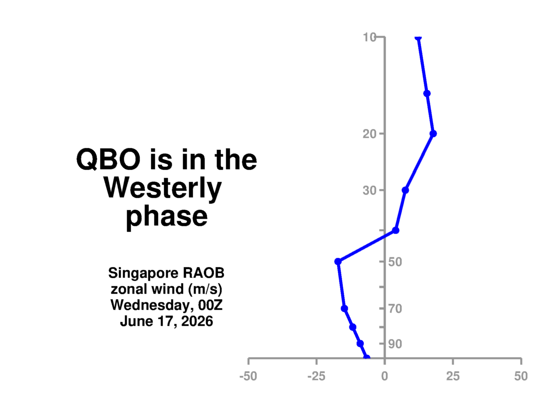
East qbo favors colder and more strat activityAnyone here with knowledge of the QBO? Is this easterly weakening just a blip?

Itryatgolf
Member
I see our famous analog 1976-77 lolEast qbo favors colder and more strat activityView attachment 138249
Meh, to my limited k owledge self, I e seen the cold build over there and just stay put all winter! It loves to just stay and fester on that side of the world and for whatever reason, is hard to get over hereExpanding high pressure in Siberia is usually a good first step toward getting it colder in our world in a few weeks
Yes. What I'm wondering is what if anything does the (temporary?) reversal to a westerly component as shown on the plot I posted mean for chances of a weakened or SSWE events?East qbo favors colder and more strat activityView attachment 138249
The key zone is 30mb down to 50mb. The QBO is in as good a position as it could possibly be. If we have troubles this winter, it won't be because of the QBO. The positive values below 50mb are from the previous positive QBO phase. That is, each phase decends thru the stratosphere (i.e. over time it works itself from higher up in the stratosphere, say 10mb, to lower, say 50mb). The positives starting to show up near 10mb is the next positive phase of the QBO that will descend as well...but it's a fairly slow processYes. What I'm wondering is what if anything does the (temporary?) reversal to a westerly component as shown on the plot I posted mean for chances of a weakened or SSWE events?
IMO it definitely doesn’t hurt to see that cold buildup over there, but I also never like to depend on it to get cold airmasses here. The only way that we see any of it is with a strong cross polar flow that has been few and far between in recent years. Even if we get one, we run the risk of suppression like last year around Christmas. I much rather put my hopes on snowpack and cold building up over NW Canada and the Alaskan north slope and then get a decent western ridge to push it southeastMeh, to my limited k owledge self, I e seen the cold build over there and just stay put all winter! It loves to just stay and fester on that side of the world and for whatever reason, is hard to get over here
Yeah the Siberian high tends to be part of the process that adds amplification into the pattern as momentum kicks off E Asia...and then in this case is supplemented with El Nino and the MJO working from the W Pac into the E Pac....and that amplification builds those ridges that are needed into AK and W CanadaIMO it definitely doesn’t hurt to see that cold buildup over there, but I also never like to depend on it to get cold airmasses here. The only way that we see any of it is with a strong cross polar flow that has been few and far between in recent years. Even if we get one, we run the risk of suppression like last year around Christmas. I much rather put my hopes on snowpack and cold building up over NW Canada and the Alaskan north slope and then get a decent western ridge to push it southeast
Itryatgolf
Member
You always want the Pacific on your side instead of just the Atlantic for colder weather imoIMO it definitely doesn’t hurt to see that cold buildup over there, but I also never like to depend on it to get cold airmasses here. The only way that we see any of it is with a strong cross polar flow that has been few and far between in recent years. Even if we get one, we run the risk of suppression like last year around Christmas. I much rather put my hopes on snowpack and cold building up over NW Canada and the Alaskan north slope and then get a decent western ridge to push it southeast
Thanks so much.The key zone is 30mb down to 50mb. The QBO is in as good a position as it could possibly be. If we have troubles this winter, it won't be because of the QBO. The positive values below 50mb are from the previous positive QBO phase. That is, each phase decends thru the stratosphere (i.e. over time it works itself from higher up in the stratosphere, say 10mb, to lower, say 50mb). The positives starting to show up near 10mb is the next positive phase of the QBO that will descend as well...but it's a fairly slow process
The QBO isn't something I've paid enough attention to in the past. I've been intrigued with it this season as well as the NAO given the rumblings about one or more SSW events in this el nino year.