NBAcentel
Member
Nice to go outside, it be warm and do outside things that’s great for your health and well being and social life and have fun, and stay in shape, you know
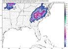
Late March cold is upper 50s and low 60s. Give up Nicole.Whether you like it or not cold will come if these looks continue .. we will suffer through more heat and above average temps until maybe the 2nd week of march .. but when that trough out west breaks down and the -NAO ridge builds in and retrogrades west enough.. fun things will happen underneath. Enjoy the warmth now cause it will be cold again. View attachment 133449View attachment 133450View attachment 133451


I’m beyond bitter!! I’m Tom Brady Sucks mad!!!!
That's a lot of winter weather advisories; good to see at least some parts of the country got to experience it this year. Yes, I'm a bit bitter...
This torch is awesome
That's a lot of winter weather advisories; good to see at least some parts of the country got to experience it this year. Yes, I'm a bit bitter...
Next winter is our year. Can’t have a great winter every year !
That's a lot of winter weather advisories; good to see at least some parts of the country got to experience it this year. Yes, I'm a bit bitter...
Next winter is our year. Can’t have a great winter every year !
Next winter is our year. Can’t have a great winter every year !
I know but I really feel good this time about next winter. It's going to be the complete opposite of this winter.People say that every year ?
I guess I'll resort to images of fantasy snow... Wow, beautuful, huh?I’m beyond bitter!! I’m Tom Brady Sucks mad!!!!

I know but I really feel good this time about next winter. It's going to be the complete opposite of this winter.

 ktla.com
Winter lives.
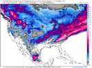
Southern California braces for cooler temps, heavy rain and lower elevation snow
Southern California is bracing for the coldest storm of the winter and likely the coldest storm in many years, which will bring rain and lower-elevation snow to the region. The weather will shift d…
Sent from my iPhone using Tapatalk
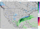
They need the water, so I guess that's good, though I never really want to see California prosper, generally.Mt. Baldy is 44 miles from downtown LA. They are expecting 2-5 feet of snow. Feet.
Sent from my iPhone using Tapatalk
You’re probably right about winter precipitation going forward, but a warm February doesn’t necessarily mean nothing in March. In both 2017 and 2018 February averaged well above normal with multiple days reaching 80 degrees at CLT and RDU, and we still managed an accumulating snowfall in March 2017 and several small events in March 2018. February 2018 was actually the warmest on record at KCLT, 8.8 degrees above normal. March 2018 ended up being 3.6 below normal with trace snowfall amounts on 5 different days.It’s been too warm for us to have any winter precipitation going forward.
Yes, sorry I just went sarcastic with my post. People always say things like “it’s been too warm to snow”.You’re probably right about winter precipitation going forward, but a warm February doesn’t necessarily mean nothing in March. In both 2017 and 2018 February averaged well above normal with multiple days reaching 80 degrees at CLT and RDU, and we still managed an accumulating snowfall in March 2017 and several small events in March 2018. February 2018 was actually the warmest on record at KCLT, 8.8 degrees above normal. March 2018 ended up being 3.6 below normal with trace snowfall amounts on 5 different days.
Might as well be, it was too warm in Jan and Feb too. Winter weather is about as intimidating as the Mulkies. What did they win, one match their entire careers?It’s going to be to warm to snow in March for most of us.
Sent from my iPhone using Tapatalk
") 30 years ago this month..
30 years ago this month.. products.climate.ncsu.edu
products.climate.ncsu.edu
products.climate.ncsu.edu
products.climate.ncsu.edu
products.climate.ncsu.edu
products.climate.ncsu.edu
products.climate.ncsu.edu
products.climate.ncsu.edu
products.climate.ncsu.edu
Great research right there.@Avalanche
(I seen what you did there).. So
Too be Fair, (listed it @ the bottom)
Moving My post from the March thread, As not to Rile-up the MODS..
Anyhoo..
Folks DO NOT give up HOPE..
I dug into the NCSU Database..
Looked through the Data Base, (going back too 1959).. Checking boxes only for SNOW & ICE & Freezing Precip.. (Just for N.C.)..
All OUR MARCH Winter Storms (just snow & freezing stuff)..
What I found..... MOST interesting,, IS,,
Any & ALL the storms that occurred in March,, Were in fact,,,
Board wide (snow Storms), in NC..
Mountains too the Coast..
Maybe this should be in the "Wamby Thread" though...
SO,, I moved My post here....
ALL links Include Synoptic set-ups & Maps.
March 2~3rd 1960
Snow and sleet averaged about a foot deep in the Mountains, ranging downward to a trace on the immediate coast.
Winter Storm Event – Products | North Carolina State Climate Office
March 9th~10th 1960
A snow and ice storm was similar to that of a week before.
Board wide Snow to the Coast, ILM even received 5"
https://products.climate.ncsu.edu/weather/winter/event/?e=5
March 11th ~ 12th 1960
(EDIT: what a YEAR to (be alive), &&& experience in 1960! during the month of March in N.C.!)
Considerable additional accumulation of snow in the Mountains and southern Piedmont following the snow earlier in the same week, was followed by the greatest March snow of record on the immediate coast.
in the northern Mountains where total snow accumulations reached 3' with drifts to 30 FEET , marooning residents in isolated areas. Again, a board wide NC storm.. additional snow which continued to fall in flurries for several days.
Even Wilmington received 7+" from this Storm..
Winter Storm Event – Products | North Carolina State Climate Office
March 1st~4th 1971
Heavy precipitation the first few days of the month with mostly snow in the Mountains and rain elsewhere, but with some areas getting a mixture of snow, sleet, and rain.
Winter Storm Event – Products | North Carolina State Climate Office
March 1st~2nd 1980
@Shaggy & @Downeastnc Can ya'll give US, Historical accounts?I resided in the Panama Canal Zone at the time.. So, I missed it.
Be cool to hear of your personal accounts.. If ya'll are *OLD* like Me, your what 18~20 something then? Fess-up now..
(See below)..
On the afternoon and evening of March 2, 1980 North Carolina experienced a major winter storm with heavy snow across the entire state and near blizzard conditions in the eastern part of the state. Snowfall totals were reported as 2 to 7 inches in the mountains, 6 to 8 inches in the piedmont, 12 to 18 inches in the coastal plain, and 7 to 12 inches in the southern coastal area ranging up to 25 inches at Elizabeth City.
one of the biggest snowstorms that eastern North Carolina has ever seen. Winds caused snow drifts up to 8 feet.
Winter Storm Event – Products | North Carolina State Climate Office
It was dubbed the ‘Snowstorm of the Century’ and it happened in early March of 1980.*
During the afternoon and evening of March 2, 1980, North Carolina experienced a major winter storm. Heavy snow and blustery conditions combined to reach almost blizzard conditions. The National Weather Service defines a blizzard as a storm that contains large amounts of snow or blowing snow, with winds in excess of 35 MPH and visibility down to less than a quarter of a mile for at least 3 hours.
https://www.weather.gov/mhx/Mar011980EventReview#:~:text=The precipitation in Eastern North Carolina started as,offshore to 999 mb by 00Z March 3.
Heavy Snow, Blizzard
https://products.climate.ncsu.edu/w...1&end_year=2022&event[]=snow&event[]=ice&pg=3
March 24~25th, 1983
An unusually late winter storm moved through the state producing heavy snow and gale-force winds. Also uncommon was the area of heaviest snow, which extended from the Southern and central Piedmont into the entire coastal area. Snowfall started around dawn near Charlotte and quickly moved northeast.
Snowfall amounts include: Greensboro Trace, Asheville 1", Raleigh-Durham 3", Charlotte 10", Fayetteville 9", Greenville 5", Clinton 8", Elizabeth City 7" and Wilmington 5".
Winter Storm Event – Products | North Carolina State Climate Office
EDIT: How could I forget? just for @Avalanche , 30 years ago, this Month.. What We couldn't see nor Forecast..
March 12th~14th
The Massive North Carolina Blizzard Of March 1993 Will Never Be Forgotten
Called ‘the storm of the century,’ those who lived through the record-breaking snowfall of 1993 still talk about it to this day. The strangest part about this snow is that it didn’t occur during your normal snowfall months; it created catastrophe in the middle of March. Just as students at UNC Asheville were preparing for spring break they woke up to over two feet of snow. Throughout the southeast, the storm brought devastation to more than just the Tar Heel State, and although it’s not the largest blizzard in North Carolina history, it still holds records to this day.
https://www.onlyinyourstate.com/north-carolina/1993-snow-storm-nc/
On This Day: The 1993 Storm of the Century
In March 1993, the Storm of the Century struck the U.S. East Coast, claiming more than 270 lives and causing billions of dollars in damage.www.ncei.noaa.gov
RDU posters like myself would be in shambles. I’d have to go back to my parents’ place in Greensboro lol.Could you imagine how bonkers this place would go if we had a repeat of March 93 ?
Some of our posters would be mad because it didn't already feel like summer.?Could you imagine how bonkers this place would go if we had a repeat of March 93 ?
Some of our posters would be mad because it didn't already feel like summer.


It's a funny coincidence but I'm also looking into ML with my senior project for CS. While I'm no met major, I want to see how possible it is to nowcast things like strong wind, hail, and tornadoes in advance (hopefully up to an hour) at a high resolution as well pulling from live radar imagery. If successful I'd hope with sufficient training and time it be capable of giving a more precise idea where those hazards would occur. While it is quite ambitious and I am working alone and have yet to reach the ML aspect of it, it is a goal of both some research into ML's capabilities and possibly contributing to forecast improvement on the more technical methods.I'm working on a new AI model using deep ML methods to forecast tornadoes on a high resolution scale. Originally I was going for a lower resolution SPC-like/Nadocast-like system, but figured it'd be more fruitful and potentially save more lives if it were higher resolution and focused on the 12-36hrs before the tornado. It is trained, tested, and fed forecasts by the MMFS-superres model. Since it is all in-house, the AI has access to many advanced variables not typically available for models, such as microphysics properties, leveled wind components in the PBL, SRH/UDHEL within the PBL, and more. The first test forecast I did was on Jan 12, 2023 and it gave a hell of a forecast, especially considering it's young age. I'm hoping to have it in a really good spot by late march into April. Overall very optimistic about this, especially given how well the first full test forecast did.
View attachment 133517
I’m going skiing tomorrow at Sugar as I currently bask in my hot car. ?playing golf today, really excited
Great goals! While I don’t think that ML-only is the future of weather/severe wx/tornado forecasting, I think it could play a big part in interpretation of physical cored models.It's a funny coincidence but I'm also looking into ML with my senior project for CS. While I'm no met major, I want to see how possible it is to nowcast things like strong wind, hail, and tornadoes in advance (hopefully up to an hour) at a high resolution as well pulling from live radar imagery. If successful I'd hope with sufficient training and time it be capable of giving a more precise idea where those hazards would occur. While it is quite ambitious and I am working alone and have yet to reach the ML aspect of it, it is a goal of both some research into ML's capabilities and possibly contributing to forecast improvement on the more technical methods.
Sweet! Keep us posted and reminded of this as it matures.I'm working on a new AI model using deep ML methods to forecast tornadoes on a high resolution scale. Originally I was going for a lower resolution SPC-like/Nadocast-like system, but figured it'd be more fruitful and potentially save more lives if it were higher resolution and focused on the 12-36hrs before the tornado. It is trained, tested, and fed forecasts by the MMFS-superres model. Since it is all in-house, the AI has access to many advanced variables not typically available for models, such as microphysics properties, leveled wind components in the PBL, SRH/UDHEL within the PBL, and more. The first test forecast I did was on Jan 12, 2023 and it gave a hell of a forecast, especially considering it's young age. I'm hoping to have it in a really good spot by late march into April. Overall very optimistic about this, especially given how well the first full test forecast did.
View attachment 133517