SimeonNC
Member
Wintery mix in New England? Okay then
Sent from my Z983 using Tapatalk
Wintery mix in New England? Okay then
2017-18 was solid for virtually everyone except Columbia lmao.

Here is the "Old" Farmer's Almanac Winter Map ...
Congrats Western NC ... probably accurate for the rest of us. I suppose we can use the rain!
View attachment 22961
Take this with a grain of saltHere is the "Old" Farmer's Almanac Winter Map ...
Congrats Western NC ... probably accurate for the rest of us. I suppose we can use the rain!
View attachment 22961
I just want rain anyway! I’ll take the soakers and mild and be happy! Who needs snow anyway? It’s overratedHere is the "Old" Farmer's Almanac Winter Map ...
Congrats Western NC ... probably accurate for the rest of us. I suppose we can use the rain!
View attachment 22961

.png)
.gif)
.gif)
.gif)
.gif)
.gif)
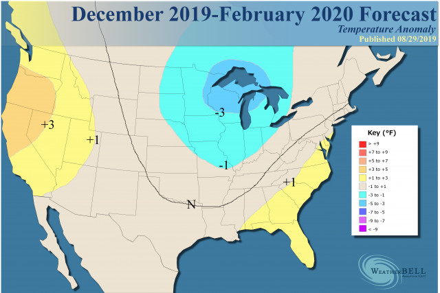
I don't think I'm seeing this right. JB just released his forecast for the winter and has a warm SE. Guys, I think this winter might be a doozyView attachment 23145
- Plenty of potential for a severe winter.
- East will have to overcome early warmth.
- SST analogs are amazingly close to a blend of 2013-14 and 2014-15.
- Warm northeastern Pacific and cooler Nino1+2 usually a great cold signal.
- Snowfall should be generous.
.
Finally a winter where he's showing above normal to normal temps here! About time! Maybe now we will see a big storm.I don't think I'm seeing this right. JB just released his forecast for the winter and has a warm SE. Guys, I think this winter might be a doozyView attachment 23145
- Plenty of potential for a severe winter.
- East will have to overcome early warmth.
- SST analogs are amazingly close to a blend of 2013-14 and 2014-15.
- Warm northeastern Pacific and cooler Nino1+2 usually a great cold signal.
- Snowfall should be generous.
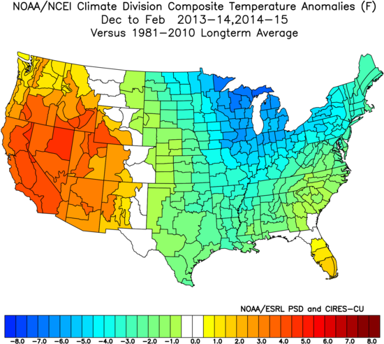
The sensible analog is skewed to make it less cold, for the actual analog is quite a bit colder than that.
Actual analog:
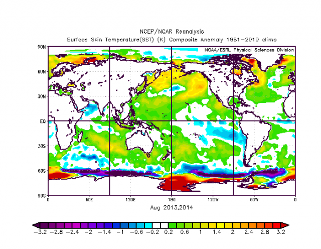
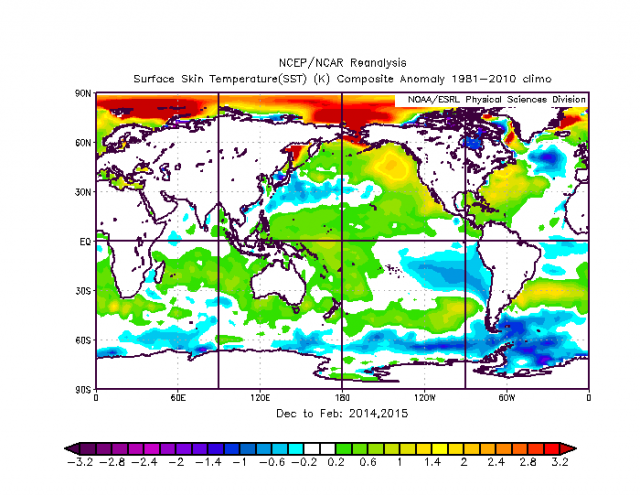
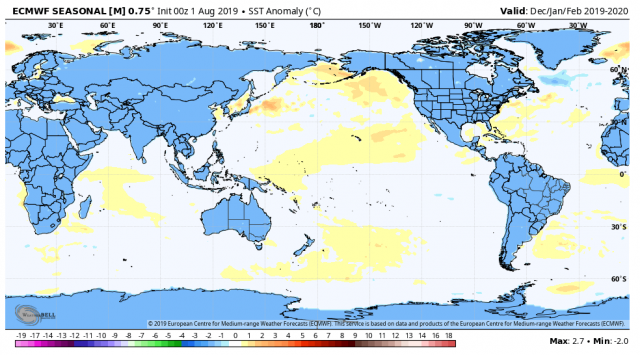
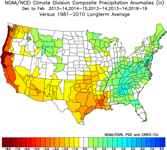
At this time in the Northern Hemisphere, the SSTs are amazingly close to a blend of 2013-14 and 2014-15. The blend:
Current:
It should also carry into the winter period.
Analog:
Euro forecast:
Keep in mind the increments here are much larger (1°C) than what is used on the analog (0.2°C). The CFSv2 also has tighter increments and is warm everywhere:
The warm ring in the Pacific and Nino1+2 being cooler than near the Dateline are there. In spite of this, the CFSv2 has a blow torch winter:
In the analog years, it had the same kind of idea:
The CFSv2's 2014-15's forecast was very bad:
So given those were the coldest winters together in this decade for the nation as a whole, I am taking it with a grain of salt.
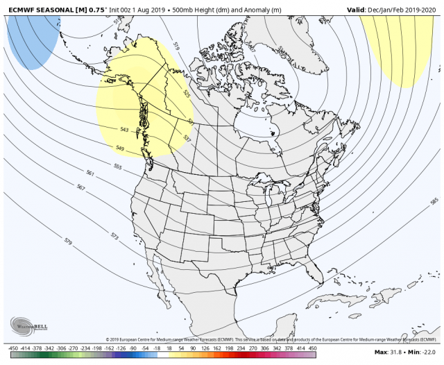
The Euro seasonal for December-February is like this in the upper levels:
That kind of ridge over northwestern Canada with the trough near the Dateline is going to force a lot of cold into the U.S.
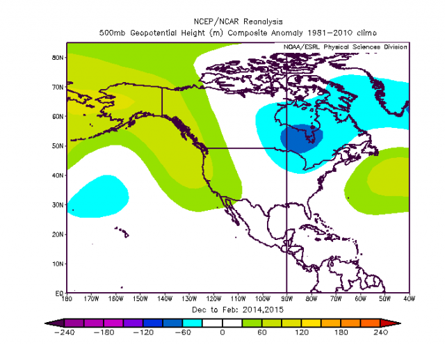
The 500 mb pattern in those winters:
You can see the ridge over northwestern Canada. Keep in mind this is what actually happened. The modeling, given the warm state of the Northern Hemisphere, can only hint at cold, but with that kind of ridge it opens up the door for severe cold. The idea is that the warmth of the SSTs off the East Coast will temper the cold in the early winter (there may be a false start in October), but until the solstice I think the warmth will win out in the East. At the same time cold will come into the Plains. January-March the cold should overwhelm the pattern from the Plains eastward.
Naturally the only model to see cold is the model that hits the cold when it comes, the Pioneer. Last year it busted badly in the Southeast, and I spent half the winter explaining what went on. However, what I did see was a lot of cold in the pattern. No surprise it looks quite cold given the analogs.
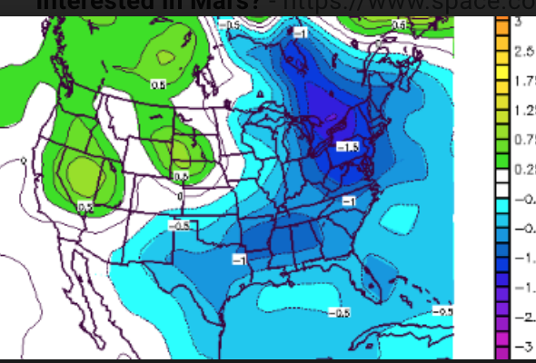
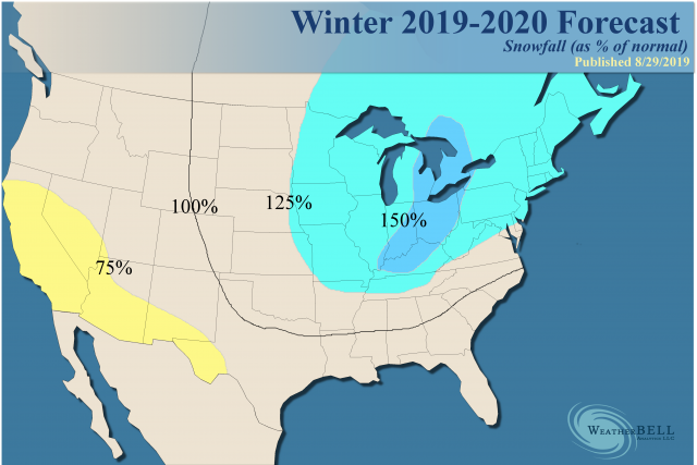
For snowfall, with ample reason to suspect a fight over the eastern part of the U.S. and the recent tendencies toward plentiful amounts of moisture, the cold that comes should produce plenty of snow. Last year's forecast got off to a great start with the Southeast getting early snow, and as the winter went on much of the area forecasted to have above normal snowfall did have it. However, there was a corridor over the Northeast in crucial areas that was only 75% of average. This year, with the cold the way it is expected to be, the analog precipitation is modeled to be like this:
This should produce a big snow year, centered over the Great Lakes and interior East. There will be plenty of opportunity to the East Coast and back into the Plains.
This is a percent of average, first flake to last. For example, in Atlantic City the average is about 15 inches of snow per year, so the forecast for 125% of that would be a bit over 18 inches. There is an area of 150% from the Ohio Valley into the Great Lakes. Pittsburgh's average of 40 inches, so it says they should get about 60. You can see a large area of above normal, and it's tricky because if this works out to its full potential, there could be more over the East Coast. Also, the southern Rockies is a place where more may have to be forecasted, but for now I am relying on a drier idea to win out there.
The Verdict
The conditions in the oceans around the U.S. are ripe for major arctic outbreaks, but the early season, as has been the habit of late, is likely to start warm in the East. The worst-case scenario is a brutally cold old-fashioned winter. Precipitation should be plentiful again in the East given, the natural fight between the cold air to the west and the warm oceans to the east.
The West looks warm, though the Euro would argue that the Pioneer is onto something, sticking more cold into the southern Rockies. Buckle up, there is going to be plenty of cold around with January-March being colder against the normals in the East than December-February. If you start late with the winter, you are liable to end late.
Your area is actually in the normal temps zone. Just be glad you dont live in the south metro !Finally a winter where he's showing above normal to normal temps here! About time! Maybe now we will see a big storm.
Good, now the southeast is in for a cold and snowy winter. Thanks JB, we always go with the opposite of your forecastI don't think I'm seeing this right. JB just released his forecast for the winter and has a warm SE. Guys, I think this winter might be a doozyView attachment 23145
- Plenty of potential for a severe winter.
- East will have to overcome early warmth.
- SST analogs are amazingly close to a blend of 2013-14 and 2014-15.
- Warm northeastern Pacific and cooler Nino1+2 usually a great cold signal.
- Snowfall should be generous.
The sensible analog is skewed to make it less cold, for the actual analog is quite a bit colder than that.
Actual analog:
At this time in the Northern Hemisphere, the SSTs are amazingly close to a blend of 2013-14 and 2014-15. The blend:
Current:
It should also carry into the winter period.
Analog:
Euro forecast:
Keep in mind the increments here are much larger (1°C) than what is used on the analog (0.2°C). The CFSv2 also has tighter increments and is warm everywhere:
The warm ring in the Pacific and Nino1+2 being cooler than near the Dateline are there. In spite of this, the CFSv2 has a blow torch winter:
In the analog years, it had the same kind of idea:
The CFSv2's 2014-15's forecast was very bad:
So given those were the coldest winters together in this decade for the nation as a whole, I am taking it with a grain of salt.
The Euro seasonal for December-February is like this in the upper levels:
That kind of ridge over northwestern Canada with the trough near the Dateline is going to force a lot of cold into the U.S.
The 500 mb pattern in those winters:
You can see the ridge over northwestern Canada. Keep in mind this is what actually happened. The modeling, given the warm state of the Northern Hemisphere, can only hint at cold, but with that kind of ridge it opens up the door for severe cold. The idea is that the warmth of the SSTs off the East Coast will temper the cold in the early winter (there may be a false start in October), but until the solstice I think the warmth will win out in the East. At the same time cold will come into the Plains. January-March the cold should overwhelm the pattern from the Plains eastward.
Naturally the only model to see cold is the model that hits the cold when it comes, the Pioneer. Last year it busted badly in the Southeast, and I spent half the winter explaining what went on. However, what I did see was a lot of cold in the pattern. No surprise it looks quite cold given the analogs.
For snowfall, with ample reason to suspect a fight over the eastern part of the U.S. and the recent tendencies toward plentiful amounts of moisture, the cold that comes should produce plenty of snow. Last year's forecast got off to a great start with the Southeast getting early snow, and as the winter went on much of the area forecasted to have above normal snowfall did have it. However, there was a corridor over the Northeast in crucial areas that was only 75% of average. This year, with the cold the way it is expected to be, the analog precipitation is modeled to be like this:
This should produce a big snow year, centered over the Great Lakes and interior East. There will be plenty of opportunity to the East Coast and back into the Plains.
This is a percent of average, first flake to last. For example, in Atlantic City the average is about 15 inches of snow per year, so the forecast for 125% of that would be a bit over 18 inches. There is an area of 150% from the Ohio Valley into the Great Lakes. Pittsburgh's average of 40 inches, so it says they should get about 60. You can see a large area of above normal, and it's tricky because if this works out to its full potential, there could be more over the East Coast. Also, the southern Rockies is a place where more may have to be forecasted, but for now I am relying on a drier idea to win out there.
The Verdict
The conditions in the oceans around the U.S. are ripe for major arctic outbreaks, but the early season, as has been the habit of late, is likely to start warm in the East. The worst-case scenario is a brutally cold old-fashioned winter. Precipitation should be plentiful again in the East given, the natural fight between the cold air to the west and the warm oceans to the east.
The West looks warm, though the Euro would argue that the Pioneer is onto something, sticking more cold into the southern Rockies. Buckle up, there is going to be plenty of cold around with January-March being colder against the normals in the East than December-February. If you start late with the winter, you are liable to end late.
We already know it'll be warm! Don't worry, our 2 week winter in January will produce our 2 inches of sleet.Gives me 100% of normal snowfall! 3” or bust!
A lot better than the fake news 200% I was forecasted the last 2 winters!
")
Didn't know Mass. had those same named towns ...I'm leaning heavily on the PIONEER MODEL! FTW! Rain/Snow line should be just north of Greenville/Spartanburg area this winter.
I’m only going with GFSv3I'm leaning heavily on the PIONEER MODEL! FTW! Rain/Snow line should be just north of Greenville/Spartanburg area this winter.
I'm going with whatever comes out of the sky ...I’m only going with GFSv3
Take a look at my signature....I'm leaning heavily on the PIONEER MODEL! FTW! Rain/Snow line should be just north of Greenville/Spartanburg area this winter.
Take this with a grain of salt
I take any seasonal forecast with many grains of salt lol. Of course, I think they claim 85 percent accuracy. Amazing the spread of forecasts, but for me, better to go warm and bust than cold and bust.
As always, we will look forward to winter and always have that hope that brings us here.
There really isn’t any reason people in AL and east GA shouldn’t be optimistic concerning winter considering the past ten years.
There really isn’t any reason people in AL and east GA shouldn’t be optimistic concerning winter considering the past ten years.
Yknow i feel like i'm always disappointed with the amount of snow i get here (looking at you December 2018 storm)Right, I’ve seen snow here 6 out of past 10 winters.
Compared to the 2000s that’s just amazing to think about.
My dream winter is three big ones (6-8")... Xmas, January, FebruaryLast winter gave me a refresher course on not buying into winter forecasts no matter how good or bad they are. It was supposed to be a blockbuster winter last season. Early on it looked like it would be as I got my first dusting on November 15th and some freezing rain in early December. After that though the best snow I got wasn’t even one inch followed by a few more flurry events.The truth is we won’t really know what the winter will bring each season until it is among us. I do hope and pray that February won’t torch for a 3rd season in a row though. My perfect winter season would be to get some late December snows followed by some late February thumpers!
Last winter gave me a refresher course on not buying into winter forecasts no matter how good or bad they are. It was supposed to be a blockbuster winter last season. Early on it looked like it would be as I got my first dusting on November 15th and some freezing rain in early December. After that though the best snow I got wasn’t even one inch followed by a few more flurry events.The truth is we won’t really know what the winter will bring each season until it is among us. I do hope and pray that February won’t torch for a 3rd season in a row though. My perfect winter season would be to get some late December snows followed by some late February thumpers!
I’m at 900 feet in elevation.What is your elevation?
To me it is strange how consistently warm September and February have been, even May to some extent. All transition months.
We all want a cold snowy winter, or at least most do. Anthony Masiello said early on that it would be most like 94-95 last winter, which it really was for the most part. He is really good with patterns imo. Try to pay attention to him on twitter. Apparently the hadley cell was out of sync with the overall pattern. He mentioned that quite alot.
Yea the Southeast has done really well during the 2010's. If you got shafted i'm sorry, but we are bound to do worse in the 2020's. I didn't see a single flake last year, and I would be surprised to see one this year tbh.
Lol guess i'm one of the few that want it cold. Gimmie highs in the 30s/40s/low 50s for a month pls1. Golf,
Most active posters obviously want a snowy winter (which is often accomplished from from just one significant storm) but it isn't clear to me that most of the more vocal members want it cold, too. Based on past posts, a good number would prefer snowy but with it being not so cold or even mild, which of course is quite doable in the SE US. I recall many posts with folks whining when it is cold but dry.
2. JB's forecast is not for a mild E US winter but rather for a near normal one and he could easily still end up much too warm as it is based on most of the 2010s. However, relative to his usual, yes he's predicting intense heat lol.
Lol guess i'm one of the few that want it cold. Gimmie highs in the 30s/40s/low 50s for a month pls
Give me cold, Larry, for 8 - 10 weeks ... a few hard freezes, lots of 20's in between them, and ergo no Cuban frogs ... if in the process a flake falls or a pellet pings, Hogtown has won!I didn't mean to imply that I think only a few want it cold. I do think many like myself (although I don't mind the normal mild interludes that will just about always show up in the SE and I love winter much more than summer regardless of how mild it is) want it cold, regardless of snow. But Golf said "We all want a cold snowy winter, or at least most do.", which I think is overstating it regard the cold part because I think at least a very sizable and vocal minority don't like the cold when it isn't also with snow (which is most of the time in the SE).
...