The blocking will disappear in December and return in April, just like the last 8-9 winters or so!If we get plenty of blocking, there will be more than one decent snow here. That’s going to be the key this winter. And right now, I’m not all that unhappy with what I’m seeing in that area. But we have a long way to go.
-
Hello, please take a minute to check out our awesome content, contributed by the wonderful members of our community. We hope you'll add your own thoughts and opinions by making a free account!
You are using an out of date browser. It may not display this or other websites correctly.
You should upgrade or use an alternative browser.
You should upgrade or use an alternative browser.
Wintry Winter 2018-19 Discussion
- Thread starter Snowfan
- Start date
B
Brick Tamland
Guest
Will you so the same?The blocking will disappear in December and return in April, just like the last 8-9 winters or so!
cd2play
Member
You don't think Mother Nature is deliberately mocking us, do you?The blocking will disappear in December and return in April, just like the last 8-9 winters or so!
pcbjr
Member
She's a bee, for sure ...You don't think Mother Nature is deliberately mocking us, do you?
That’s not very nice. Insult season doesn’t begin until 12/1!Will you so the same?
Probably.The blocking will disappear in December and return in April, just like the last 8-9 winters or so!
cd2play
Member
SimeonNC
Member
I see no reason to be negative about this so far out, the signs so far are pretty in our favor. On another note, does anyone know the relationship QBO has with El Nino? We might be transitioning to a positive QBO during the winter months and I wanna know how it might affect conditions.
Jon
Member
I see no reason to be negative about this so far out, the signs so far are pretty in our favor. On another note, does anyone know the relationship QBO has with El Nino? We might be transitioning to a positive QBO during the winter months and I wanna know how it might affect conditions.
West or +QBO is associated with a +PNA and east coast trough, with cold temps east. El Niños with a +QBO would feature more snow events in the SE.
Sent from my iPhone using Tapatalk
Jon
Member
Euro seasonal fwiw. Dec-Feb rockin’


Sent from my iPhone using Tapatalk


Sent from my iPhone using Tapatalk
accu35
Member
Great signs. Thanks Jon.Euro seasonal fwiw. Dec-Feb rockin’


Sent from my iPhone using Tapatalk
SimeonNC
Member
Okay so an inverse of the -QBO/Cool ENSO combination, well unless the QBO starts going positive really quickly, we might not see any effects of a positive QBO until either the tail end or after winter is over.West or +QBO is associated with a +PNA and east coast trough, with cold temps east. El Niños with a +QBO would feature more snow events in the SE.
Sent from my iPhone using Tapatalk
SimeonNC
Member
By the way, I recommend all of you to check out a YouTube channel called GavsWeatherVids, he mainly focuses on the UK and Europe but every Sunday he does these updates on conditions such as SST, Solar, etc. and starting in September he will be doing weekly updates on the factors that affect our winter. He's one of the best if not the best of these YouTube meteorologists.
Jon
Member
Okay so an inverse of the -QBO/Cool ENSO combination, well unless the QBO starts going positive really quickly, we might not see any effects of a positive QBO until either the tail end or after winter is over.
I actually don’t see the QBO going positive. Currently very negative and east based...usually takes over a year to reverse so we likely won’t get a +QBO until next winter.
Sent from my iPhone using Tapatalk
SimeonNC
Member
Oh okay, I was going off an analog I saw in a video where a similarly negative QBO that was around this time period ended up going positive early in the next year. I think it was 2005-6.I actually don’t see the QBO going positive. Currently very negative and east based...usually takes over a year to reverse so we likely won’t get a +QBO until next winter.
Sent from my iPhone using Tapatalk
Jon
Member
Oh okay, I was going off an analog I saw in a video where a similarly negative QBO that was around this time period ended up going positive early in the next year. I think it was 2005-6.
Actually my bad we’ve been in a -QBO for about a year so we’re due to head positive soon. So that’s right. 05-06 was already positive by this time though, and we’re still -20s.
A good analog of the reversal might be 09-10 (strong El Niño) or 91-92 (strong El Niño), or better yet 86-87 (moderate El Niño which is likely). Might be better analogs but I looked quick for recent history with similar May QBO and base states.
Sent from my iPhone using Tapatalk
Man, if you, we , had 2 winters in a row where ATL gets a foot and CHS gets 6-8” and you get the cloud flizzard, could be Harry Carrey!Probably.
Euro seasonal fwiw. Dec-Feb rockin’


Sent from my iPhone using Tapatalk
Man it would be nice if that look would come fruition this winter!!
Sent from my iPhone using Tapatalk
Jon
Member

So are we going to see people hype the new JAMSTEC? My guess is no...
Remember this is the one from last month..

Lesson here is lead times matter. 4-5 months out is no good. The CFSv2 usually struggles a month out and doesn’t get a hint until the last week of a monthly prediction. Our models are simply not good yet for seasonal forecasts.
Sent from my iPhone using Tapatalk
whatalife
Moderator

So are we going to see people hype the new JAMSTEC? My guess is no...
Remember this is the one from last month..

Lesson here is lead times matter. 4-5 months out is no good. The CFSv2 usually struggles a month out and doesn’t get a hint until the last week of a monthly prediction. Our models are simply not good yet for seasonal forecasts.
Sent from my iPhone using Tapatalk
Why trust models this far out when they can’t even get Day 7 right...

Sent from my iPhone using Tapatalk
Jon
Member
Why trust models this far out when they can’t even get Day 7 right...
Sent from my iPhone using Tapatalk
True! People love seasonal because they feel like it’s a crystal ball. They’re fun to see when they predict an awesome winter (like the euro seasonal) but it’s basically for fun this far out.
Sent from my iPhone using Tapatalk

So are we going to see people hype the new JAMSTEC? My guess is no...
Remember this is the one from last month..

Lesson here is lead times matter. 4-5 months out is no good. The CFSv2 usually struggles a month out and doesn’t get a hint until the last week of a monthly prediction. Our models are simply not good yet for seasonal forecasts.
Thanks for posting, Jon. Do you have a link to this? I want to see if there’s also an updated ENSO prediction. I looked around at the JAMSTEC site and saw no predictions from August for some reason. Maybe it went El Niño before and no longer is?? Admittedly, this isn’t good news from my perspective as I had already touted JAMSTEC to Phil as being decent for a seasonal model and really feel that way. I’d be a hypocrite if I now said to ignore this, especially with it being a month closer to DJF. Has the updated Euro come out? I know that Eurosip doesn’t go that far out for air temperatures.
Last edited:
Jon
Member
Thanks for posting, Jon. Do you have a link to this? I want to see if there’s also an updated ENSO prediction. I looked around at the JAMSTEC site and saw no predictions from August for some reason. Maybe it went El Niño before and no longer is?? Admittedly, this isn’t good news from my perspective as I had already touted JAMSTEC to Phil as being decent for a seasonal model and really feel that way. I’d be a hypocrite if I now said to ignore this, especially with it being a month closer to DJF. Has the updated Euro come out? I know that Eurosip doesn’t go that far out for air temperatures.
Larry - no worries, the JAMSTEC isn’t as bad as others, it’s just not good this far out. I got to this months maps a bit early as usually they post around the 20th, basically they should update their ENSO post early next week. I just check their site at the bottom to see if the model has updated.
The updated euro seasonal comes out on the 11th of each month and that is freely available on weather.us (for now)
I would wait a little for this nino to get going before trusting them atm (I know SSTs are built into seasonals and show nino, but it’s like trusting a hurricane model track or intensity before the tropical storm forms...to me at least)
The JAMSTEC still has a nino but definitely is a tad weaker
July forecast

August

And modoki actually decreased
July

August

Sent from my iPhone using Tapatalk
Last edited:
Kylo
Member
For those that want to play with the Jamstec seasonal model
http://www.jamstec.go.jp/frsgc/research/d1/iod/sintex_f1_forecast.html.en
http://www.jamstec.go.jp/frsgc/research/d1/iod/sintex_f1_forecast.html.en
B
Brick Tamland
Guest
I wonder what this pattern will bring to the Triangle as far as winter storms.
A) Nothing at all
B) A bunch of little storms
C) One or two big storms
D) A mix of some smaller storms and one or two big dogs
A) Nothing at all
B) A bunch of little storms
C) One or two big storms
D) A mix of some smaller storms and one or two big dogs
snowlover91
Member
True! People love seasonal because they feel like it’s a crystal ball. They’re fun to see when they predict an awesome winter (like the euro seasonal) but it’s basically for fun this far out.
Yep at this point the seasonal models aren't useful for much other than entertainment purposes. The CFS usually does a decent job if you look at it for the last day of the month to see what it shows for the next month but that's about it. Outside of that the seasonal models have a pretty strong warm bias so long term lead times several months in advance even can be way off.
Here's a good example from the NMME model. Here is the April run for July of this year compared with the actual temperature anomalies.

Notice the CANSIPS model also completely missed the boat and was way too warm for many areas. The Arctic cooling, cold Greenland and Siberia were key areas all missed by the climate models even just a few months out.

Now compare that with what actually happened.

Last edited:
accu35
Member
:quality(80):max_bytes(100000):sharpen(0.2%2C1%2Cfalse):strip_exif():strip_icc()/https://cdn-snowboarding.transworld.net/blogs.dir/442/files/2018/08/old-farmers-almanac-winter-2019-twsnow-forecast-1000x678.jpg)
NoSnowATL
Member
Mild yet snowy? Kinda like wet but dry.am I missing something here? I though El NINO brings cold to the SE?:quality(80):max_bytes(100000):sharpen(0.2%2C1%2Cfalse):strip_exif():strip_icc()/https://cdn-snowboarding.transworld.net/blogs.dir/442/files/2018/08/old-farmers-almanac-winter-2019-twsnow-forecast-1000x678.jpg)
am I missing something here? I though El NINO brings cold to the SE?:quality(80):max_bytes(100000):sharpen(0.2%2C1%2Cfalse):strip_exif():strip_icc()/https://cdn-snowboarding.transworld.net/blogs.dir/442/files/2018/08/old-farmers-almanac-winter-2019-twsnow-forecast-1000x678.jpg)
What is this from? This looks dumb to me.
ForsythSnow
Moderator
Sounds like the worst possible combination but they aren't always right and likely are gambling since El Ninos typically are wet all along the gulf. Looks more like a neutral cool ENSO or even Nina type of forecast it's based on.am I missing something here? I though El NINO brings cold to the SE?:quality(80):max_bytes(100000):sharpen(0.2%2C1%2Cfalse):strip_exif():strip_icc()/https://cdn-snowboarding.transworld.net/blogs.dir/442/files/2018/08/old-farmers-almanac-winter-2019-twsnow-forecast-1000x678.jpg)
SimeonNC
Member
Honestly that farmer's almanac forecast only gives me hope.
cd2play
Member
Warm and wet means severe weather.am I missing something here? I though El NINO brings cold to the SE?:quality(80):max_bytes(100000):sharpen(0.2%2C1%2Cfalse):strip_exif():strip_icc()/https://cdn-snowboarding.transworld.net/blogs.dir/442/files/2018/08/old-farmers-almanac-winter-2019-twsnow-forecast-1000x678.jpg)
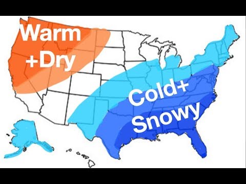
Yeah , that looks like a typical El Niño map! Not!!Warm and wet means severe weather.
accu35
Member

Where is this from? This looks smart to me.Then you got one forecaster really nailing it with 2018,2019 winter forecast
accu35
Member
Youtube lol.Where is this from? This looks smart to me.
pcbjr
Member
Whomever it was that drew the map obviously never spent a winter in Gainesville, FL ... LOL ... "oblviously" ...Where is this from? This looks smart to me.
Last edited:
E.) no snow for south wakeI wonder what this pattern will bring to the Triangle as far as winter storms.
A) Nothing at all
B) A bunch of little storms
C) One or two big storms
D) A mix of some smaller storms and one or two big dogs
Then you got one forecaster really nailing it with 2018,2019 winter forecast
Obviously, a lot of thought was put into this forecast. Very well reasoned. Thank you, accu, for posting.
ForsythSnow
Moderator
Lol yep. Miami will have record snowfall as will the entire state of FloridaObviously, a lot of thought was put into this forecast. Very well reasoned. Thank you, accu, for posting.
