 Booooooom! Drops mic....
-
Hello, please take a minute to check out our awesome content, contributed by the wonderful members of our community. We hope you'll add your own thoughts and opinions by making a free account!
You are using an out of date browser. It may not display this or other websites correctly.
You should upgrade or use an alternative browser.
You should upgrade or use an alternative browser.
Wintry Winter 2018-19 Discussion
- Thread starter Snowfan
- Start date
ForsythSnow
Moderator
Kiss of death. Now I expect to see not a single accumulating flake.View attachment 5579 Booooooom! Drops mic....

 Follow up: Courtesy of NGa weather!!! Boooooooooooooooooooom! Pics up mic, drops again!
Pants busted!
I havnt seen something that beautiful, since I saw a sign for Chic Fil A, all you can eat nugget night!!!:weenie::weenie::weenie:Pants busted!
ForsythSnow
Moderator
Given their track record I'm calling that map the final nail in the coffin. Looks like what they should have issued last year for snowfall and seeing N GA in the bullseye of cold kills it. Probably going to be warmer than average and few flakes.View attachment 5580 Follow up: Courtesy of NGa weather!!! Boooooooooooooooooooom! Pics up mic, drops again!
I would like to see it happen that way though and maybe since JB's backyard isn't in the bullseye there is an actual chance.
ForsythSnow
Moderator
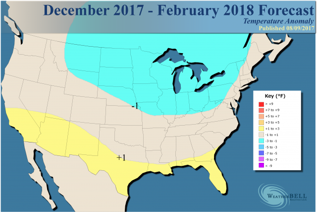
WeatherBell's prediction last year vs reality
.png)
Here's the recorded DJF anomalies. I'll say they were a little too cool biased but the zones were close.
As far as snowfall, we all know how that ended up from the multiple storms.
All we really can do is wait and see how the forecast holds into December, which is still 4 months away.
Here's the recorded DJF anomalies. I'll say they were a little too cool biased but the zones were close.
As far as snowfall, we all know how that ended up from the multiple storms.
All we really can do is wait and see how the forecast holds into December, which is still 4 months away.
whatalife
Moderator
This man is riding the seasonal models like a mad man.Given their track record I'm calling that map the final nail in the coffin. Looks like what they should have issued last year for snowfall and seeing N GA in the bullseye of cold kills it. Probably going to be warmer than average and few flakes.
I would like to see it happen that way though and maybe since JB's backyard isn't in the bullseye there is an actual chance.
ForsythSnow
Moderator
Lol, who really knows at this point. Its weatherbell and the seasonals so it's something other than nothing. I'm hoping for the best but expecting the worst as always when it comes to winter but it's just too early right now to say anything is definite.This man is riding the seasonal models like a mad man.
Dude, forget about snow....where was that?!?!I havnt seen something that beautiful, since I saw a sign for Chic Fil A, all you can eat nugget night!!!:weenie::weenie::weenie:
Cad Wedge NC
Member
Despite the fact that I would love to see something like that happen, I highly doubt it will play out that way. All depends on a number of factors that we just can't predict this far out. Heck, we don't even know for sure if we will have a Nino this winter. That's the first step.View attachment 5580 Follow up: Courtesy of NGa weather!!! Boooooooooooooooooooom! Pics up mic, drops again!
B
Brick Tamland
Guest
View attachment 5580 Follow up: Courtesy of NGa weather!!! Boooooooooooooooooooom! Pics up mic, drops again!

They used to have that at 2 or 3 locations in Greenville! It was 11.99$ on Wednesday’s, they would just keep bringing around 12 packs and fries until you said “ no mas” , it was a thing of beauty! And they had sauces stacked about a foot tall on the counter for the taking!! I went twice and probably easily ate 36-48, stayed off the waffle fries!Dude, forget about snow....where was that?!?!
TWC said this morning 70% chance of El Niño forming by December!
Also, if any of y’all like Long John Silvers, they have all you can eat fish and chicken around here on Sunday’s, for 7.99$ !!!!
Also, if any of y’all like Long John Silvers, they have all you can eat fish and chicken around here on Sunday’s, for 7.99$ !!!!
View attachment 5580 Follow up: Courtesy of NGa weather!!! Boooooooooooooooooooom! Pics up mic, drops again!
This Wxbell DJF forecast is essentially ~2009-10 all over again, which at the time was the coldest winter by a good margin since 1977-8.
The -5 shown on the map for KATL would make it a top 10 cold winter in terms of anomalies vs normal of the time. I wonder what they're using for normals....1981-2010? That's actually colder than the non-Pioneer seasonal maps are showing as they are closer to -2 to -4 range.
After getting near 1,000% of my normal wintry precip in 2017-8 (SN/IP/ZR)..well from the one early January generational historic storm, this 167% would be a letdown lol.
KATL is ~4" SN/IP at 200%, which is about what they're calling for.
Last edited:
pcbjr
Member
... and so long as you are calculating, Gainesville (FL, that is ...)? ... Truly LOL ...This Wxbell DJF forecast is essentially ~2009-10 all over again, which at the time was the coldest winter by a good margin since 1977-8.
The -5 shown on the map for KATL would make it a top 10 cold winter in terms of anomalies vs normal of the time. I wonder what they're using for normals....1981-2010? That's actually colder than the non-Pioneer seasonal maps are showing as they are closer to -2 to -4 range.
After getting near 1,000% of my normal wintry precip in 2017-8 (SN/IP/ZR)..well from the one early January generational historic storm, this 167% would be a letdown lol.
KATL is ~4" SN/IP at 200%, which is about what they're calling for.
Severe stormfail warning in affek!
pcbjr
Member
RC,Severe stormfail warning in affek!
That's plagiarising from a newspaper that was thrown in the driveway sometime last winter ...
Oh man, that’s amazing. I wish they’d do that here!They used to have that at 2 or 3 locations in Greenville! It was 11.99$ on Wednesday’s, they would just keep bringing around 12 packs and fries until you said “ no mas” , it was a thing of beauty! And they had sauces stacked about a foot tall on the counter for the taking!! I went twice and probably easily ate 36-48, stayed off the waffle fries!
This Wxbell DJF forecast is essentially ~2009-10 all over again, which at the time was the coldest winter by a good margin since 1977-8.
The -5 shown on the map for KATL would make it a top 10 cold winter in terms of anomalies vs normal of the time. I wonder what they're using for normals....1981-2010? That's actually colder than the non-Pioneer seasonal maps are showing as they are closer to -2 to -4 range.
After getting near 1,000% of my normal wintry precip in 2017-8 (SN/IP/ZR)..well from the one early January generational historic storm, this 167% would be a letdown lol.
KATL is ~4" SN/IP at 200%, which is about what they're calling for.
I really hate basing winters on a three month average. Personally 2013-2014 and 2010-2011 were both colder than 2009-2010. That is my issue with winter predictions such as WxBell. A winter of above average temps can vastly outperform a winter of below average temps.
SimeonNC
Member
Exactly, wall-to-wall cold is't needed for a snowy winter overall. In recent years, prolonged cold for me has been more associated with dry weather than anything else. But maybe the potential for a more active STJ will change things up.I really hate basing winters on a three month average. Personally 2013-2014 and 2010-2011 were both colder than 2009-2010. That is my issue with winter predictions such as WxBell. A winter of above average temps can vastly outperform a winter of below average temps.
I really hate basing winters on a three month average. Personally 2013-2014 and 2010-2011 were both colder than 2009-2010. That is my issue with winter predictions such as WxBell. A winter of above average temps can vastly outperform a winter of below average temps.
Indeed, a warm winter can outperform here in the SE as it takes only one storm in many cases. And a wall to wall cold one can be void of much wintry precip. The 2 coldest ATL winters on record had below normal wintry precip. But when looking back at history, a higher % of cold winters had above average wintry precip than near normal. Same can be said for near average temps vs warmer than normal.
Indeed, a warm winter can outperform here in the SE as it takes only one storm in many cases. And a wall to wall cold one can be void of much wintry precip. The 2 coldest ATL winters on record had below normal wintry precip. But when looking back at history, a higher % of cold winters had above average wintry precip than near normal. Same can be said for near average temps vs warmer than normal.
Further to the above:
Since 1879-80 at Atlanta:
- cold winters were 2/3 wintry & 1/3 not
- near normal winters were 1/2 wintry and 1/2 not
- mild winters were 1/3 wintry and 2/3 not
- total precip. actually not a big factor as ~same # of wintry ones that were wet were dry; not many folks realize this but keep in mind that being wintry often required only one significant storm, which often doesn't need to be that wet to be productive wintrywise, as opposed to a consistently stormy/wet winter
Coldest 15 ATL winters in absolute terms:
1. 1976-7: nonwintry; El Nino
2. 1977-8: nonwintry; El Nino
3. 1904-5: wintry; El Nino
4. 1962-3: wintry; not El Nino
5. 1935-6: wintry; not El Nino
6. 1963-4: wintry; El Nino
7. 1939-40: wintry; El Nino
8. 1901-2: wintry; not El Nino
9. 2009-10: wintry; El Nino
10. 1885-6: not wintry; El Nino
11. 1894-5: wintry; not El Nino
12. 1969-70: not wintry; El Nino
13. 1917-8: wintry; not El Nino
14. 1903-4: wintry; not El Nino
15. 1909-10: not wintry; not El Nino
- Although the 2 coldest were not wintry, 2/3 (10) of the coldest 15 were wintry
- 7 of the 10 coldest were El Nino (mainly weak to moderate)
- 8 El Nino split between wintry and nonwintry
- 6 of 7 non-El Nino wintry interestingly enough
Last edited:
pcbjr
Member
Bring on the cold; the odds are better, and regardless it's more fun, even and especially in the far southern corner of real estate inhabited by our merry little cabal, that never sees a dozen flakes stick anyways (well ... almost never, to be bluntly honest) ...Further to the above:
Since 1879-80 at Atlanta:
- cold winters were 2/3 wintry & 1/3 not
- near normal winters were 1/2 wintry and 1/2 not
- mild winters were 1/3 wintry and 2/3 not
- total precip. actually not a big factor as ~same # of wintry ones that were wet were dry; not many folks realize this but keep in mind that being wintry often required only one significant storm, which often doesn't need to be that wet to be productive wintrywise, as opposed to a consistently stormy/wet winter
Coldest 15 ATL winters in absolute terms:
1. 1976-7: nonwintry; El Nino
2. 1977-8: nonwintry; El Nino
3. 1904-5: wintry; El Nino
4. 1962-3: wintry; not El Nino
5. 1935-6: wintry; not El Nino
6. 1963-4: wintry; El Nino
7. 1939-40: wintry; El Nino
8. 1901-2: wintry; not El Nino
9. 2009-10: wintry; El Nino
10. 1885-6: not wintry; El Nino
11. 1894-5: wintry; not El Nino
12. 1969-70: not wintry; El Nino
13. 1917-8: wintry; not El Nino
14. 1903-4: wintry; not El Nino
15. 1909-10: not wintry; not El Nino
- Although the 2 coldest were not wintry, 2/3 (10) of the coldest 15 were wintry
- 7 of the 10 coldest were El Nino
- 8 El Nino split between wintry and nonwintry
- 6 of 7 non-El Nino wintry interestingly enough
Last edited:
Webberweather53
Meteorologist
One of the few major takeaways during NIÑO winters like the one we’re probably about to go into is that the overall progression of the winter will tend to become colder/snowier vs long term normals especially in February, much unlike last year. Having a weak, CP El Niño increases the opportunity that December doesn’t suck so that certainly helps but it could still be warm. As 1300m and myself have noted, the character of the winter storms at least in NC seems to be kinder to more climatologically favored areas of the NW piedmont and mountains like Asheville, the Triad, etc vs areas like RDU and Charlotte. Don’t get me wrong though, the Triangle and Charlotte can and often do very well in winters like this. Residents in the region however just need to be well aware that the difference between the haves and have nots in NC usually becomes even larger in El Niño winters because we get more strong storms and while it’s colder overall the depth and intensity of the cold highs is weaker. Remember that in Niños that the source region for the cold air comes from southern Canada and the northern US more frequently than Siberia and Alaska as is often true in La Niñas (when it is cold in those winters). This is really about as detailed as I think I can get for this upcoming winter in NC given the information at hand. Should be a fun one to watch unfold!
pcbjr
Member
Kudos on so many levels, Webb ...One of the few major takeaways during NIÑO winters like the one we’re probably about to go into is that the overall progression of the winter will tend to become colder/snowier vs long term normals especially in February, much unlike last year. Having a weak, CP El Niño increases the opportunity that December doesn’t suck so that certainly helps but it could still be warm. As 1300m and myself have noted, the character of the winter storms at least in NC seems to be kinder to more climatologically favored areas of the NW piedmont and mountains like Asheville, the Triad, etc vs areas like RDU and Charlotte. Don’t get me wrong though, the Triangle and Charlotte can and often do very well in winters like this. Residents in the region however just need to be well aware that the difference between the haves and have nots in NC usually becomes even larger in El Niño winters because we get more strong storms and while it’s colder overall the depth and intensity of the cold highs is weaker. Remember that in Niños that the source region for the cold air comes from southern Canada and the northern US more frequently than Siberia and Alaska as is often true in La Niñas (when it is cold in those winters). This is really about as detailed as I think I can get for this upcoming winter in NC given the information at hand. Should be a fun one to watch unfold!
Webberweather53
Meteorologist
On an unrelated note, I found this intriguing little guy in January 1925 that came within 36 hours after a near total solar eclipse haha. Wilmington, Charlotte, and Raleigh snowfall data by far is the best in NC and you can almost take them verbatim, but occasionally I find questionable data, and I think this is one of those rare occasions where Wilmington actually screwed up and didn't report snow/sleet, and the Southeastern Regional Climate Center hasn't caught it (yet). I'm sorry but even when Southport on the southern part of Brunswick county is reporting sleet and Conway, SC next door sees 1" of snow/sleet, I just don't buy a goose egg in this storm in Wilmington proper. Of course, it was another storm in a NINA winter where Raleigh hit the jackpot relatively speaking, wow what a shocker lol. If this storm had been mostly or all snow several inches would have fallen, instead sleet, rain, and even freezing rain severely hampered totals.

The snowfall distribution and amounts south of Raleigh looks a lot like this little guy from February 2007.

The snowfall distribution and amounts south of Raleigh looks a lot like this little guy from February 2007.
SimeonNC
Member
One of the few major takeaways during NIÑO winters like the one we’re probably about to go into is that the overall progression of the winter will tend to become colder/snowier vs long term normals especially in February, much unlike last year. Having a weak, CP El Niño increases the opportunity that December doesn’t suck so that certainly helps but it could still be warm. As 1300m and myself have noted, the character of the winter storms at least in NC seems to be kinder to more climatologically favored areas of the NW piedmont and mountains like Asheville, the Triad, etc vs areas like RDU and Charlotte. Don’t get me wrong though, the Triangle and Charlotte can and often do very well in winters like this. Residents in the region however just need to be well aware that the difference between the haves and have nots in NC usually becomes even larger in El Niño winters because we get more strong storms and while it’s colder overall the depth and intensity of the cold highs is weaker. Remember that in Niños that the source region for the cold air comes from southern Canada and the northern US more frequently than Siberia and Alaska as is often true in La Niñas (when it is cold in those winters). This is really about as detailed as I think I can get for this upcoming winter in NC given the information at hand. Should be a fun one to watch unfold!
Honestly, I would be totally fine to get the short end of the stick, if the storm overall is a HECS. Like the January 2016 one, even though the Nino then was much stronger.
SimeonNC
Member
By the way, @Webberweather53 may I have permission to copy and paste your post into the other forum. I feel like the information would be very useful.
SimeonNC
Member
I will of course credit you and put the post in a quote.
Webberweather53
Meteorologist
Sure absolutely!By the way, @Webberweather53 may I have permission to copy and paste your post into the other forum. I feel like the information would be very useful.
Webberweather53
Meteorologist
One of the few major takeaways during NIÑO winters like the one we’re probably about to go into is that the overall progression of the winter will tend to become colder/snowier vs long term normals especially in February, much unlike last year. Having a weak, CP El Niño increases the opportunity that December doesn’t suck so that certainly helps but it could still be warm. As 1300m and myself have noted, the character of the winter storms at least in NC seems to be kinder to more climatologically favored areas of the NW piedmont and mountains like Asheville, the Triad, etc vs areas like RDU and Charlotte. Don’t get me wrong though, the Triangle and Charlotte can and often do very well in winters like this. Residents in the region however just need to be well aware that the difference between the haves and have nots in NC usually becomes even larger in El Niño winters because we get more strong storms and while it’s colder overall the depth and intensity of the cold highs is weaker. Remember that in Niños that the source region for the cold air comes from southern Canada and the northern US more frequently than Siberia and Alaska as is often true in La Niñas (when it is cold in those winters). This is really about as detailed as I think I can get for this upcoming winter in NC given the information at hand. Should be a fun one to watch unfold!
Obviously with a CP/modoki NINO, the source region is usually north-central Canada which doesn't hurt but most of North America is flooded with warm Pacific air in NINOs. Out of curiosity, I analyzed the difference in seasonal snowfall between RDU and GSO since 1895-96, filling in a lot of missing data in Greensboro before the 1940s and compared the RDU-GSO seasonal snowfall difference in El Ninos and La Ninas and the findings were intriguing. There were 42 El Nino samples & 44 La Ninas, during El Ninos, Raleigh's snowfall average in wasn't different from the long-term mean while Greensboro's increased by nearly 2 inches. The average difference between Raleigh and Greensboro in the 42 El Nino winters analyzed since 1895-96 was nearly 3" (this more than twice the long-term mean), whereas Greensboro only averaged a dusting of additional snowfall in La Ninas. Raleigh observed more snowfall than Greensboro in only one-third of El Nino winters, slightly lower than the long-term mean of ~40-45%. A 2 sided t test between the La Nina and El Nino mean seasonal snowfall differences between Greensboro & Raleigh was significant at the 99% level. What this last figure means is that the differences in snowfall and even winter storm behavior at RDU and GSO is significantly different during El Ninos compared to La Ninas.
B
Brick Tamland
Guest
People still post there?By the way, @Webberweather53 may I have permission to copy and paste your post into the other forum. I feel like the information would be very useful.
Jon
Member
Great analysis. I'd be curious to see this analysis done but adding in some other teleconnections (at least the NAO). I have a feeling there is an abundance of mixed events at RDU, but with a negative NAO tipping the scales towards more frequent significant snowfall events during Ninos. Would also be interesting to see if the number of IP events at RDU aren't significantly higher during Ninos, which I suspect they are, but unfortunately that would require going through some additional steps to parse out. One other thing I'd actually also be interested in is if these same results hold for an area further east, such as maybe Roanoake Rapids. It seems like they tend to cash in on the big coastals in Ninos much more frequently than RDU (maximizing snowfall whereas RDU can be on the western edge), so I'm curious if that is also playing a role or if it is predominantly just the mixing being the primary driver, which I suspect is most likely the case.
Going off memory of analyses I’ve done in the past, -NAO is definitely correlated towards more snow and bigger snows in El Niño’s, at least for RDU. I agree with the mixing theory over Central Carolina during Ninos, makes sense given the climo storm track...probably wouldn’t even have to do the analysis. I think this winter will be quite frustrating and I’m just glad I moved from Garner back to NW Wake County...makes the world of difference.
haha, we're already talking about mixing issues 4 months away...
If we get plenty of blocking, there will be more than one decent snow here. That’s going to be the key this winter. And right now, I’m not all that unhappy with what I’m seeing in that area. But we have a long way to go.
MichaelJ
Member
I for one will only predict that the mountains will have more snow that the Western Piedmont, the Western Piedmont will have more snow than Central NC, that Central NC will have slightly more snow that Eastern NC and that SC/Ga will have less than either of the first 2. Talk about sticking your neck way out there..... (in other words, I'll go with Climatology)Agreed. As of now, my best educated forecast is that with blocking we likely have the potential for 200% average snowfall at RDU - we could do that in one storm! Without it, it's possible we have BN temps and BN snowfall with many mixes, slop storms and just an exhausting winter of tracking Piedmont crushers and January 2017 storms where the warm nose kills us. Or, maybe we get lucky and still get several big front end thumps that changeover, but all snow events in +NAO/+ENSO events become much more difficult.

pcbjr
Member
While you're at it, conjure up a tad bit for Larry and his Curmudgeon neighbor to the far south ...I would not be surprised at all if some folks along the I-95 corridor/northeast NC get absolutely obliterated this winter and have more snow than those west of them outside the mountains. I'm showing my hand a little bit on which way I'm leaning in the will we have blocking or not wildcard. Call it intuition
Don't do this to me, it's not good being in the jackpot zone 4-5 months outI would not be surprised at all if some folks along the I-95 corridor/northeast NC get absolutely obliterated this winter and have more snow than those west of them outside the mountains. I'm showing my hand a little bit on which way I'm leaning in the will we have blocking or not wildcard. Call it intuition

Sent from my SM-G920V using Tapatalk
pcbjr
Member
At least we'll be on the 50 yard line then ...You guys should have lots of precipitation....