-
Hello, please take a minute to check out our awesome content, contributed by the wonderful members of our community. We hope you'll add your own thoughts and opinions by making a free account!
You are using an out of date browser. It may not display this or other websites correctly.
You should upgrade or use an alternative browser.
You should upgrade or use an alternative browser.
Tropical TS Elsa
- Thread starter Cary_Snow95
- Start date
Shaggy
Member
The National Hurricane Center finally adjusted the track westward bringing the center of the remnants almost directly over the triangle.
Yeah hrrr is furthest east right now and the 3knam is way out to the west. Central or eastern piedmont certainly seems solid for a decent rain event. New convective burst has started so it might hold intensity until landfall. Who knows with this storm it's been so up and down.
Some lightning around the center now so it's definitely trying one last time before LF, but running out of timeYeah hrrr is furthest east right now and the 3knam is way out to the west. Central or eastern piedmont certainly seems solid for a decent rain event. New convective burst has started so it might hold intensity until landfall. Who knows with this storm it's been so up and down.
Shaggy
Member
Some lightning around the center now so it's definitely trying one last time before LF, but running out of time
Yeah just a couple more hours over water and her time is up.
Ron Burgundy
Member
Well this is wording in a tornado warning you don’t see everyday! ?

Shaggy
Member
From what it looks like Elsa tracks right over me and @SD cant be more bullseye than that .. all about now casting now .. hrrr had some gusty winds even up to 40 mph with the heaviest bands
Most coastal plains counties have been added to the TS watch area. We may see some gusts to 40mph but I have my doubts unless we get really heavy bands or some baroclinic help.
Blue_Ridge_Escarpment
Member
Looks like the NAM may score the win in regards to the more westerly inland track.
Ron Burgundy
Member
Looks like it is really tightening up just before landfall.

Most guidance right now is still East up central NC.Looks like the NAM may score the win in regards to the more westerly inland track.
B
Brick Tamland
Guest
And I am going to need WRAL to keep hyping the tornado and flooding threat so there's a chance my office will close.The National Hurricane Center finally adjusted the track westward bringing the center of the remnants almost directly over the triangle.
bigstick10
Member
Watch out , don't let the remnant's fall on your head!!!And I am going to need WRAL to keep hyping the tornado and flooding threat so there's a chance my office will close.
Elsa looking mighty impressive this morning good thing only has an hour or so before lf.
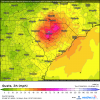
Anybody got the pretty, yet unreliable, wind gust map from the Euro? This looks fun.....

Webberweather53
Meteorologist
Elsa is hobbling along right into landfall.
@Shaggy @Downeastnc @WeatherNC if these latest model trends hold, Elsa may spare y'all from those tropical rains that you surely don't need.
Shaggy
Member
@Shaggy @Downeastnc @WeatherNC if these latest model trends hold, Elsa may spare y'all from those tropical rains that you surely don't need.
I've always been more concerned of squalls and tornado threat here. Despite all the rains the river has returned to normal or a little below normal levels.
FamouslyHot
Member
Yeah I think I'll stick with the GFS on this storm...Anybody got the pretty, yet unreliable, wind gust map from the Euro? This looks fun.....
View attachment 86257
Attachments
I forget about weather.us and yeah, the Euro has lost it's freaking mind LolYeah I think I'll stick with the GFS on this storm...

Shaggy
Member
These maps are garbage. I refuse to entertain them.
Blue_Ridge_Escarpment
Member
12Z Early tropical models are west again...right up into east Charlotte/Matthews/Fro AreaMost guidance right now is still East up central NC.
Downeastnc
Member
@Shaggy @Downeastnc @WeatherNC if these latest model trends hold, Elsa may spare y'all from those tropical rains that you surely don't need.
Luckily its fast moving we dont need a lot of rain on the headwaters....ground here is pretty dry, ditches have emptied etc..... actually have not had much rain the last week or so....I want to see some kind of jet enhancement to give us some decent winds but probably wont even get that.
Downeastnc
Member
These maps are garbage. I refuse to entertain them.
These are like that one model that always had the insane snow maps ( DGEM maybe ) always way overdone...
blueheronNC
Member
Didn’t Brad Panicovich guarantee not a drop from this?12Z Early tropical models are west again...right up into east Charlotte/Matthews/Fro Area
Blue_Ridge_Escarpment
Member
Essentially. 95 and East only. Aged like mayonnaise outside in the summer.Didn’t Brad Panicovich guarantee not a drop from this?
Not a hurricane model, but that aNAM tho!
Brad Namovitch
Brad Namovitch
Shaggy
Member
Not a hurricane model, but that aNAM tho!
Brad NamovitchView attachment 86260
It carries her way up.due north into Georgia. I think we will know by this evening if she is turning more NNE or staying more due north. Will likely be a nowcasting scenario.
So far the 12z Hrrr starts that turn just over the Georgia state line so its much sooner than the 3k
Not a hurricane model, but that aNAM tho!
Brad NamovitchView attachment 86260
The NAM has been persistent with a westerly track since yesterday. I don't know how much I trust it though... But it hasn't budged.
Shoot us a video when that yellow comes rolling through Hallifax countyAnybody got the pretty, yet unreliable, wind gust map from the Euro? This looks fun.....
View attachment 86257
bigstick10
Member
Probably coming right up through GA to ATL then Northeastward
FamouslyHot
Member
I would never advise going with the NAM for a tropical system, especially when it goes way against NHC guidance.The NAM has been persistent with a westerly track since yesterday. I don't know how much I trust it though... But it hasn't budged.
That being said, we may see some more slight west shifts before all is said and done.
I’ll take euro wind gusts for 1000 please!
Jesus this thing looks more impressive in the Carolinas than it does at landfall .. this could maybe cause some actual issues .. not 80 mph gust issues but the HRRR gusts are approaching 40-50 mph here and they are fanning out as well 

Regardless of where this goes (I still think probably between Charlotte and Raleigh) those outer bands on the north and east side of the storm are going to bring a tornado threat .. I would be interested to see what the experimental tornado outlook looks like that someone in here posts some times that thing is oddly spot on a lot of the timeNot a hurricane model, but that aNAM tho!
Brad NamovitchView attachment 86260
Unfortunately I do think y’all see decent tropical outer and rains at the least similar to what the HRRR is spitting out .. luckily you are right that this thing is a fast mover and lack of rain past few days means this shouldn’t be too terrible but tropical systems are always trickyLuckily its fast moving we dont need a lot of rain on the headwaters....ground here is pretty dry, ditches have emptied etc..... actually have not had much rain the last week or so....I want to see some kind of jet enhancement to give us some decent winds but probably wont even get that.
?
Looks like the euro op run was west of the EPS but still it's a shift west.

Downeastnc
Member
HRRR track would be interesting here, wind gust 45-50 for most of NC east of I 95 for 4-5 hrs tomorrow afternoon.....not sure how overdone that may be but the setup with the gradient etc could be enough to make those wind speeds doable.
Avalanche
Member
Not sure why people think this is a weak hurricane. The Weather Channel said Elsa was unleashing its fury on Florida with damaging flooding and winds.
Yep somewhere between Charlotte and Raleigh looks about right