accu35
Member
Fwiw Nam is west. Is this possible?

Thanks man, that's why i posted the 18z Nam "FWIW" but the birdman called me out on it ??
Elsa coming in a tad stronger than this morning on this recon mission ~1005 hPa, but not any stronger than it was yesterday.
This is what mby needs!! Instead it will be east and I will have sinking dry air.Models shifted inland track west, @SD special right there
View attachment 86164
View attachment 86165
Throw back to when I said Elsa could bring much needed rain for us last week and I was stoned and shamed ? again still not a for sure thing but looks like we will at least get SOMETHINGModels shifted inland track west, @SD special right there
View attachment 86164
View attachment 86165


They were only recent runs of some models so WPC won’t usually change those rainfall maps based on sudden changes … if we get a few more cycles like the ones recently then I’m sure those totals will rise with timeI saw the optimistic rainfall forecasts for central NC in the posts above but then I saw this tweet this morning from Brad P indicating basically zero. Thoughts?
I saw the optimistic rainfall forecasts for central NC in the posts above but then I saw this tweet this morning from Brad P indicating basically zero. Thoughts?

That’s BRad P for you! Ride or die with each model run! Get a better met in your life, like Matthew East, that guy from Shelby, hell, even Birdman is more accurateI saw the optimistic rainfall forecasts for central NC in the posts above but then I saw this tweet this morning from Brad P indicating basically zero. Thoughts?


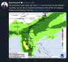
This is why GSP point forecasts for CLT metro has gone against the WPC and is very different from what Brad P is throwing out there. I’ve said it before, these TC’s always have their heaviest precip to the north and west of the center as they come further inland. If there is much more in the way westward shifts on the models, we may start to see a favorable upslope for the mountains to get heavy rain.Great setup Thursday with divergence and shear vector promoting a northwest-of-track precip max across the Piedmont. Green light special.
View attachment 86179
Don’t tell the MEANerator ?? but ukmet joins the party View attachment 86182
I would say that’s pretty good honestly but the HWRF did correct pretty quickly to a lower type system .. I think honestly when you get land interaction with the shredder islands it throws a lot of wrenches in many models performancesSo how would we break down model handling up till this point?
I think the gfs did best on genesis and track but ran mostly too strong in the Caribbean.
The euro did poorly with everything except the desheviled disrupted storm in the Caribbean but that was mostly due to land interaction though.
Hwrf is out to lunch on strength......it had a cat 3 at this point which isnt even close.
Am I close?

That's not good.I was just about to say this but I’m glad he did so I don’t have to be accused of “weenie wishcasting” it ??
Never said it was. Again just saying the possibility is there for the occurrence.That's not good.