• Hello, please take a minute to check out our awesome content, contributed by the wonderful members of our community. We hope you'll add your own thoughts and opinions by making a free account!

Tropical TS Elsa

Not to give a prediction yet but I think if you're in the southeast (especially Georgia, SC, NC) you maybe getting some significant rainfall from this if we keep the western shifts up. Personally I think from Biloxi to the western panhandle of florida looks prime for a landfall before pushing Northeast over the carolinas and then OTS.
 
Not to give a prediction yet but I think if you're in the southeast (especially Georgia, SC, NC) you maybe getting some significant rainfall from this if we keep the western shifts up. Personally I think from Biloxi to the western panhandle of florida looks prime for a landfall before pushing Northeast over the carolinas and then OTS.
The good news is that it should be moving pretty quick.
 
Not to give a prediction yet but I think if you're in the southeast (especially Georgia, SC, NC) you maybe getting some significant rainfall from this if we keep the western shifts up. Personally I think from Biloxi to the western panhandle of florida looks prime for a landfall before pushing Northeast over the carolinas and then OTS.
This has been my feeling on this since yesterday. I’m just not sure I can buy into these tracks out to sea on this yet until we would see more modeling trying to come north over Hispaniola. Even on the Euro, the center goes over over the western tip of the island
 
So we have the gfs/Canadian with a big hit and the Euro, UK, Icon with nothing. I'll side with the latter trio until they go toward the gfs/cmc
Models have a westerly bias , they like to push the storms to far to the left of guidance if I am not mistaken . I’m betting it trends east , also I saw someone say it would strengthen and that would mean more westward motion, however isn’t the opposite true ? A stronger storm wants to curve NE more than a weaker storm .
 
So we have the gfs/Canadian with a big hit and the Euro, UK, Icon with nothing. I'll side with the latter trio until they go toward the gfs/cmc
Well damn. Ya just looked at the euro and it basically does say no shot in hell it makes to gom. If this was moving slower maybe, but that door is wide ass open for a wide right miss.
 
Models have a westerly bias , they like to push the storms to far to the left of guidance if I am not mistaken . I’m betting it trends east , also I saw someone say it would strengthen and that would mean more westward motion, however isn’t the opposite true ? A stronger storm wants to curve NE more than a weaker storm .
I said it could go more west because the ridge was building in (stronger upper ridge vs weaker low level flow) but doesn’t seem to be the case now.
 
I said it could go more west because the ridge was building in (stronger upper ridge vs weaker low level flow) but doesn’t seem to be the case now.
Thanks for clarifying. Euro really tears this up it looks , no chance of redevelopment after Hispaniola ?
 
Models have a westerly bias , they like to push the storms to far to the left of guidance if I am not mistaken . I’m betting it trends east , also I saw someone say it would strengthen and that would mean more westward motion, however isn’t the opposite true ? A stronger storm wants to curve NE more than a weaker storm .
Generally yes stronger will want to punch into a ridge and eat away but if you have a weird case where upper level ridging is stronger it might bend it farther west. I think some of the ones in 2005 Rita maybe trended left as they got stronger. There is another that I can't remember anymore that the models just kept chasing left over time and it had a decent SW component to its movement
 
Well damn. Ya just looked at the euro and it basically does say no shot in hell it makes to gom. If this was moving slower maybe, but that door is wide ass open for a wide right miss.
Yeah the Euro is killing it as soon as it crosses the islands then the mountains finish the job. There is a good amount of shear north of the islands so I'm guessing that is why the Euro is killing it off. Even the CMC that has a US hit is really weak through the Caribbean.
 
So we have the gfs/Canadian with a big hit and the Euro, UK, Icon with nothing. I'll side with the latter trio until they go toward the gfs/cmc
It is interesting isn't it, one of them is wrong lol

1625167536268.png
 
So we have the gfs/Canadian with a big hit and the Euro, UK, Icon with nothing. I'll side with the latter trio until they go toward the gfs/cmc
This also could be a case where the European type models don’t handle tropical systems as well as American models … obviously we will see how everything shakes out but someone’s losing this match big time
 
I would also point out that the Hurricane models are on the side of the American models .. which I wouldn’t really want to go away from a model made specifically for tropical systems
Isn’t this storm in the Long range for hurricane models ? I would imagine at the range this storm is on those models they wouldn’t have a good grip just yet.
 
  • Like
Reactions: SD
I'm just not sure i'm buying the northern shift as hard as the Euro is selling it. Look at the 850 steering.

Strong Westerly flow on top of, and in front of the cyclone. [24hr]

1625171455153.png

and yet it still jogs north? [48 hr]

1625171526629.png

That ridge nose is still present, with decent westerly flow north of the cyclone. I'm just not buying the angle of northern turn on the Euro
 
Ruuude
@NickyBGuarantee did you read @SD link or did you ignore it because it doesnt satisfy your weenie fantasies? Read before disliking my post, which had hard facts. Truth hurts sometimes. If the models were opposite and it was the Gfs showing it getting tore apart and heading ots you would find a way to bash the Gfs and crown the euro.
 
...ELSA STILL MOVING RAPIDLY WEST-NORTHWESTWARD...
...TROPICAL STORM WATCH ISSUED FOR PORTIONS OF HAITI...


SUMMARY OF 500 PM AST...2100 UTC...INFORMATION
----------------------------------------------
LOCATION...11.2N 53.8W
ABOUT 410 MI...660 KM ESE OF BARBADOS
ABOUT 520 MI...835 KM ESE OF ST. VINCENT
MAXIMUM SUSTAINED WINDS...45 MPH...75 KM/H
PRESENT MOVEMENT...WNW OR 285 DEGREES AT 29 MPH...46 KM/H
MINIMUM CENTRAL PRESSURE...1005 MB...29.68 INCHES
New advisory:
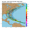
New track:
205258_5day_cone_with_line_and_wind.png
 
New advisory:
New track:
205258_5day_cone_with_line_and_wind.png
Same general overall idea when looking at the past few advisories. Obviously the NHC seems to be favoring the more western solutions that go into the Gulf. I certainly wouldn’t bet against those forecasters. All in all, they’ve done a really good job on forecast tracks the last few years, even a few days out. The only one that I can really recall them completely whiffing was Irma….which just kept correcting further west
 
Hasn’t the Euro done pretty bad on tropical systems lately. Right now I don’t see it going out to sea without a USA likely Florida landfall


Sent from my iPhone using Tapatalk
 
I'm just not sure i'm buying the northern shift as hard as the Euro is selling it. Look at the 850 steering.

Strong Westerly flow on top of, and in front of the cyclone. [24hr]

View attachment 86004

and yet it still jogs north? [48 hr]

View attachment 86005

That ridge nose is still present, with decent westerly flow north of the cyclone. I'm just not buying the angle of northern turn on the Euro

Euro looks to be dead on on motion in both of those images
 
6 to 8 days away from LF, depends where it hits. The storm hasn't even made it to the Caribbean yet so plenty plenty of time for a different track. Fun times ahead.
 
View attachment 86015

GFS starting to show signs of slowing the trough. Leaving the door slightly ajar for OTS..?
It would need to slow it down a good bit more than than that. That set up would most likely be a track right up the Florida west coast and into the Big Bend area. As the trough pulls away it could also slow the forward speed down significantly as it comes into the southeast. This is something that is a worry this time of the year with troughs not dipping as far south as we see in the fall. The trough will be enough to pull it north, but if the storm gets left behind, then you end with a storm overland just spinning itself out and dumping tons of rain.
 
Back
Top