Nothing to see here. Just a standard 70+dbz core ?.


ZCZC SPCPWOSPC ALL
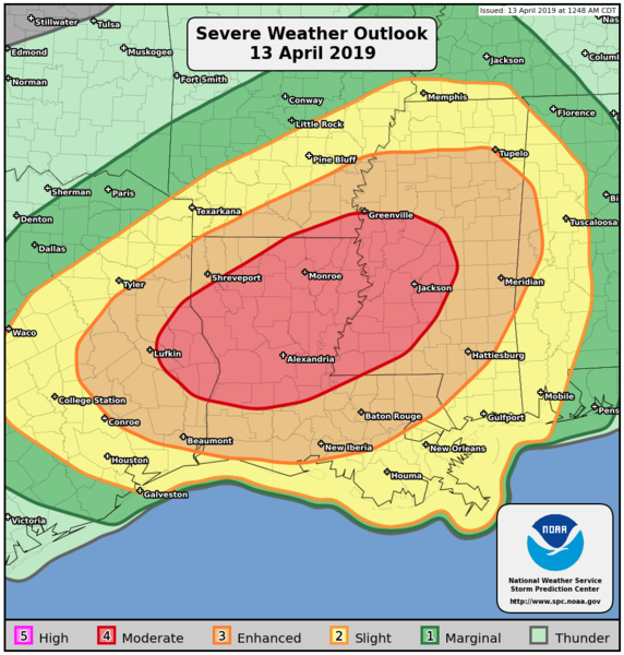
WOUS40 KWNS 130742
ALZ000-ARZ000-LAZ000-MSZ000-TXZ000-131800-
PUBLIC SEVERE WEATHER OUTLOOK
NWS STORM PREDICTION CENTER NORMAN OK
0242 AM CDT SAT APR 13 2019
...Severe thunderstorms expected over parts of the East Texas to
lower Mississippi Valley region later today and tonight...
* LOCATIONS...
Central and northern Louisiana
Mississippi
East Texas
Southern Arkansas
Western Alabama
* HAZARDS...
Several tornadoes, a few intense
Widespread damaging winds
Scattered large hail, some baseball size
* SUMMARY...
Numerous severe thunderstorms capable of producing tornadoes,
wind damage and large hail, are expected across parts of east
Texas, Louisiana, southern Arkansas, Mississippi, western
Alabama and surrounding areas today and tonight. The greatest
risk is from east Texas to central Mississippi.
Preparedness actions...
Review your severe weather safety procedures for the possibility
of dangerous weather today. Stay tuned to NOAA Weather Radio,
weather.gov, or other media for watches and warnings. A tornado
watch means that conditions are favorable for tornadoes to form
during the next several hours. If a tornado warning is issued for
your area, move to a place of safety, ideally in a basement or
interior room on the lowest floor of a sturdy building.
&&
..Edwards.. 04/13/2019

It looks like a nightmare.
Isn't a tornado really just some "damaging winds"? I think I will stick with the SPC on this one thank you.New AFD from Blacksburg mentions the latest guidance having way more clouds for western NC. Good news for anyone rooting against a real “enhanced risk” event. But still some severe around with damaging winds.

Dry as a bone here! Missed by about 25 miles or so!Waking up to rain and louuud thunder, welp today is the day, hope and pray for our Freinds down in Louisiana/Texas for no loss of life or damage
We have had a lot of rain here over the last 2 days. Ground is soaked.Dry as a bone here! Missed by about 25 miles or so!
It rained like hell here this morning. Might have been some hail at onset here at my house. Cell just went boom right on top of meDry as a bone here! Missed by about 25 miles or so!

Has any mesosclae discussions or watches started in LA?


I would make a guess that north Georgia could go moderate tomorrowThe new NAM has STPs in GA now peaking at 7 and 8 in places.
I would make a guess that north Georgia could go moderate tomorrow


By the time it progresses to near the Triangle, it should be in linear mode and thus reduce the tornado threat somewhat. Definitely should be sufficient cape and shear for convection with winds and at least some tornado threat.Really looking like a significant threat for much of the SE now
What does the pink mean??The new NAM has STPs in GA now peaking at 7 and 8 in places.