Happy to see temps tempering back closer to average but as a whole the days 2-7 period is underwhelming as far as cool air east of the apps. Any front passage is quickly replaced by return flow so our cool days are likely due to clouds and rain chances not true dry/cool air. As we get out to D7 and beyond we might have a better chance to drive cool and dry deeper in the region but for the most part these day 7+ troughs on the models have flattened in time or been weak with cool weather
-
Hello, please take a minute to check out our awesome content, contributed by the wonderful members of our community. We hope you'll add your own thoughts and opinions by making a free account!
You are using an out of date browser. It may not display this or other websites correctly.
You should upgrade or use an alternative browser.
You should upgrade or use an alternative browser.
Pattern September 2023 Discussion Thread
- Thread starter SD
- Start date
By looking at the forecast lows, I can tell that dewpoints will still be higher than I would like. This cooldown is not going to be bringing any of those cool, crisp autumn days when temperatures get into the upper forties and lower fifties at night. It is welcome relief however from highs in the upper nineties and surpassing 100 as the temperature did yesterday.Happy to see temps tempering back closer to average but as a whole the days 2-7 period is underwhelming as far as cool air east of the apps. Any front passage is quickly replaced by return flow so our cool days are likely due to clouds and rain chances not true dry/cool air. As we get out to D7 and beyond we might have a better chance to drive cool and dry deeper in the region but for the most part these day 7+ troughs on the models have flattened in time or been weak with cool weather
- Joined
- Jan 23, 2021
- Messages
- 4,604
- Reaction score
- 15,202
- Location
- Lebanon Township, Durham County NC
One buck again at RDU
In fairness it’s still a tad early for that nice crisp air to be regular. I know my average temperatures are still 86/64. Like you said though it will be nice to see 90s go away for awhileBy looking at the forecast lows, I can tell that dewpoints will still be higher than I would like. This cooldown is not going to be bringing any of those cool, crisp autumn days when temperatures get into the upper forties and lower fifties at night. It is welcome relief however from highs in the upper nineties and surpassing 100 as the temperature did yesterday.
Drizzle Snizzle
Member
Yeah but it's not unheard of to get the first crisp airmass in Mid September, although it's usually in Late September i believe.In fairness it’s still a tad early for that nice crisp air to be regular. I know my average temperatures are still 86/64. Like you said though it will be nice to see 90s go away for awhile
As I have said before and will say again, I am skeptical about some of the readings that come from the RDU airport station these days. Living here my entire life, Fayetteville and Charlotte almost always were warmer than Raleigh with their temperature readings. It's been strange seeing Raleigh's temperatures being anywhere from two to five degrees warmer than these cities on average the past couple of years. I know the developers and builders have taken away a lot of the trees from the Triangle area and replaced them with concrete and asphalt but that shouldn't have affected temperatures that much. The same story when it comes to development is happening in Charlotte.One buck again at RDU
Last edited:
RDU once again hitting 100 and my room hitting 81 (with the AC running)
Brent
Member
Looking good ?
BHS1975
Member
RDU once again hitting 100 and my room hitting 81 (with the AC running)
Yeah it's jacked.

Sent from my iPhone using Tapatalk
Better hope the next trough forecasted to show up in 7 days isnt a MIA.Happy to see temps tempering back closer to average but as a whole the days 2-7 period is underwhelming as far as cool air east of the apps. Any front passage is quickly replaced by return flow so our cool days are likely due to clouds and rain chances not true dry/cool air. As we get out to D7 and beyond we might have a better chance to drive cool and dry deeper in the region but for the most part these day 7+ troughs on the models have flattened in time or been weak with cool weather
MichaelAndrews
Member
- Joined
- Jan 23, 2021
- Messages
- 4,604
- Reaction score
- 15,202
- Location
- Lebanon Township, Durham County NC
I know there’s several Durham folks here. There’s now an official identifier for the Duke Helipad(KTQV) and an obs page to match:
Really impressive severe thunderstorm here for September… 1.03” of rain with some penny size hail.
Winner winner chicken dinner  ️
️ 
️ I’ve picked up over an inch in the last hour and still hammering. Keeps backbuilding. Big boomers out the window.
Tarheel17
Member
I'll be moving to <2 miles from the RDU observation site early next year. Guess I'll need to invest in a good personal weather station to provide real-time validation of the readingYeah it's jacked.

Sent from my iPhone using Tapatalk
That was a lot of rain..
accu35
Member
I known we are fixed on Lee atm, but my local forecast is showing fall weather starting tonight and definitely next week with lows in the upper 50s. I’m thankful
NoSnowATL
Member
Are you still in South AL ?I known we are fixed on Lee atm, but my local forecast is showing fall weather starting tonight and definitely next week with lows in the upper 50s. I’m thankful
Drizzle Snizzle
Member
Even South AL could be flirting with upper 50s late next week.Are you still in South AL ?
accu35
Member
I amAre you still in South AL ?
BHS1975
Member
Had a beefy storm earlier with pea sized hail and 60mph gusts. Cooled it down to 71F.
Sent from my iPhone using Tapatalk
Sent from my iPhone using Tapatalk
HugeSnowStick
Member
Beautiful 76 degrees.
Getting slammed with dime size hail
Unless something changes in the day10 plus range, summers over y’all.
JHS
Member
No higher than about 85-86 here through day 7. Yesterday may have been our last day of 90+ for a while. Not ready to say those days are done until next year just yet, but things are looking better.Unless something changes in the day10 plus range, summers over y’all.
W
WSW
Guest
Rough night in the Western suburbs of DC.
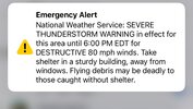
Severe Weather Statement
National Weather Service Baltimore MD/Washington DC
609 PM EDT Fri Sep 8 2023
VAC059-107-153-082245-
/O.CON.KLWX.SV.W.0333.000000T0000Z-230908T2245Z/
Loudoun VA-Fairfax VA-Prince William VA-
609 PM EDT Fri Sep 8 2023
...A SEVERE THUNDERSTORM WARNING REMAINS IN EFFECT UNTIL 645 PM EDT
FOR SOUTHEASTERN LOUDOUN...NORTHWESTERN FAIRFAX AND NORTHWESTERN
PRINCE WILLIAM COUNTIES...
At 608 PM EDT, a severe thunderstorm was located over Brambleton,
moving northeast at 10 mph.
HAZARD...Golf ball size hail and 60 mph wind gusts.
SOURCE...Trained weather spotters. Numerous reports of wind driven
hail have been reported across southern and eastern Loudoun
County, mainly up to half dollar size hail. Hail up to golf
ball size is possible.
IMPACT...Expect wind damage to trees and power lines. Hail is large
enough to dent and damage vehicles. Some hail damage to
roofs, siding, and windows is possible.
Locations impacted include...
South Riding, Herndon, Broadlands, Lansdowne, Lowes Island,
Brambleton, Dulles International Airport, Ashburn, Sterling,
Chantilly, Countryside, Arcola, Belmont, and Sterling Park.
Picked up 1.02 quick hard hitterGetting slammed with dime size hail
- Joined
- Jan 23, 2021
- Messages
- 4,604
- Reaction score
- 15,202
- Location
- Lebanon Township, Durham County NC
Storm split the house tonight. Looks like it rained pretty good to the SW near Bennett Point and to the east over 501.
Brent
Member
Thursday ? winter is coming

Drizzle Snizzle
Member
How do you have a high of 68 and a low of 62 ? I could understand if it was cloudy and rainy but with mostly clear skies ? Maybe that was an error and its supposed to say 78 and not 68 ?Thursday ? winter is coming
View attachment 136946
Brent
Member
How do you have a high of 68 and a low of 62 ? I could understand if it was cloudy and rainy but with mostly clear skies ?
I dunno but it's wrong about Monday too which has high rain chances
Edit looking at the GFS it has widespread rain all day which yeah that would make more sense
Last edited:

accu35
Member
62 this morning

Monsoons all around . Cant mow,ballgames in an out of tstorm delays.
Drizzle Snizzle
Member
Nice and cool in the midwest and interior northeast. Normal to above for the deep south and gulf coast it looks like.
- Joined
- Jan 23, 2021
- Messages
- 4,604
- Reaction score
- 15,202
- Location
- Lebanon Township, Durham County NC
Seems like Winston is the only place you can play right nowMonsoons all around . Cant mow,ballgames in an out of tstorm delays.
- Joined
- Jan 23, 2021
- Messages
- 4,604
- Reaction score
- 15,202
- Location
- Lebanon Township, Durham County NC
Still seeing lightning bolts south of Carter-Finley
As long as that next disturbance over Sampson County doesn't fire up we should be goodStill seeing lightning bolts south of Carter-Finley