Snowflowxxl
Member
4/5/17 is my comparison for this event for now.
CAMs coming into range and they look like the 3km NAM View attachment 40081View attachment 40082


View attachment 40067
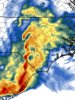
The latest 0z NAM sounding shows PDS Tornado sounding for Dallas/FW.
.jpg")
Yeah this one still has potential to be big, all it takes is a shift in the MCS miles north to setup a pseudo warm front in areas like N AL/GA into NC, or ofc it can go the other way and go south like the NAM shows, but where this MCS begins slowing down and trains, is likely where the boundary will setup and storms will form along it/south of it, sorta similar to the last system which was a MCS View attachment 40085View attachment 40086
Agree.. If that MCS does not form, AL/GA and even into SC are going to see the event escalate quickly.At this point I could see this go either way. This could get ugly quick. IMHO, at this point, you better hope for a MCS or something to choke out the upper parts of the region. I think the MCS is the less likely situation right now.
Yeah this one still has potential to be big, all it takes is a shift in the MCS miles north to setup a pseudo warm front in areas like N AL/GA into NC, or ofc it can go the other way and go south like the NAM shows, but where this MCS begins slowing down and trains, is likely where the boundary will setup and storms will form along it/south of it, sorta similar to the last system which was a MCS View attachment 40085View attachment 40086
At this point I could see this go either way. This could get ugly quick. IMHO, at this point, you better hope for a MCS or something to choke out the upper parts of the region. I think the MCS is the less likely situation right now.


Agreed, but its interesting to see the models still do not have a consistent grasp on this system. Tomorrows short range runs will tell us so much more!Just a bit of information, the RAP performed the worst by far of the short range models the last event.
Agreed, but its interesting to see the models still do not have a consistent grasp on this system. Tomorrows short range runs will tell us so much more!
No worries!Just adding a tidbit on its performance.

The RAP was absolutely horrible with the northern extent of the last events warm sectorLong range RAP most likely is overdoing things substantially, but at first glance it seems to be siding with the Nam right now.View attachment 40068


Yes! They were dead in last time in their threat categories.. and very fine forecasters fir that matter... not to take anything away from SPC, but BMX has a better handle seems due to them knowing their area and how things react in the past... hoping BMX is right again!This probably got posted this morning but NWS Birmingham didn't seem too enthused. Appreciate that they don't always follow the SPC map exactly. They typically have a good idea of what to expect...
"This lead impulse will greatly impact the prospects for severe weather from the late morning into the afternoon on Thursday. Models have trended a bit slower with the 500 mb trough and surface low which could allow for greater refocusing along the cold front. The 12 km NAM is very bullish with eye-popping parameters based on an idealistic scenario, the kind that rarely seem to verify. At this time, this has a low probability of occurring, but if it does, a significant tornado threat would be on the table. Many times the 12 km NAM`s convective scheme
minimizes the impact of the lead impulse, and this could very well be case in this situation. The most likely scenario is for morning storms to result in an effective warm front across the middle of our area, with veered surface winds across the warm sector. However, substantial instability is likely to develop by early afternoon across the warm sector, with CAPE of 2500-3500 J/kg and strong 0-6 km shear in place. Storm initiation will depend on how much low-level convergence can develop behind the morning storms. Any storms in this environment will be capable of producing damaging winds, large hail, and perhaps a tornado."
View attachment 40087
They didn't really seem too enthusiastic about it being a non event either atleast from the afd this morning. You can really tell that the models have been giving them fits over the last couple of weeks.Yes! They were dead in last time in their threat categories.. and very fine forecasters fir that matter... not to take anything away from SPC, but BMX has a better handle seems due to them knowing their area and how things react in the past... hoping BMX is right again!
The HRRR isn’t even showing isolated storms. The morning mess diminishes the threat almost entirelyIt’s a isolated severe threat! I think it will be the morning rain. Followed by isolated severe storms of course a isolated tornado is possible.
Sent from my iPhone using Tapatalk


.png")
.png")

