• Hello, please take a minute to check out our awesome content, contributed by the wonderful members of our community. We hope you'll add your own thoughts and opinions by making a free account!

Possible Severe Weather April 22nd-23rd

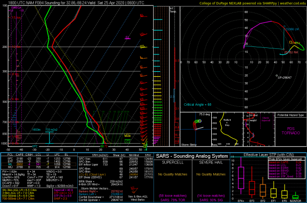
Yeah I’ll pass on these soundings near my area, please, no, almost the exact look as Easter with a plume of cape that comes from the western Atlantic/eastern Gulf of Mexico with the LLVL jet, just not as far north 6BC6322D-0CDB-4734-B4CC-5E98D26263C4.png65AE8160-4113-4D2C-B767-61FC3EB229AD.png
 
Even with the quality of the NAM, it already shows broken up supercells in the QLCS, wow 3D5197CC-AC57-4DBE-B49A-331C67E4293D.png
 
Guess were never gonna get a break, based on these models is this gonna be worse than the past 2 event we just had?
 
Cannot post right now, but in reading AFD's so far FFC is Bullish, while BHM is a bit more "bearish" putting more effect in the morning storms and not rebounding to higher unstable values
 
This event has really escalated quickly it feels like.
I'm seeing a trend here lately that due to the current situation where global models are currently struggling because they are lacking critical data from aircraft. Seems like we aren't really able to nail down a threat until it gets 3-4 days out.
 
Well for all of us guys in west and central GA that talk about how storms always roll through at night, here we go. From early signs it could be the Auburn to Columbus to LaGrange areas in the cross hairs.
 
Well for all of us guys in west and central GA that talk about how storms always roll through at night, here we go. From early signs it could be the Auburn to Columbus to LaGrange areas in the cross hairs.

Yeah, if the NAM's right, this one's going to hit us right at peak heating.

EDIT: That being said, the other models are several hours faster (suggesting a morning event), although they're trending in the NAM's direction.
 
Perhaps one saving grace with this setup is that there looks to be a lot more drier air aloft.

This is a good thing in that it should help to limit storm coverage, but it could also mean a higher intensity for the storms that do develop.
 
Perhaps one saving grace with this setup is that there looks to be a lot more drier air aloft.

This is a good thing in that it should help to limit storm coverage, but it could also mean a higher intensity for the storms that do develop.

Basically looks like a dry line setup you see on the Great Plains, those more frequently feature discrete, isolated supercells, and the potential for strong tornadoes increases with said storm mode.
 
Basically looks like a dry line setup you see on the Great Plains, those more frequently feature discrete, isolated supercells, and the potential for strong tornadoes increases with said storm mode.

Yeah, this would be the setup to watch for those strong, long-tracked tornadoes and also prolific hailers.
 
Yeah, this would be the setup to watch for those strong, long-tracked tornadoes and also prolific hailers.

We're pretty fortunate that we may not have a ridiculous amount of CAPE to work w/ given the trough over New England that's pumping cool/stable air into much of the upper south the day before this event in addition to prefrontal convection in the warm advection regime that may suppress the warm front (at least temporarily) further to the south.

Obtaining adequate CAPE appears to be the primary limiting factor w/ this event, even into the afternoon on Thursday, the 3km NAM shows very little, if any MUCAPE in GA & the Carolinas. Later on in the evening & overnight, this could change however. Very curious to see how the environment looks beyond this point on the next few runs of the NAM.

1587472805317.png
1587472788003.png
 
We're pretty fortunate that we may not have a ridiculous amount of CAPE to work w/ given the trough over New England that's pumping cool/stable air into much of the upper south the day before this event in addition to prefrontal convection in the warm advection regime that may suppress the warm front (at least temporarily) further to the south.

Obtaining adequate CAPE appears to be the primary limiting factor w/ this event, even into the afternoon on Thursday, the 3km NAM shows very little, if any MUCAPE in GA & the Carolinas. Later on in the evening & overnight, this could change however. Very curious to see how the environment looks beyond this point on the next few runs of the NAM.

View attachment 39991
View attachment 39990

FWIW, the next few frames of the 12k NAM does show significant instability building northward towards BHM and ATL late Thursday Afternoon / Thursday evening, behind the prefrontal activity.
 
NAM has overestimated the extent of the WF the last few events. Don’t be surprised if that continues here...

On the other hand, with a negative tilt trough and sub-1000mb low way up into Kentucky, a warm front would have an easier time moving northward despite mesoscale influence from CAD and morning convection.
 
Gotta hand it to BMX on the severe outlook in the last event... the guy that hand drew the map showing the cooler stable event and the worst staying Montgomery south... they got it right... SPC... and I’m not bashing them... but they kept us in a hatched moderate when it clearly wasn’t going to happen. I’m hoping BMX is right again! They do have some top notch forecasters there!!
 
Gotta hand it to BMX on the severe outlook in the last event... the guy that hand drew the map showing the cooler stable event and the worst staying Montgomery south... they got it right... SPC... and I’m not bashing them... but they kept us in a hatched moderate when it clearly wasn’t going to happen. I’m hoping BMX is right again! They do have some top notch forecasters there!!

Difference here however may be that the convection clears during the late overnight hours or morning, giving ample time for destabilization and lateral expansion of the warm sector.
 
Back
Top