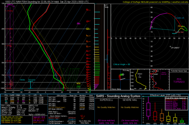
• Hello, please take a minute to check out our awesome content, contributed by the wonderful members of our community. We hope you'll add your own thoughts and opinions by making a free account!

Possible Severe Weather April 22nd-23rd

Unless I read it wrong at no point does the 3knam even give me a severe sounding whereas the 12k gives me a tornado sounding as the broken line moves through in the dark in the night yay.

Yeah that's what confuses me. It's a huge difference up here in GSO. Obviously I would like the 3k to be the one to verify...
 
One thing I could see put a damper on a high end threat is really the lack of directional shear with height. Seeing if they back will be my focus the next day or so.

crossover.us_se.png
 
I’m assuming the NAM 3km/NAM 12km look different is because the NAM 12km looks a tad bit more amped and less flat meaning it can pull in better warm sector/SBcape , but still that’s a pretty big difference, especially for areas on the northern side, basically go from high end soundings on the NAM 12km to elevated storms on the 3km 5CA885BD-2E4B-4414-A1A5-E05D33E5CFBF.png7116B970-1529-4E1A-B07A-C9EFB894B642.png
 
hopefully this will be more south of ATL like last event, at this rate im gonna need to invest in a storm shelter lol
 
So, in order to get an MCS along the GC, I always thought you would need to have a low pressure farther south? Since the better dynamics are closer to the LP. I could be way off.
 
I’m assuming the NAM 3km/NAM 12km look different is because the NAM 12km looks a tad bit more amped and less flat meaning it can pull in better warm sector/SBcape , but still that’s a pretty big difference, especially for areas on the northern side, basically go from high end soundings on the NAM 12km to elevated storms on the 3km View attachment 40041View attachment 40042

That sucks because those differences are what seperates us NC folk from a nothingburger to potential night time tornado hazard.
 
I’ve noticed the severe events are not trending north just yet this spring which is good for us in NC/VA. It’s been frosty and cool with more 30s tomorrow. Maybe we can hold off until spring severe season transitions to Canada when the jet is much further north.
 
I got a question how often does dry lines make it to alabama? I can only remember one time and that was april 27th 2011. Is it rare for this to happen?
 
I’ve noticed the severe events are not trending north just yet this spring which is good for us in NC/VA. It’s been frosty and cool with more 30s tomorrow. Maybe we can hold off until spring severe season transitions to Canada when the jet is much further north.
From what I am reading we may need to be on the lookout in NC/SC this coming Saturday/Sunday. Euro is showing a setup that could get pretty nasty. Still lots of time to trend in the other direction though.
 
Back
Top