Storm5
Member

Sent from my iPhone using Tapatalk
Yippie
Sent from my iPhone using Tapatalk

Sent from my iPhone using Tapatalk
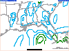
12z 3km NAM just collapses the line before BHM and is pretty much is a none event for all of AL except for NW AL and a pocket or two.
The 12z WRF-ARW shows the line staying pretty stout but has completely given up on any significant convection ahead of the QLCS.
So far the 3km NAM is nailing the ragged appearance of the line.
Sun is shining in Shelby countyJust stepped outside and I swear I could smell the gulf! That ain't good...
 and its 71+°
I'm going to stick with the HRRR in my opinion it's best for the hours before the storm , again this is my personal opinion
Sent from my Pixel 2 using Tapatalk
 9
9My goodness. Tds as wellView attachment 30305

You have they spin up as quick as they go away. ?Have I mentioned here how much I hate QLCS tornadoes. I think so.
Here is why you cannot just equate higher surface temps to more severe weather. The models have slowly adjusted higher surface temps with the stronger WAA, but the flip side is it has also advected warmer air at 925mb and 850mb, effectively hurting both low level lapse rates and 3km Cape. So far low level lapse rates have been very well forecasted by the NAM, 3km NAM and Euro. Add in high shear and linear forcing and you have what we have right now.


.gif")