gawxnative
Member
My peak gust was 37.. earlier Non T storm gust was 41 so.. yeah it "died" about ATL itself for this segment of the line
That’s good news to hear...Typical Georgia storms. Weakened line moves across state as daylight ends. Got some rain and a few rumbles.
I know you didn’t even ask lol, but I Give myself a C+, kinda fell into the HRRRs trap of supercells firing out ahead of the line, even if it did have support, hrrr is very known to do that, overall unidirectional flow nearly to the SFC and flow parallel to system made this more of a wind eventI give myself a B+. I underestimated the overall coverage of the wind and I was seriously believing there would be an elevated tornado threat in SE AL. All in good fun. That is the first event I've followed from start to finish in years.
I'll use it as a crutch when I absolutely bomb the next one.
I know you didn’t even ask lol, but I Give myself a C+, kinda fell into the HRRRs trap of supercells firing out ahead of the line, even if it did have support, hrrr is very known to do that, overall unidirectional flow nearly to the SFC and flow parallel to system made this more of a wind event


This thing is really ramping up in the upstate..wow..I’m behind the line now but damn that was a dicey couple of minutes


UnderstatementIts windy


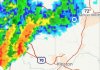
Tornado Warning for Cumberland and Hoke county in North Carolina. Downtown Fayetteville is included in the warning.View attachment 30432