Right, but the overall synoptic setup really isn’t very supportive of a storm, really not a awesome H5 setup, and really not a great push of cold. I think the best we see is a ZR chance for the mountains. We would need to see huge shifts, and we haven’t seen that lately especially since we’re at a point where the storm is on land, and getting worse.One set of 18z runs is not a reason to give up on a storm. That is beyond pessimistic. You need to have it go in the wrong direction at least 3-4 runs in a row to start throwing this one away
-
Hello, please take a minute to check out our awesome content, contributed by the wonderful members of our community. We hope you'll add your own thoughts and opinions by making a free account!
You are using an out of date browser. It may not display this or other websites correctly.
You should upgrade or use an alternative browser.
You should upgrade or use an alternative browser.
Ostrich December
- Thread starter SETNwx
- Start date
NBAcentel
Member
Members
Looks like a lot more ice to rain to me, vs the snow/sleet they were showing earlier, honestly it wouldn’t shock me if areas around 85/north pick up some freezing rain, then we switch over to rain, something similar to that one November 2019 setup
Looks like a lot more ice to rain to me, vs the snow/sleet they were showing earlier, honestly it wouldn’t shock me if areas around 85/north pick up some freezing rain, then we switch over to rain, something similar to that one November 2019 setup
Attachments
-
 3383EED3-4429-4C57-9630-870BF552FCA7.png212.4 KB · Views: 33
 -
 5BEBDFAF-8AD6-4E5D-9CF9-97BAE910A8CD.png227.3 KB · Views: 32
 -
 413ED63B-F39D-483C-9FCB-94A9E2038C0D.png216 KB · Views: 33
 -
 5F5A3AD9-F181-45DB-B96C-D026F6CC50A6.png225.9 KB · Views: 32
 -
 B2D77859-F244-4145-A77A-39B78AD403C0.png230.6 KB · Views: 28
 -
 9A173F6B-0053-49C5-9BED-DFAC068EF915.png228.4 KB · Views: 27
?
NBAcentel
Member
On the NAM the same thing is happening, energy in SW farther slightly farther south, and that energy in central Canada further south but the main soon to be 50/50 isn’t as good
Clem282340
Member
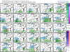
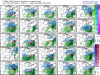
So it not looking good for a winter stormOn the NAM the same thing is happening, energy in SW farther slightly farther south, and that energy in central Canada further south but the main soon to be 50/50 isn’t as goodView attachment 57126
Over land or not we know a lot can change in 5 days. We are still in the game. ?
you can’t predict a winter storm from the NAM 5 days out. It’s better short range like 24 hours. Euro is typically good at this range need it to continue to strengthen cad like most recent run.So it not looking good for a winter storm
The “highway” to Madison, about 30 min out of DBQ @ 2 pm
I can’t remember the last time (if) we got a surprise where we went from modeled rain to snow. I think that every single surprise went from a little snow, to a lot of snow. January 2000, 2018, December 2010 for example. I wouldn’t hold my breath on this one if we’re routing for a southern trend.
iGRXY
Member
I don’t think anyone should’ve been expecting snow from this regardless. Freezing rain and sleet and mostly freezing rain was always going to be the likely scenario and that is still very much in play.
NBAcentel
Member
Icon looks better already 
L
Logan Is An Idiot 02
Guest
Oh yeah for sure. Once it trends rain it doesn't trend backI can’t remember the last time (if) we got a surprise where we went from modeled rain to snow. I think that every single surprise went from a little snow, to a lot of snow. January 2000, 2018, December 2010 for example. I wouldn’t hold my breath on this one if we’re routing for a southern trend.
Sent from my Pixel 3 using Tapatalk
NBAcentel
Member
I think jan 2016 several models had rain/freezing rain but it ended up trending colder and had more IP insteadI can’t remember the last time (if) we got a surprise where we went from modeled rain to snow. I think that every single surprise went from a little snow, to a lot of snow. January 2000, 2018, December 2010 for example. I wouldn’t hold my breath on this one if we’re routing for a southern trend.
YepI think jan 2016 several models had rain/freezing rain but it ended up trending colder and had more IP instead
Attachments
iGRXY
Member
CAD generally trends colder. Especially when it comes to Ice. One thing I’m noticing is models trying to run out LP into the CAD and that just isn’t going to happen. Seen that happen too many times just for it to trend back to more ice from 72 hrs inI think jan 2016 several models had rain/freezing rain but it ended up trending colder and had more IP instead
Yeah, but that happens with most every major Miller B setup. ZR is always way over modeled, and ends up being mostly sleet. December 2018 did that, and I think February 2014 did as well. Altogether in those setups, they had a very decent shot of winter precip. I just feel like we’re teetering between ZR and Rain.I think jan 2016 several models had rain/freezing rain but it ended up trending colder and had more IP instead
Blue_Ridge_Escarpment
Member
Yeah the LP is going to travel the path of least resistance and that isn’t right up in the middle of cold air.CAD generally trends colder. Especially when it comes to Ice. One thing I’m noticing is models trying to run out LP into the CAD and that just isn’t going to happen. Seen that happen too many times just for it to trend back to more ice from 72 hrs in
You are correct. In fact until within 36 hours out, CLT was expected to get predominantly rain, but the NAM really caught on to the strength of the wedge and the colder thermals the day before and the metro area ended up with a major sleet stormI think jan 2016 several models had rain/freezing rain but it ended up trending colder and had more IP instead
NBAcentel
Member


iGRXY
Member
Most likely scenario is the LP is going to move around the CAD and transition to the coast. The lows never make it above I20 before they transition. Now I will say if you’re expecting snow, that’s just likely not going to happen. The Euro from today’s 12z run had 850’s running around 43 degrees but did have 925s slightly below freezing so you could see some sleet but ZR is likely what we are going to see. Precip isn’t very heavy either but a good .6 - .9 looks possible which could really create some issues.Yeah the LP is going to travel the path of least resistance and that isn’t right up in the middle of cold air.
L
Logan Is An Idiot 02
Guest
Looks like the hp is further south to me?
Sent from my Pixel 3 using Tapatalk
NBAcentel
Member
ICON colder this run and has a close-to (don’t know if this is enough QPF to be considered one) ice storm for areas around 85 and northwest 

iGRXY
Member
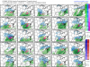
Knock off the warm bias temperatures by even 3-4 degrees and that is a very significant ice storm.ICON colder this run and has a close-to (don’t know if this is enough QPF to be considered one) ice storm for areas around 85 and northwest View attachment 57133View attachment 57134
NBAcentel
Member
ICON has been consistent on this freezing rain setup....
I wish there were a jealous reaction!
I don't think I've ever experienced a total sleet storm with nothing else... I think it would be coolYou are correct. In fact until within 36 hours out, CLT was expected to get predominantly rain, but the NAM really caught on to the strength of the wedge and the colder thermals the day before and the metro area ended up with a major sleet storm
Van Denton posted it nicely, the odds shifted down 2% from yesterday based on the mean of ensembles for areas near the Greensboro NC airport. I highly recommend reading his Facebook post and how he calculates percentages each day. Looks like ice but it never takes much to drop the snow out of Virginia into western North Carolina when the cad continues to strengthen every run. We simply don’t know. After today tho, a few of us need to quit cliff diving after each set of runs thinking it’s a trend.
Especially for central NC. You had maybe a few ensemble members here or there showing some sleet but that's about it. This really is only a snow threat for the mountains. Still could be interesting though!I don’t think anyone should’ve been expecting snow from this regardless. Freezing rain and sleet and mostly freezing rain was always going to be the likely scenario and that is still very much in play.
NBAcentel
Member
Ruh roh, and normally the icon is warm by a few degrees 
That January 2016 had just a little bit of ZR with it... just enough to make nearly 3 inches of sleet on the ground a rock hard glacier... the kids had some really good sledding in that oneI don't think I've ever experienced a total sleet storm with nothing else... I think it would be cool
Clem282340
Member
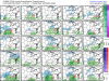
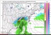
Looks like ga is getting colder as wellRuh roh, and normally the icon is warm by a few degrees View attachment 57135
iGRXY
Member
I’ve seen where it’s stated the ICOn can run 4-7 degrees too warm generally and globals are awful with the depth of CAD and the strength of it so it wouldn’t be at all out the possibility to see the Piedmont and Upstate running around 29-33 degrees here.Ruh roh, and normally the icon is warm by a few degrees View attachment 57135
Keep in mind that to get a real ice storm, you need to have upper 20’s. These ice setups are usually overestimated/overhyped, when we have temps at freezing. There’s the stronger CAD argument, but there really isn’t any point in getting hyped, unless we get something considerable into the NAM range.
NBAcentel
Member
Keep in mind that to get a real ice storm, you need to have upper 20’s. These ice setups are usually overestimated/overhyped, when we have temps at freezing.
32 degree ZR = tree ice event
iGRXY
Member
And these models already have us at 33-35 degrees right now. It would likely be running 29-31 as of today. CAD always trends colder so upper 20’s is a real possibility here. Like I said earlier, another thing that overhypes the ZR is we get these 2-3 inch events that the models show as all ZR. This is going to be a much lighter falling precip with the storm goal around 3/4 quarters of an inch of liquid that would be falling more like a shower. That can really help with the accrual of ice.32 degree ZR = tree ice event
I live on the east facing slopes of the blue ridge it takes alot for an ice storm I will say that seen a many. My chainsaw has the scars to prove it you really need temps below 32° to get any serious accumulation. I highly doubt this system produces much unless your on up the road toward Virginia.
I’ve always thought that as well, but I did a little bit of research and found that during the infamous 1973 Atlanta Ice Storm, temperatures stayed in 30-32 degree range throughout. Heck even IMBY during the January 2017 winter storm, I saw over a 1/4 inch of ice accrual with a temperature of 31-32.Keep in mind that to get a real ice storm, you need to have upper 20’s. These ice setups are usually overestimated/overhyped, when we have temps at freezing. There’s the stronger CAD argument, but there really isn’t any point in getting hyped, unless we get something considerable into the NAM range.
I would dial it back. Ignore the Icon warm bias, because most other models agree with it just barely being into freezing north of I-85. Not a real good push of cold air to get an ice storm IMO. I’ve been burned so many times being around 32-33 degrees while the CMC says I get .50 inches of ice. If anybody gets anything outside of maybe a light coating, it’ll be maybe Winston-Salem northwestward. There’s the potential CAD trend, but don’t count on that happening, because it’s easy to get too excited. I have an extremely hard time seeing up in the upper 20’s, it’s just not that strong of climo setup. I could be wrong though.And these models already have us at 33-35 degrees right now. It would likely be running 29-31 as of today. CAD always trends colder so upper 20’s is a real possibility here. Like I said earlier, another thing that overhypes the ZR is we get these 2-3 inch events that the models show as all ZR. This is going to be a much lighter falling precip with the storm goal around 3/4 quarters of an inch of liquid that would be falling more like a shower. That can really help with the accrual of ice.
True, but those highs were just locked in place and just didn’t go away. This is a receding high, so temps are going to warm up.I’ve always thought that as well, but I did a little bit of research and found that during the infamous 1973 Atlanta Ice Storm, temperatures stayed in 30-32 degree range throughout. Heck even IMBY during the January 2017 winter storm, I saw over a 1/4 inch of ice accrual with a temperature of 31-32.
iGRXY
Member
And I’ve seen these models consistently under perform CAD here all my life. I’ve seen them try to drive LP directly into CAD and that just isn’t going to happen. It never does. CAD always over performs, always gets colder the closer you get to show time, and for the globals to be that close to freezing already tells me an ice storm is looking more and more likely. On top of that you only get those ridiculous ice totals from models showing every bit of liquid being freezing rain. No matter if it’s falling very heavy. That’s not the setup here. You’re dealing with lighter precip that lasts over a longer period of time, if it’s as modeled. Now I’m not saying an inch of ice but .25-.5 certainly couldn’t be ruled out.I would dial it back. Ignore the Icon warm bias, because most other models agree with it just barely being into freezing north of I-85. Not a real good push of cold air to get an ice storm IMO. I’ve been burned so many times being around 32-33 degrees while the CMC says I get .50 inches of ice. If anybody gets anything outside of maybe a light coating, it’ll be maybe Winston-Salem northwestward. There’s the potential CAD trend, but don’t count on that happening, because it’s easy to get too excited. I have an extremely hard time seeing up in the upper 20’s, it’s just not that strong of climo setup. I could be wrong though.