Blue_Ridge_Escarpment
Member
I think we’ve broke the models. 18Z NAM hasn’t even initiated yet. 75 mins late.
Yes that's true. I do remember now it being plenty cold at the start of that storm. At H5 it's relatively similar with the AK vortex. I'm not sure why it was so much colder. I remember it being in the mid 20s at onset IIRC.


Many here can attest to the fact that sun angle means everything.The irony is that while we don’t have as much cold air available as we would in January and February. We also are approaching the shortest days of the year as well the angle being the lowest it gets. You’d think we’d be able to muster up something this month.
Sent from my iPhone using Tapatalk
I mean I'm not sure we would necessarily have more cold air available in Jan or Feb than on Dec 11. For example, in Atlanta the average high is warmer on Feb 11 than it is on Dec 11. And it's only 3 degrees colder on Jan 11 than it is now.The irony is that while we don’t have as much cold air available as we would in January and February. We also are approaching the shortest days of the year as well the angle being the lowest it gets. You’d think we’d be able to muster up something this month.
Sent from my iPhone using Tapatalk
Yeah, I had 4 inches from that “pre event” which was the first of 3 consecutive days of 3 or more inches of daytime snowfall for me and that was a ton of sleet during the middle of the main storm. I had more snow those 3 days than I’ve seen in the 6+ years since.Wild "pre event" to the bigger storm that came 12-18 hours later. That little event overperformed big time for areas that didn't end up getting much at all with the next storm.


Not as bad as you think taken verbatim. Snow can eat away at ice totals. Sleet can eat away at both. Same for cold rain. If it trends colder then could be looking at more issues.That would be a freaking mess.
The first half of February 2014 really was a beast. Notice the insane ridging north of AK.Considerably more snow & ice cover over N America & the CONUS leading up to that event, preventing more modification of the oncoming air mass(es).
View attachment 57072
It's mid-February, the source region (arctic) is usually colder at that time of the year than during December due to greater land and sea snow/ice mass and cooler adjacent oceans (where sea ice isn't present). Another thing to keep in mind is that an arctic air mass that reaches us in the 2nd week of February usually starts moving towards the mid-latitudes several days prior (early February near their climo temp mins), whereas this one started over the Arctic in early December when it's typically much warmer.
Take Barrow, Alaska's temperature trace as an example, notice their climo temperature min doesn't come until late January at the earliest, and it's usually colder in February than it is in December (one reason why we tend to do better snowfall-wise in Feb vs Dec despite similar mean climo temps here).
View attachment 57073

Not as bad as you think taken verbatim. Snow can eat away at ice totals. Sleet can eat away at both. Same for cold rain. If it trends colder then could be looking at more issues.

Yeah that was a intense -WPO which funneled some super cold airThe first half of February 2014 really was a beast. Notice the insane ridging north of AK.View attachment 57079
True but it did trend a bit colder this run in the immediate CAD areas. Also, held the CAD a bit longer. I expect to see that trend to continue too per usual.Icon is one of the worst solutions if you want winter weather to, yet still has some ZR in cad regions


easy!.....About 30 min out of Dubuque, roads covered! Sketchy as hell driving!
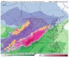
Looks like just west of GSO/Forsyth is the place to be. BIRDMAN from Wilkes might be in good position.

True, the first wave providing the warm nose went further north. The main coastal wave is further south. ?We’ll see where this goes but on the GFS the HP appears 2 mb weaker than 12Z

Confluence still trending better on 18z GFS View attachment 57084
Yeah it’s a battle right now. GFS/ICON vs Euro/CMC with the NAM joining in later tomorrow.Hopefully this is not the start of something that’ll trend worse, icon/gfs look similar here
You know it's gonna trend worse. Always does.Hopefully this is not the start of something that’ll trend worse, icon/gfs look similar here
Also, I’d argue that the GFS ensembles dont agree with the OP so we have that in our camp depending on 18ZHopefully this is not the start of something that’ll trend worse, icon/gfs look similar here


Miller B means Miller Screw for us.If others charge for this information and you give it for free, I still want my money back.
BTW, the EURO still looks like 33F and rain here. It would be nice if this thing could go all Miller A on us!