It’s winter storm watch criteria setup for mtns and foothills. But piedmont could see a splattering of snow/sleet to ice too. ESP Winston Salem region
-
Hello, please take a minute to check out our awesome content, contributed by the wonderful members of our community. We hope you'll add your own thoughts and opinions by making a free account!
You are using an out of date browser. It may not display this or other websites correctly.
You should upgrade or use an alternative browser.
You should upgrade or use an alternative browser.
Ostrich December
- Thread starter SETNwx
- Start date
Correct me if I’m wrong, but isn’t the Euro usually a few degrees too warm at this lead time when it comes to CAD. If that’s so, then most of the NC Piedmont and northern SC upstate would be in playEuro was actually shockingly close to a big ice storm, temps around 34/33View attachment 56824
Give me the the-NAO combo any day. It sucks watching the Mid Atlantic cash in over and over, but we have a better shot in the long range if it holds. Is a -EPO and-NAO together not possible? It's been so long since we've had a -NAO I cant remember.Would you rather have a -EPO with a +NAO/+AO with 50/50 lows that escape out due to no blocking orrrr a +EPO/-NAO/-AO thats often warmer
euro does well but NAM does best on thermals 1-2 days out. CMC is always overdone inngore.Correct me if I’m wrong, but isn’t the Euro usually a few degrees too warm at this lead time when it comes to CAD. If that’s so, then most of the NC Piedmont and northern SC upstate would be in play
Webberweather53
Meteorologist
It’s hard to get both -NAO and -EPO simultaneously because the wave fluxes that create both patterns destroy one or the other unless they’re accompanied by a strong -AOGive me the the-NAO combo any day. It sucks watching the Mid Atlantic cash in over and over, but we have a better shot in the long range if it holds. Is a -EPO and-NAO together not possible? It's been so long since we've had a -NAO I cant remember.
Thats what I was thinking. History shows a better shot of a cold and stormy pattern with the -NAO I think? So I'll take my chances. If we can hold it the deeper we go into winter that should help.It’s hard to get both -NAO and -EPO simultaneously because the wave fluxes that create both patterns destroy one or the other unless they’re accompanied by a strong -AO
iGRXY
Member
All models are generally too warm with CAD except mesoscale from a day or so out. They generally trend colder and stronger and models always want to drive Low Pressure directly into CAD and it never happens. Also places in the northern upstate often go from a ZR nightmare on the models to actually getting a lot of sleet with backend ZR. Generally because the CAD is strong and the WAA is less due to the LP having to deviate around the CAD and not coming so far inland.Correct me if I’m wrong, but isn’t the Euro usually a few degrees too warm at this lead time when it comes to CAD. If that’s so, then most of the NC Piedmont and northern SC upstate would be in play
Webberweather53
Meteorologist
-NAOs afford us a better chance to get coastal cyclones, always a big risk involved that we’re just handing off our threats to the mid Atlantic and NE US in this kind of pattern though. If we manage to get a persistent and strong -NAO with multiple storms to lay down some good snow cover to our north then things can changeThats what I was thinking. History shows a better shot of a cold and stormy pattern with the -NAO I think? So I'll take my chances. If we can hold it the deeper we go into winter that should help.
- Joined
- Jan 5, 2017
- Messages
- 3,805
- Reaction score
- 6,058
That verifies every year! I've grown to like it. Saves me money!
any prime cad location is in play (Georgia-South Carolina). Several days away a lot could Happen. Different days and different storms. Usually we fail the first few times until we build snow pack over mid Atlantic then we lock it in.
yep para gfs was about to do it. Low over Florida but looked like it could slide on east and bomb off the s/e.it will happen future runs me thinks.-NAOs afford us a better chance to get coastal cyclones, always a big risk involved that we’re just handing off our threats to the mid Atlantic and NE US in this kind of pattern though. If we manage to get a persistent and strong -NAO with multiple storms to lay down some good snow cover to our north then things can change
D
Deleted member 609
Guest
The bird ate his wheaties today
NBAcentel
Member
I just realized the euro/EPS shows this behind the miller B 

This is only the GFS, not sure what the Euro has. But until we get the stubborn MJO to not want to hang on the right of the circle in winter we'll struggle to get cold. It may want to head to ph 7 but who knows? I also see just as many wanting to loop right back to crap in 4 and 5. The NAO is saving our ass from torching right now but can't supply the cold we need. The Pac has to be somewhat favorable..
What does this relate to in laymen terms?I just realized the euro/EPS shows this behind the miller B View attachment 56844View attachment 56845
Looks decent. - NAO, low heights in the 50/50, but that look out west probably won't allow it to be cold enough.I just realized the euro/EPS shows this behind the miller B View attachment 56844View attachment 56845
NBAcentel
Member
Some other peice of energy wants to dig after the miller B system, and there’s possibly some major snowpack to our north, but idk bout that western ridge looks mehWhat does this relate to in laymen terms?
Repost this image daily until April. No need to bother with going to the site.View attachment 56843
This is only the GFS, not sure what the Euro has. But until we get the stubborn MJO to not want to hang on the right of the circle in winter we'll struggle to get cold. It may want to head to ph 7 but who knows? I also see just as many wanting to loop right back to crap in 4 and 5. The NAO is saving our ass from torching right now but can't supply the cold we need. The Pac has to be somewhat favorable..
NBAcentel
Member
Exactly what I was thinking, kinda want something better for digging toLooks decent. - NAO, low heights in the 50/50, but that look out west probably won't allow it to be cold enough.
B
Brick Tamland
Guest
As far as the NAO and ENSO go, I always like to show this every winter for NC folks from the NC Climate Office.
Our results found that a negative NAO combined with a positive ENSO phase (El Niño) resulted in the most snow days on average, with an increase of 25% (or more) in snow days for all four winter months.
A positive NAO combined with a negative ENSO (La Niña) resulted in the greatest decrease in average snow days. This is due to a lack of cold air (results of a typical positive NAO), and less active subtropical jet stream (results of a typical La Niña).
NAO had the most significant impact on snow days. Even in winter months that featured La Niña conditions (typically warm and dry), combined with a negative NAO, only February saw a decrease in snow days, which suggests that the NAO has a more direct influence on NC snowfall than ENSO. The reason behind this is that the NAO directly impacts the large scale atmospheric pattern over the eastern U.S. on a daily timescale, whereas the ENSO pattern indirectly effects the eastern U.S. atmospheric pattern by altering global circulations, and does so on monthly to seasonal timescales.

Yeah that patten is way better than previous years and just a taller western ridge from being good. But that look verbatim still won't get it.Some other peice of energy wants to dig after the miller B system, and there’s possibly some major snowpack to our north, but idk bout that western ridge looks meh
tennessee storm
Member
The pacific is killing us be honest it looks like crapLooks decent. - NAO, low heights in the 50/50, but that look out west probably won't allow it to be cold enough.
Blue_Ridge_Escarpment
Member
18Z NAM looks quite a bit different at hour 63 with that energy diving down for system #1
NBAcentel
Member
As much as the PAC sucks, we can still work with a -NAO
Example

Example
Nope just a few cliff divers here from one day of models when the same people they pay for says to watch out. I’m keeping the discussion going because I see cad potential too.The bird ate his wheaties today
NBAcentel
Member
That’s the spirit ?Nope just a few cliff divers here from one day of models when the same people they pay for says to watch out. I’m keeping the discussion going because I see cad potential too.
Most models overdo temps in CAD situations to some degree, especially the globals. It seems like the NAM is usually best (it’s also best at sniffing out warm noses, IMO).Correct me if I’m wrong, but isn’t the Euro usually a few degrees too warm at this lead time when it comes to CAD. If that’s so, then most of the NC Piedmont and northern SC upstate would be in play
Biggest difference I see is a better 50-50 low in 2010 and now we have ridging there.As much as the PAC sucks, we can still work with a -NAO
Example View attachment 56846View attachment 56847
NBAcentel
Member
Biggest difference I see is a better 50-50 low in 2010 and now we have ridging there.
True, it’s adjustable tho, I wanna bet over the next few days we’re gonna have several Debbie downer runs and good runs for that miller B System and something after perhaps, given we’re entering a nice -NAO, problem is, Will they stick around and happen ? Lol
Keep Christ in Christmas like faith in snow. Please like if you agree and keep winter storm tracking through Christmas. Don’t let the same few keep you from discussing the weather here. Enjoy expert analysis from webb and others. Pay me no mind I just try to speak the truth.
Thank you. I was thinking that the Euro specifically was a little warm in CAD situations. In fact I can remember that the January 2016 storm, the Euro had me getting very little in the way of onset ice and temperatures would then stay above freezing most of the storm. The NAM however had me a few degrees colder with temperatures staying in the upper 20s and me getting a predominately sleet event which aside from a little snow at the beginning and end is what happened.Most models overdo temps in CAD situations to some degree, especially the globals. It seems like the NAM is usually best (it’s also best at sniffing out warm noses, IMO).
Yeah I think we may see some fantasy storms show up here and there. Hopefully this pattern holds. Even 2010 didn't produce until Christmas and then in early Jan. 2011. I don't even want to think about it if we haven't scored by mid Jan this year.True, it’s adjustable tho, I wanna bet over the next few days we’re gonna have several Debbie downer runs and good runs for that miller B System and something after perhaps, given we’re entering a nice -NAO, problem is, Will they stick around and happen ? Lol
The dews in the NE are what you are looking for

and the wind has veered around to the NNE

But youd really like to see the 1026 isobar down into NC not in Pa and the wedge doesn't have a ton of depth to it likely on from the sfc to 950 if that. In many locations that will be quickly eroded from the top down by precipitation and WAA on SE winds then even further warmed by any freezing since the cold dry feed is so weak.

Realistically with the parent low travelling into the Ohio Valley it becomes difficult for this to be anything but a primarily ZR/RN event for the Carolinas since the tendency will be to flip winds from 950 S. If you want more IP or a shot at SN you will need the primary low and shortwave to trend weaker or south. This might be enough to veer winds in the 925-700 layer more E or NE and hold in some cold longer.
and the wind has veered around to the NNE
But youd really like to see the 1026 isobar down into NC not in Pa and the wedge doesn't have a ton of depth to it likely on from the sfc to 950 if that. In many locations that will be quickly eroded from the top down by precipitation and WAA on SE winds then even further warmed by any freezing since the cold dry feed is so weak.
Realistically with the parent low travelling into the Ohio Valley it becomes difficult for this to be anything but a primarily ZR/RN event for the Carolinas since the tendency will be to flip winds from 950 S. If you want more IP or a shot at SN you will need the primary low and shortwave to trend weaker or south. This might be enough to veer winds in the 925-700 layer more E or NE and hold in some cold longer.
Last edited:
You can see the isobars bending (cad) on the old para gfs run even with the storm missing us. I would imagine if we had precip it would be even stronger bending of isobars on para. It’s coming if moisture comes.The dews in the NE are what you are looking for
and the wind has veered around to the NNE
But youd really like to see the 1026 isobar down into NC not in Pa and the wedge doesn't have a ton of depth to it likely on from the sfc to 950 if that. In many locations that will be quickly eroded from the top down by precipitation and WAA on SE winds then even further warmed by any freezing since the cold dry feed is so weak.
Realistically with the parent low travelling into the Ohio Valley it becomes difficult for this to be anything but a primarily ZR/RN event for the Carolinas since the tendency will be to flip winds from 950 up south of the S. If you want more IP or a shot at SN you will need the primary low and shortwave to trend weaker or south. This might be enough to veer winds in the 925-700 layer more E or NE and hold in some cold longer.
NBAcentel
Member
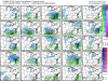
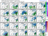
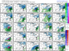
Here’s some scenarios for you curious folks
Attachments
-
 0EABF6BB-BDAF-45DC-BDD3-3E7657576A8B.png211.3 KB · Views: 66
 -
 F0B3570D-B1A1-4DDA-B92F-0895139E2C56.png210.7 KB · Views: 64
 -
 E9E4EE59-F2E9-4540-993B-9EB51701527D.png216 KB · Views: 59
 -
 4F8C7DDC-1CD0-462E-8ADE-A798877F71CE.png221.6 KB · Views: 59
 -
 DEB337BF-7FC0-4C5B-BCA3-27EA4CAB1875.png222.5 KB · Views: 59
 -
 2F503A27-39CA-4F5D-A7F1-A6CF8B8559CD.png221.5 KB · Views: 48
Some good news, the weeklies snow mean was the highest I’ve seen the entire winter!!

I love when you send the ensembles out like this! Good perspectiveHere’s some scenarios for you curious folks
Congrats FLORIDASome good news, the weeklies snow mean was the highest I’ve seen the entire winter!!
View attachment 56859
Iceagewhereartthou
Member
Hope can be a wonderful thing my friend, just be careful of hearbreak! ?This has got to be the year that we get a big snowstorm come up through Atlanta and Upstate SC. One that you don’t even have to worry about the I-85 rain/snow line. It’s just gotta be time. I believe.
Yeah I've heard the same thing from peeps from Columbia SC for years saying they're due. Unfortunately Mother Nature doesn't care. However the last 2 -NAO years CAE and all the upstate cashed in. Unfortunately we don't know if this is even going to be a -NAO year yet.Hope can be a wonderful thing my friend, just be careful of hearbreak! ?