Brent
Member
Finally some rain maybe... But check out next week ?

Was under the blanket didn't even make it below 50Crappy phone pic I know but that cloud deck was slow to move in here, temp dropped to 39.7, actually 37 at the airport, while other locations were in mid to upper 40s under that blanket.
View attachment 122900
Cozy under the blanket here . I’d rather no blanket though and some more sunshineCrappy phone pic I know but that cloud deck was slow to move in here, temp dropped to 39.7, actually 37 at the airport, while other locations were in mid to upper 40s under that blanket.
View attachment 122900
Yeah, the NBM has been going drier and drier for the midweek front. Looking at like 1/4 inch at best (at this point). Models really backing off on the infusion of tropical moisture getting involved.Models trending drier later this week. The Euro is now .25 or less for many of us.

.png")

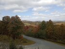
We're probably 7-10 days away from peak foliage around my neck of the woods which is 10 days early and probably 2 weeks ahead of the past few years.I believe fall color around here could be the best it has been in quite some time. Lots of sunny days and cool crisp nights in the 40s .. excited since I’m already seeing color changes!
Yeah we're running well above average in the foothills too. I'm building a house up in blowing rock I'll take some pics later this week.We're probably 7-10 days away from peak foliage around my neck of the woods which is 10 days early and probably 2 weeks ahead of the past few years.
My wife commented tonight about how little green is left. A lot of russets and yellows but the maples are still holding back. Im color blind so I have to rely on her with some of them.Yeah we're running well above average in the foothills too. I'm building a house up in blowing rock I'll take some pics later this week.
My wife commented tonight about how little green is left. A lot of russets and yellows but the maples are still holding back. Im color blind so I have to rely on her with some of them.

You are so close. Any day now. HaGot down to 63, no frost yet.

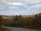
Appreciate the pictures I'll be up there this weekend nice to see it hasn't gotten too far past peak yet.I wish I had a better camera sorry guys.
Yeah man you'll be in good shape for sure. EnjoyAppreciate the pictures I'll be up there this weekend nice to see it hasn't gotten too far past peak yet.
Yep

@Brent 12z GFS with the first fantasy snow of the season for us at day 10. LolView attachment 122923
Front Early next week should be able to whip up severe. Gonna get a temp spike 24-36 hrs ahead of its approach. One would think with that clash coming, fireworks would be present.Any chance of severe weather in the southeast tomorrow?


What elevation is your house being built at? Congrats on living in the most beautiful area, along with the most Perfect wx Climate imo. You get the best of all 4 seasons and still get to live in the southYeah we're running well above average in the foothills too. I'm building a house up in blowing rock I'll take some pics later this week.
Aho Gap I'm building the house I work for a contractor only in my dreams could I afford or pay 4M but it sits at 3800ft. We got another home at the top that sits at 4000. So I'll definitely have some obs this winter.What elevation is your house being built at? Congrats on living in the most beautiful area, along with the most Perfect wx Climate imo. You get the best of all 4 seasons and still get to live in the south