NoSnowATL
Member
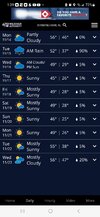
39. ?
22???

what's this source? I'm not doubting and I just want to check it out.

 .
.
looks like the southeast will be a battleground between cool and warm.

I bottomed out at 29.7F just after midnight, but then the wind shifted to the northeast and there was a ton of warmer air surrounding lake Lanier. I was up to 33F by morning.25.3 here. The breeze never completely quit.

This winter is showing signs that it might be +TNH heavy, while it doesn’t mean it’ll be 100% of the time, imo there’s gonna be a supply of cold air this year like last year and there may be awkward North Pacific blocking which allows the southeast ridge to flex, but then there might be times where the cold makes it to the southeast (this week for example). Also day 10+ is prone to a -NAO. I show +anoms right there for the SE but there might be periods where it gets pretty cold, that average doesn’t mean it’ll be near average the whole time, it means more variable/changing temps but I lean on a little warm since it’s easier to be warmer in the SESe ridge? Looks legit.
Sent from my iPhone using Tapatalk
.png")
Did you buy @Rain Cold 's rain shield for the frozen variety?Never thought our first snow threat ends up like this ? View attachment 123837
snow chase to Elk City ?Never thought our first snow threat ends up like this ? View attachment 123837
And now they just put this out. Not sure I buy it though, but we will see.
12Z NAM was a banger, for what I’ve got to work withNever thought our first snow threat ends up like this ? View attachment 123837


Looks like that's at the higher elevations (like Boone). And here's Boone's grid forecast (...a true winter type forecast):Where's Wilkes?
Tomorrow All Models Show this.
Agreed… I’m really starting to see signs that this is just going to be very much an up and down season with regards to temperatures in the southeast. Things will probably still average out to be slightly above when all is said and done… for example November will still be above average after these next 7-10 days. It’s odd because these type of fluctuations in temperatures is more reminiscent of a neutral ENSO… certainly not like a typical LaNina. One thing is for sure… even during the warmer periods, as long as that SE Canada vortex keeps hanging around, there will be plenty of CAD. I know I’ve said this the last number of years, but southern NC Piedmont is way overdue for a major ice storm… this could be the overall pattern that creates itThis winter is showing signs that it might be +TNH heavy, while it doesn’t mean it’ll be 100% of the time, imo there’s gonna be a supply of cold air this year like last year and there may be awkward North Pacific blocking which allows the southeast ridge to flex, but then there might be times where the cold makes it to the southeast (this week for example). Also day 10+ is prone to a -NAO. I show +anoms right there for the SE but there might be periods where it gets pretty cold, that average doesn’t mean it’ll be near average the whole time, it means more variable/changing temps but I lean on a little warm since it’s easier to be warmer in the SE


Woohoo I'm back in Pittsburgh are till wednesday...would love to see it!12Z NAM was a banger, for what I’ve got to work withView attachment 123840View attachment 123839

Depressing!That’s de ja vu to last late December View attachment 123841View attachment 123842
Not really, that sort of pattern eventually favors a cold shot/high pressure to build into Mongolia/China and +EAMT which would act to eventually extend the pacific jetDepressing!