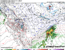
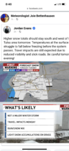
As much as I would love an early season novelty event.. I think there’s too many factors that need to go absolutely right for us to see snow. It’s just a bit too early for us. The cold attack will be impressive but I don’t think things align for us on this one.
-
Hello, please take a minute to check out our awesome content, contributed by the wonderful members of our community. We hope you'll add your own thoughts and opinions by making a free account!
You are using an out of date browser. It may not display this or other websites correctly.
You should upgrade or use an alternative browser.
You should upgrade or use an alternative browser.
Pattern November 2022
- Thread starter RBR71
- Start date
- Status
- Not open for further replies.
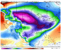
I for one would love to see that! That happens to be my birthday and I've checked that data for RDU on the day I was born and the high that day was 41 degrees and the low was 25 degrees on that day over fifty years ago. The record low for my birthday is 18 degrees and I remember that day back in the mid 1980s too because me and some friends had a chilly camping trip that weekend. If those temperatures were with some accumulating snow, I'd be golden. There has never been any measurable snow at RDU on my birthday and that's something I'd like to live to see.This would be impressive imo for late NovemberView attachment 123804
Last edited:
Drizzle Snizzle
Member
Best of luck to you. I hope you get your birthday wish.I for one would love to see that! That happens to be my birthday and I've checked that data for RDU on the day I was born and the high that day was 47 degrees and the low was 25 degrees on that day over fifty years ago. The record low for my birthday is 18 degrees and I remember that day back in the mid 1980s too because me and some friends had a chilly camping trip that weekend. If those temperatures were with some accumulating snow, I'd be golden. There has never been any measurable snow at RDU on my birthday and that's something I'd like to live to see.
All that’s true. One thing that does look good is the cold push. Thermals really do look good, it’s just going to be a matter of getting enough moisture and high enough rates. Definitely a long shot, but at least it’s something to watchAnother big thing is going to be some front end FGEN similar to the storm from January. There likely will be more moisture and front end thump of some kind if we can maintain the S/W. At this point, cold and suppressed is good as long as we can keep the storm. I still wouldn’t expect anything more than a few hours of snow that may cover the grass before melting but that’s great for November.
Darklordsuperstorm
Member
Brent
Member
BufordWX
Member
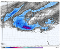
Looks like dry air further north and east really kills off the precipitation field as it moves further east. Hrrr has been consistent so far in showing the heavier snow accumulation in the west and then south of I-40.Trending the wrong way for snow here. I guess I'll go back to hoping I see some flakes like typical November. I'm sure we'll have better chances when winter actually arrives for real View attachment 123810
However, I wouldn’t give up hope just yet. A last second northward trend with the precipitation field would be a game-changer and I would watch model trends later today. Whoever gets under the heaviest band tomorrow will likely get hammered.
olhausen
Member
Low here was forecast for 24-25 but I bottomed out at 30 degrees. It’s 39 now which is still impressive for November 13th at noon.Temps here haven’t dropped in two hours, looks like the forecasts are to low. This cold is a very slow bleed.
Low here was forecast for 24-25 but I bottomed out at 30 degrees. It’s 39 now which is still impressive for November 13th at noon.
Agreed. I was forecast 29F, but only hit 32F. I'm still hovering at 42.8F.
LickWx
Member
Forecasts for boone , Nashville and places west of here would be cold even for my middle of January. Here it looks like January , maybe January will bring us pleasant temps this year ? I’d like that!
The Euro is just spitting in our face.
Brent
Member
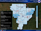
Looks like dry air further north and east really kills off the precipitation field as it moves further east. Hrrr has been consistent so far in showing the heavier snow accumulation in the west and then south of I-40.
However, I wouldn’t give up hope just yet. A last second northward trend with the precipitation field would be a game-changer and I would watch model trends later today. Whoever gets under the heaviest band tomorrow will likely get hammered.View attachment 123813
Same thing happened Friday Night. Granted that had a lot less moisture but it was good to the west then just fell apart and I never saw one flake. I dunno I mean hopefully we can get a window for snow at least but after all those runs with a nice band across the area yeah...
Topped out at 44.2 today after a low of 33.1. We had my daughters outdoor birthday party today and couldn’t book an indoor space. Had to go buy a fire pit to make it bearable for me and the old people. I’ve had the flu for the past 5 days.Agreed. I was forecast 29F, but only hit 32F. I'm still hovering at 42.8F.
L
Logan Is An Idiot 02
Guest
So 12z GFS still has the snow event for next week. Has everyone decided to ignore it?
Sent from my LM-Q730 using Tapatalk
No it did not.
Sent from my iPhone using Tapatalk
SimeonNC
Member
Nevermind. I misread the date on the other thread.No it did not.
Sent from my iPhone using Tapatalk
Sent from my LM-Q730 using Tapatalk
- Joined
- Jan 5, 2017
- Messages
- 3,775
- Reaction score
- 5,985
45 degrees and light winds. Wen blowtorch?
We may hit freezing by morning.
We may hit freezing by morning.
- Joined
- Jan 5, 2017
- Messages
- 3,775
- Reaction score
- 5,985
This is a below average January day for me. It's not frigid but fairly cool, even under full sun. I'm still looking for a warm up and ridging in early December. Refreshing!Forecasts for boone , Nashville and places west of here would be cold even for my middle of January. Here it looks like January , maybe January will bring us pleasant temps this year ? I’d like that!
L
Logan Is An Idiot 02
Guest
Just in time for winter.

Sent from my iPhone using Tapatalk

Sent from my iPhone using Tapatalk
Topped out at 44.2 today after a low of 33.1. We had my daughters outdoor birthday party today and couldn’t book an indoor space. Had to go buy a fire pit to make it bearable for me and the old people. I’ve had the flu for the past 5 days.
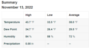
Pretty cold day by November standards, pretty windy too. There was a steep drop off with this airmass with temps and elevation.
This station is at 3000' on top of Burnt Mountain, very top of metro Atlanta.
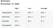
I took this shot at my lake today, some rime ice on Stover Mountain in the backround.

Last edited:
This follows the pattern that we seem to be in right now. 10-14 days below average followed by 10-14 days above.Just in time for winter.
Sent from my iPhone using Tapatalk
CHA only hit 41 for a high today. Tied with 2014 for 3rd coldest high for Nov 13th.
And just 65 miles to the north in Crossville it never got above 30.
And just 65 miles to the north in Crossville it never got above 30.
iGRXY
Member
Only got to 47 here. Was suppose to get around 52 today
Nice! Saw the smokies picked up an inch last night.View attachment 123818
Pretty cold day by November standards, pretty windy too. There was a steep drop off with this airmass with temps and elevation.
This station is at 3000' on top of Burnt Mountain, very top of metro Atlanta.
View attachment 123820
I took this shot at my lake today, some rime ice on Stover Mountain in the backround.
View attachment 123819
NBAcentel
Member
I get so tired of seeing this year after year.Just in time for winter.
Sent from my iPhone using Tapatalk
NBAcentel
Member
It’s weather tho. Gonna get BN maps like my map then your gonna get AN maps. It’s climo bro. Long duration cold in the southeast is hard anywaysI get so tired of seeing this year after year.
NBAcentel
Member
I really don’t see warm temps anytime soon, maybe a few warm days, week 3-4 imo might trend colder to AVG-Slightly BN. Even if we have a -PNA/-NAO, the Carolina’s is gonna deal with lot of wedging. Ridge position up around greenland is a kelvin benjamin becoming a tight end from a Popeyes biscuit away from being undercut/breaked by a cutoff and causing a decent duration -NAO around day 7-14. Only issue is, the MJO is entering a warmer phase, but looks to head to phase 7 in early December
Is it just me or does it seem like we’re following a pattern that you would see more so in neutral ENSO year? It’s interesting to follow because I’ve always read that the MJO has much less impact on North America when the ENSO is in a neutral phaseI really don’t see warm temps anytime soon, maybe a few warm days, week 3-4 imo might trend colder to AVG-Slightly BN. Even if we have a -PNA/-NAO, the Carolina’s is gonna deal with lot of wedging. Ridge position up around greenland is a kelvin benjamin becoming a tight end from a Popeyes biscuit away from being undercut/breaked by a cutoff and causing a decent duration -NAO around day 7-14. Only issue is, the MJO is entering a warmer phase, but looks to head to phase 7 in early December
BufordWX
Member
00z HRRR would be something. Almost no snow in OKC while places to the south get hammered. Unless this moves north overnight, I would be tempted to go south tomorrow. Might not be able to due to my schedule though.
Looking like a band of heavy wet snowfall with what could be 1-2” an hour rates. Couple that with some fall colors still on the trees it would be a sight to see!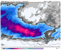
Looking like a band of heavy wet snowfall with what could be 1-2” an hour rates. Couple that with some fall colors still on the trees it would be a sight to see!

Step brothers unite!I get so tired of seeing this year after year.
High of 31 today
That actually looks a lot like a typical Niña cold footprint, like a lot of winter outlooks we’re showing in the fall! Just off of memory, with regards to temps using mostly climo, I would assumeVery rare to see a footprint like that View attachment 123821
Brent
Member
00z HRRR would be something. Almost no snow in OKC while places to the south get hammered. Unless this moves north overnight, I would be tempted to go south tomorrow. Might not be able to due to my schedule though.
Looking like a band of heavy wet snowfall with what could be 1-2” an hour rates. Couple that with some fall colors still on the trees it would be a sight to see!View attachment 123823
I thought I was done going south to chase when I moved to Tulsa but if that verifies... ? I'm definitely gonna be watching trends
Brent
Member
@@Brent! ?View attachment 123825
We'll see. I'm not expecting much. Another met doesn't even think it totally changes over here. A white ground would be a win I think given the trend last couple days
Last edited:
ForsythSnow
Moderator
I wonder where the actual temp bottom is here tonight. We've already blown past the 31 from the NWS tonight (sitting at 29.1) and still falling.
You know how it is though…if you’re in a low lying spot like @EmersonGA, the bottom can fall out. I’m already at 31.1F, but I would anticipate my regular rise that happens around midnight, then the settling back off right around 30-31F.I wonder where the actual temp bottom is here tonight. We've already blown past the 31 from the NWS tonight (sitting at 29.1) and still falling.
accu35
Member
I would keep an eye out on Friday/Saturday. Gefs starting to look interesting
WXinCanton
Member
28
25.3 here. The breeze never completely quit.You know how it is though…if you’re in a low lying spot like @EmersonGA, the bottom can fall out. I’m already at 31.1F, but I would anticipate my regular rise that happens around midnight, then the settling back off right around 30-31F.
- Status
- Not open for further replies.

