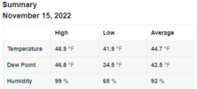
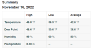
just over an inch of cold rain here. good napping weather lol
-
Hello, please take a minute to check out our awesome content, contributed by the wonderful members of our community. We hope you'll add your own thoughts and opinions by making a free account!
You are using an out of date browser. It may not display this or other websites correctly.
You should upgrade or use an alternative browser.
You should upgrade or use an alternative browser.
Pattern November 2022
- Thread starter RBR71
- Start date
- Status
- Not open for further replies.
Well one great thing about a day like this is the crock pot full of chili I’ve got going
I agree.. I'm about to make a big pot of potato soup.Well one great thing about a day like this is the crock pot full of chili I’ve got going
All our Chasers on the board ( weatherNC) this might be the best candidate all year. 3-6 feet on the way.


Drizzle Snizzle
Member
I've experienced about type of weather possible except for Lake Effect. It's on my bucket list.All our Chasers on the board ( weatherNC) this might be the best candidate all year. 3-6 feet on the way.

Weather today was pretty miserable. But nothing lasts forever, even cold November rain.
- Joined
- Jan 2, 2017
- Messages
- 1,566
- Reaction score
- 4,279
Flying out of Pitt today to Philly then GSP...rather windy up hereBumpy easing into ATL this morning. Cruising altitude headwind of 93MPH.
Brent
Member
Darklordsuperstorm
Member
forecast lows the next 6 nights here: 27, 25, 27, 24, 23, 28. ?
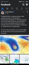
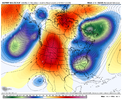
Definitely a severe signal for the Deep South and with that SE Canada vortex showing, you can bet that there will be some CAD in the CarolinasHappy Thanksgiving
View attachment 123896
Went below freezing at 8:30. Gonna be a cold one tonight!
Drizzle Snizzle
Member
your skies must have clearedWent below freezing at 8:30. Gonna be a cold one tonight!
They did around 5pm I think.your skies must have cleared
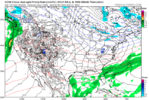
Turkey Day into next Black friday/Saturday has some crazy looking setups on models. A storm is coming and we will have CAD. The Euro gets really close for NC. GFS has some kind of triple point deal bouncing around everywhere. It has the HP way futher north mid week as the Euro slides it into the NE almost in prime spot before the moisture arrives. Lot will change, interesting to see how the confluence in the NE sets up mid week
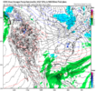
Heres the Euro surface last night and how it evolved post Turkey day.

WORLD FAMOUS CANADIAN

Heres the Euro surface last night and how it evolved post Turkey day.

WORLD FAMOUS CANADIAN

Mega frost this morning. So many great November mornings this year.
Yeah Thanksgiving not looking too warm around these parts now, looking seasonable to a touch below. In fact, next 10 days have mostly BN temps, with a day or two right around normal, nice stretch of weather with a little storm system for good measure. AND in about 2-3 weeks we will start looking out there for a possibility of that evasive white Christmas!Turkey Day into next Black friday/Saturday has some crazy looking setups on models. A storm is coming and we will have CAD. The Euro gets really close for NC. GFS has some kind of triple point deal bouncing around everywhere. It has the HP way futher north mid week as the Euro slides it into the NE almost in prime spot before the moisture arrives. Lot will change, interesting to see how the confluence in the NE sets up mid week
Heres the Euro surface last night and how it evolved post Turkey day.

WORLD FAMOUS CANADIAN

JHS
Member
I would like a repeat of late November and all of December 2015. Cold and dry is useless.
smast16
Member
Right where i want it 200 hrs out.
Euro troll starting early this year
Blue_Ridge_Escarpment
Member
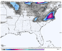
12Z GFS starting to get icy in WNC next Friday morning.
LukeBarrette
im north of 90% of people on here so yeah
Meteorology Student
Member
2024 Supporter
2017-2023 Supporter

The wedge has trended much stronger last couple runs....starting to think that people on this board might be more in play than they think.
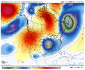
If we strengthen the southern energy like the Euro Control, things could get interesting. The strong 50/50 low looks favorable, especially if it keeps inching closer to the US.
The wedge has trended much stronger last couple runs....starting to think that people on this board might be more in play than they think.
LukeBarrette
im north of 90% of people on here so yeah
Meteorology Student
Member
2024 Supporter
2017-2023 Supporter
Might be soon time for our first storm thread....
Not far from making this a very impactful mixed precip threat for the board.
Not far from making this a very impactful mixed precip threat for the board.
We'll see how things trend. At the moment, most models and ensembles say this is a non-event.Might be soon time for our first storm thread....
Not far from making this a very impactful mixed precip threat for the board.
WEATHERBOYROY
Member
The trolling has started early and in earnest this year lol


L
Logan Is An Idiot 02
Guest
The trolling has started early and in earnest this year lol

Happy December!
Sent from my iPhone using Tapatalk
whatalife
Moderator
The trolling has started early and in earnest this year lol


I see my town. I can always tell where it’s at by all of the white.You are welcome. It'll be gone next run. LOL
The Euro control is absolutely the very best model for long range snowstorms, now that the DGEX is gone.Euro troll starting early this year
Last edited:
Euro showing a nice storm for Thanksgiving weekend. GFS has been showing this off and on for a while now, too. I think it might have legs.
- Status
- Not open for further replies.

