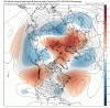
Case in point. Let's look at the 6z GEFS. The 12z isn't out yet on TT, but if we look at the 384 snapshot of the image Kylo posted above (the H5 anomaly plot), we can see what looks like an awesome west-based -NAO block in an ideal spot (circled in red). We also see a split flow pattern out in the Pacific and our old friend, the SW trough. We see an area of lower heights in the SW and off the NE coast, with normal heights over most of the central and eastern US.
View attachment 25930
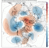
But now let's look at the actual H5 height map and see what the structure of the NAO and the overall pattern looks like. You can see the PV way up to the NW of the image, leaving stale cold over most of Canada. In fact, as we will see in a moment, it's actually a little warmer than normal there. Split flow brings in cool air, and the likelihood of storminess across the south will probably contribute to normal temps in that area.
But look in eastern Canada and Greenland. While the heights on the anomaly map are above normal, we see no pattern here that is supportive of buckling the flow (as we want to see with a -NAO), forcing colder temps south. Higher heights in that region may technically allow the calculated value to show up as a -NAO, but the resulting pattern does little to help us in any way, other than maybe to help keep the SE ridge from popping and making us warm:
View attachment 25931
And lastly, the resulting temp anomaly map speaks for itself:
View attachment 25932
Looks like normal to above normal temps, which, while certainly better than a torch, is nothing to be overly excited about. The main take-aways that I have that may be worth some excitement down the line is the fact that we are seeing a good southern storm track emerge. There is no talk of any drought. Also, we're seeing more promising signs in the Arctic regions than we did last year. Add in the fact that the models have false-started the torch pattern a couple of times, and I think there's enough reason to deposit some excitement and optimism in the bank so that it can be withdrawn later, when the situation better warrants it.

")