WxBlue
Meteorologist
Welcome
Sent from my iPhone using Tapatalk
Thanks! Lemme know if you need me to verify myself as a meteorologist
")
Welcome
Sent from my iPhone using Tapatalk
No pattern is permanent or even close. Nothing really gets "locked in" as the atmosphere is very fluid and is a fluid. Any extreme pattern will almost always revert closer to the mean at some point afterward before possibly reloading. In the meantime, what's not to like about our nearterm wx here in Nov with the prospects of one of the coldest first 3 weeks of Nov on record and even a decent shot at wintry precip in TN/NC. My advice is to enjoy it and not worry about winter. Your worrying isn't going to change what happens in winter, regardless. Enjoy what you already are getting as it is a rarity. This message is really for all of the worriers about winter.
'folks, the bathtub has, sloshed...' JBGreat point ... not to beat a dead horse, but think about the extreme heat in October and how rare that stretch was and now looking at what may be coming next week. Wow, in just what ... 5 weeks? Talk about the rubber band breaking. We (me included) just need to enjoy the extreme of what are seeing. Yes, I want snow as well ... but this is amazing cold for this time of year!
I don't think there will be a widespread 1-2" for the area's that do receive any snowfall. It's possible that the boarders of eastern TN/western NC may receive 1-2" but that's stretching it imo. I'm still going with more sleet/ice than snowfall, however, this is going to depend on how quick the deeper cold air will progress south and east. West of the mountains have a higher chance at frozen precipitation due to the colder air progressing south and east on time while the moisture would be in place. The cold will be having a hard time making it over the mountains on time for a greater chance of frozen precip east of the mountains, but we'll see about that. Central NC and points northeast up towards VA have a good chance at getting a quick dumping of snow just before the moisture moves out.Gotta love junky anafrontal setups to get the show rolling for season. Surface temperatures are obviously warm so we'll need a nice thump for anything to stick on the ground. There's some negative omega in the DGZ so maybe the snow rate will get it done for a quick inch or two in this particular set-up?
Actually it will be Mid November next week so thats a little better than Early November.If this wasn’t early November I’d be far more interested
Sent from my iPhone using Tapatalk

Good point, micro climates are key in East Tn and Western NC. Places in the Chattanooga Metro have ALREADY seen snow showers. From the Halloween Cold front. Up above 1500 ft.I don't think there will be a widespread 1-2" for the area's that do receive any snowfall. It's possible that the boarders of eastern TN/western NC may receive 1-2" but that's stretching it imo. I'm still going with more sleet/ice than snowfall, however, this is going to depend on how quick the deeper cold air will progress south and east. West of the mountains have a higher chance at frozen precipitation due to the colder air progressing south and east on time while the moisture would be in place. The cold will be having a hard time making it over the mountains on time for a greater chance of frozen precip east of the mountains, but we'll see about that. Central NC and points northeast up towards VA have a good chance at getting a quick dumping of snow just before the moisture moves out.


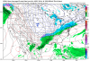
That's a delicious 1.9 inches for CHA though, airport elevation 682 ft above sea level.. Oh well, only 20+ more runs of the models to go.The Kuchera snowfall output is the most realistic output you're going to get. Eastern TN/Western NC highest mountain peaks, up to 5" including the mountains of southwest VA into WV. Steep lapse rates and convection/lift due to the mountains. The Kuchera is also showing that dumping of snow from Central NC to VA. Elsewhere that receives frozen precip in the southeast, little to no snow, more sleet/ice. View attachment 25557
Yes that's snow, but the freezing rain much further southThe Kuchera snowfall output is the most realistic output you're going to get. Eastern TN/Western NC highest mountain peaks, up to 5" including the mountains of southwest VA into WV. Steep lapse rates and convection/lift due to the mountains. The Kuchera is also showing that dumping of snow from Central NC to VA. Elsewhere that receives frozen precip in the southeast, little to no snow, more sleet/ice. View attachment 25557
This setup is extremely close to the snow even in December 2017. Does that jog your memory?I've seen this type of setup storm few years ago, cant remember which one it was and it wasn't November but the models showed the snow up towards Birmingham to Huntsville, but with a strong low in the gulf with dinamtic cooling, places south of i20 got crushed. To me this one looks more like a sleet fest

Yeah I see that, but I'm not worried it will change tomorrowdefinitely some difference between the euro last night to this nights run
Yeah that's it, thanksThis setup is extremely close to the snow even in December 2017. Does that jog your memory?
Sent from my iPhone using Tapatalk

only 7 days out. But yeah, probably a start back towards reality.Euro totals
Farther north because the Sw low attaches to the NS and the trough is very positive. Overall not too bad.
View attachment 25559


It will come out after the cold is gone. That's how southern stream waves work now.GFS changed pretty big at the surface so far back to suppression, but it’s no wonder, that Shortwave is slowing down again View attachment 25561

Nov 2012 , I thing had this exact thing happen even here! Had a small dusting on back of a frontal bandlooking at the gefs, starting to get little consistency, someone in the SE will probably see some token flakes, which is never a bad thing for November, when it comes to NC/north, I’ve seen many setups with a band of rain move thru, and the last portion of the rain band mixes with some snow at around 35-40 degrees, i can’t remember when that happened but it was somewhat recent View attachment 25562View attachment 25563
Nov 2012 , I thing had this exact thing happen even here! Had a small dusting on back of a frontal band
I deleted that post lol, because I don’t wanna get any hopes up at allthis system could still completely fail but at least it’s under hour 150


I can’t see my posts I think somethings wrong with tapatalk gif uploading
But I tried to post these thoughts:
Sorry for linking to my winter, but I have to head to work and I can’t retype and upload all the images here again.
Sent from my iPhone using Tapatalk
You have a winter account?
How many hours of daylight do you have left right now up there?Just an interesting observation for mby from the 0z EPS, while it had fewer members with sn from yesterday's runs (19 compared to 21-22) it also had more members with 2" plus (4 compared to 0 yesterday). Hmmmm go big or go home
edit: to add to this, yesterday's 12z eps had only 3 with 1" amounts all other's less than an 1", the 0z actually had 9 with 1" or more
Just an interesting observation for mby from the 0z EPS, while it had fewer members with sn from yesterday's runs (19 compared to 21-22) it also had more members with 2" plus (4 compared to 0 yesterday). Hmmmm go big or go home
edit: to add to this, yesterday's 12z eps had only 3 with 1" amounts all other's less than an 1", the 0z actually had 9 with 1" or more
Wrong threadHow many hours of daylight do you have left right now up there?
Sent from my SM-G975U using Tapatalk

 this system could still completely fail but at least it’s under hour 150