GoDuke
Member
Looks like hrrr failed on tonight’s line of storms. Huge bow echo headed my way.HRRR kind of respectable with the line in NC tomorrow....
Looks like hrrr failed on tonight’s line of storms. Huge bow echo headed my way.HRRR kind of respectable with the line in NC tomorrow....
Its cools outside in B'ham. Will there be enough energy to stoke a second round of severe storms ?Probably but will be a mess when it arrives. Some severe TS but the main concern should be road flooding for the morning drive.
Looks like round 2 has already started so yea for your area it looks better as in a better chance to see severe weather. I wouldn’t be shocked to see the temps raise a few degrees as the front moves in with such a strong south wind.Its cools outside in B'ham. Will there be enough energy to stoke a second round of severe storms ?
Probably so. Nothing extreme, but cape values will probably reach 600-1000 BHM and southward. Of course the farther south you go the better chance. The Euro was decently strong with low level shear, so I wouldn’t be surprised if we essentially see a redo of this afternoon with less instability/stronger shear. I’m guessing messy supercells at the onset before congealing into a line very late as the 500mb winds parallel the front.Its cools outside in B'ham. Will there be enough energy to stoke a second round of severe storms ?

Very impressive supercells over MS right now.

It definitely doesn't have that muggy feel like it had earlier today.Its cools outside in B'ham. Will there be enough energy to stoke a second round of severe storms ?


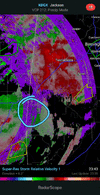
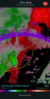
From Mobile nexradThat needs a warning in my eyes. Pretty strong rotation. I know it's at a high elevation from radar but a SVR Strm Warn would be minimal
according to nws chat that warn was cancelled and the birmingham office is now watching itFrom Mobile nexrad
Athens airport is reporting about 4.65 inches so far for both days. One of the weather underground stations in Athens has near 6. Been a while since there has been a flash flood warning. Looks like widespread 3 to 5 inched area wide and Definitely over produced vs model projections.Yea it’s gotta be 4-5 inches of rain here as well


Thankfully that couplet decreased in intensity as it moved along the south side of CAE once the couplet to its SE became the dominant circulation and moved across Calhoun County.had a friend send me a message and tell me they were sheltering in place in one of the state buildings in downtown cola.

75/72 on Jan 4th
77/72 now, cape numbers are pretty ridiculous for Jan.....
75/72 on Jan 4th