NWMSGuy
Member
Been busy myself today. Haven't had chance to really check things. This Wednesday/Thursday thing is intriguing.Sorry for lack of analysis or posts lol . Busy day will post shortly a, a formidable severe threat is shaping up for the missippi Alabama region Wednesday into Thursday on top of the Monday threat. Saturdays threat is still in question. I guess you could call it a conditional threat lol
Been waiting for your updates haha . And hoping Atlanta is in the mix for at least one of them!Sorry for lack of analysis or posts lol . Busy day will post shortly a, a formidable severe threat is shaping up for the missippi Alabama region Wednesday into Thursday on top of the Monday threat. Saturdays threat is still in question. I guess you could call it a conditional threat lol
Probably be Tuesday through Thursday time frame if Atlanta would have any bad weather. Of course it'll still rain a ton lolBeen waiting for your updates haha . And hoping Atlanta is in the mix for at least one of them!

SWly flow at 500mb. Good look for a QLCS right there especially with those sort of wind parametersThis is a sounding from far west Tennessee into East Arkansas for the day 5 threat. View attachment 128932
I’m more educated on the weather than the average person but I never learned how to read these. Anyone willing to educate?This is a sounding from far west Tennessee into East Arkansas for the day 5 threat. View attachment 128932
I'd look up a sounding explanation video easy to understand with someone explaining than reading it over textI’m more educated on the weather than the average person but I never learned how to read these. Anyone willing to educate?
Some of your more important factors tend to be LCL, 3CAPE, SBCAPE, 3KM/1KM HELICITY, LAPSE RATES. and your hodo graph which is on the top right. You'd want something that looks like a sickle almost; for some robust storms. Lot of other factors but those are some of the things I look at when glancing through for possibility of tornado potential.I’m more educated on the weather than the average person but I never learned how to read these. Anyone willing to educate?
Generally it's hard pressed to find a event in the south that doesn't congeal into a line of sorts. Its almost a a ticking time clock of opportunity where it's semi isolated lol. But your right, would want it more westerly hardly ever get that in Alabama or Mississippi. Gotta have that 500mb low sitting over Arkansas close to memphis for that to happen.SWly flow at 500mb. Good look for a QLCS right there especially with those sort of wind parameters
I think it's around the same time ?@Zander98al Looks like GFS brings these storms through Memphis around 12 Midnight Tuesday? What is the EURO showing timewise for this area?
Take it all way to the east coast lolY'all can keep the crap down there, we don't want it!


.png")
For Saturday?Gulf convection....... careful. Most reliable modeling is showing this right now.
For Saturday?
Thought it'd be interesting to add but on SPC discussion they mentioned adding risk area for portions of the south on Saturdays threat. Just roll the dice and see what we get I guess ?It's always fun to watch he models try to resolve gulf convection and the resultant storm coverage to the north. You can see the impact of a gulf coast mcs when you look at the 3k vs the 12k 18z nams with the 12k having better coverage farther north. As a whole this is the classic cape chasing MCS setup on Friday into Saturday. Not entirely sure what it anything could get going Saturday afternoon/ evening on the back of the mcs. There will be a lot of subsidence and poor thermos there that may be about to be offset by better kinematics.
The system next week has the makings of a Arklatex, miss, west TN, Missouri boot heel look with the best forcing racing north with a decaying mcs moving east across the region. There might be a secondary threat across parts of AL/GA as more energy rounds the base of the trough but I'm not sold

.gif")
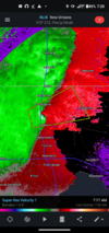
Here we go. It's on!There ya go. Thought this would be introduced soon. View attachment 128961
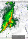
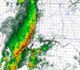
Any chance south Alabama could get rocked?Very sus storm in south sippi. Would expect to see a tornado warning with something like this
Maybe a couple severe storms tommorow afternoon. Not really sure with the Tuesday Wednesday threat. I'd imagine dynamics are going to be pretty far north. A couple days closer and we will probably know somethingAny chance south Alabama could get rocked?
Soooo. Can Atlanta get in on the fun?Maybe a couple severe storms tommorow afternoon. Not really sure with the Tuesday Wednesday threat. I'd imagine dynamics are going to be pretty far north. A couple days closer and we will probably know something
Maybe on day 5. I'f you cross your fingers haha.Soooo. Can Atlanta get in on the fun?