Z
Zander98al
Guest
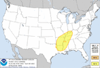
Day 6 for your neck of the woods, bigher potential than the Saturday Gulf Coast event. @tennessee storm 


The text shows a lot of uncertainty still remains lots of questions about northward progression of the warm front and thus instability. High ceiling, low floor. One to watch as we get closer
I actually think warm front progression will be a non issue, storm mode will be the question and magnitude. Likely looking at getting into the Ohio valley down to portions of the southeast.The text shows a lot of uncertainty still remains lots of questions about northward progression of the warm front and thus instability. High ceiling, low floor. One to watch as we get closer

Give me #15 or #16 you only live once ??
It’s gonna rain.@Arcc it's time to come out of retirement we need your analysis ??
If it’s messy that’s an automatic red flag for not having a tornado outbreak12z euro looks like a pretty bad tornado outbreak for a majority of the southeast, albeit a messy one lol
I guess, but most of the souths tornado days are messy. Mixed in with squall lines and line segments. With different storm modes everywhere lol. We don't have the typical plains tornado environment.If it’s messy that’s an automatic red flag for not having a tornado outbreak
Wonder if this is a case like several weeks ago where most of the crapvection developed further south and limited northward extent of the Severe.I guess, but most of the souths tornado days are messy. Mixed in with squall lines and line segments. With different storm modes everywhere lol. We don't have the typical plains tornado environment.
Not sure, not close enough to say I don't think so thoughWonder if this is a case like several weeks ago where most of the crapvection developed further south and limited northward extent of the Severe.
Are those EURO Flash Rate maps lighting up for this event?Not sure, not close enough to say I don't think so though
I don't know lol, I think thats a paid feature on the model websites I go with the free stuff. When it gets in the hi res models I think the free ones show it if I'm not mistaken.Do those EURO Flash Rate maps lighting up for this event?
Oh sorry, I guess I thought you may have had Weatherbell. Guess I may need to subscribe again lol.I don't know lol, I think thats a paid feature on the model websites I go with the free stuff. When it gets in the hi res models I think the free ones show it if I'm not mistaken.
Gulf complex eating up threat number 1 makes sense. Lol
NAM 3km and FV3 scenario might lead to somewhat of a threat for my area Saturday afternoon. Timing is the big issue ?. The other hi res models cant come soon enoughGulf complex eating up threat number 1 makes sense. Lol
You mean cips analogs?Anyone have the CWASP maps for Day 6?
Oh smh yes. Sorry, anything for those?You mean cips analogs?
