NBAcentel
Member
All I was saying was we are more likely to get a cut off to our west/SE ridge/vortex to the north versus the elongated trough on the eps. The eps smoothing this would likely lean the pattern too far right/progressiveI’m not even saying this off me liking warmth but most of the time the ridge wins in these sorts of patterns, cant say the same for CAD tho
More chair pics incoming...View attachment 77931View attachment 77932
Hope that’s exactly what happens , I want everyone Atlanta westwards to freeze their balls off while we bake . It’s what could have happened February had that stinking CAD not dumped on us! Then again it was the vortex causing CAD that slowed down the cold or something and prevented it from dumping in if I’m not mistaken .All I was saying was we are more likely to get a cut off to our west/SE ridge/vortex to the north versus the elongated trough on the eps. The eps smoothing this would likely lean the pattern too far right/progressive
Just out of curiosity, it looks like the MJO is heading towards phases 2-3 in the next 10 days....would that put the hold on any torch. I’m not sure what phases 2-3 mean for the 2nd half of March, but I seem to remember Webb showing some analogs the other day and they showed solidly below average.I’m not even saying this off me liking warmth but most of the time the ridge wins in these sorts of patterns, cant say the same for CAD tho
Yeah it’ll try, sometimes the SER can resist but it’ll be interesting to see what happens, I’m honestly concerned about severe wx as this is one of those patterns where we could easily trend to it on models around D8-10Just out of curiosity, it looks like the MJO is heading towards phases 2-3 in the next 10 days....would that put the hold on any torch. I’m not sure what phases 2-3 mean for the 2nd half of March, but I seem to remember Webb showing some analogs the other day and they showed solidly below average.
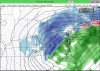
NAM shows some minor FGEN/WAA which is probably why it shows this, likely overdone since low levels are bone dry on the snow part tho


Them lucky Stards
NAM shows some minor FGEN/WAA which is probably why it shows this, likely overdone since low levels are bone dry on the snow part tho View attachment 77953View attachment 77954
Yeah wouldn’t shock me if there’s some flurries/sleet with that stuffFFC said they think its gonna be very limited to no precip at all because of how dry the boundary layer is. Good chance NAM is on crack. I will say though that if a band of mod-heavy precip does develop, good chance it can be snow looking at wetbulb profiles. This airmass is REALLY dry to the point of having fire hazard warnings earlier today.


That first shortwave trough looked disgusting for severe wx, not saying it’s right tho, but basing off ensembles, they show a favorable look for severe weather, wouldnt shock me if we get that then cooler weather

Rich get richer

In JanuaryMan this would be awesome, but it is merely a 330 hour Happy hour Goofy, which I'm not going to toss!!!
View attachment 77966
In January
Were definitely not done with cold, I said this a few days ago, but I have a feeling someone in the SE will see snow before March endsHot damn, maybe Bastardi is onto something after all for the last half of March! Could he be right this time?


I'm all for above normal November and March/April. Beautiful weather. Agree on below normal all other months.I'd take it anytime. Actually, if we could somehow have it that much BN in summer (near impossible), I'd love it then more than at any other time!


I'm kind of surprised there aren't more posts tbhAlmost ALL the short-long range Models have up-state, SC & NW Georgia getting winterly precip.. (36 hours),,
Almost ALL the short-long range Models have up-state, SC & NW Georgia getting winterly precip.. (36 hours),,
Brent buddy, I hope it’s right cause it clobbers middle Tennessee the next day.
oh we see it. I just choose to ignore falsehoods.I'm kind of surprised there aren't more posts tbh
It's like 12 hours out loloh we see it. I just choose to ignore falsehoods.
How do dewpoints compare to model runs though! Are they verifying lower ? Key question here . ?It's like 12 hours out lol
Virga storm. Might be the first time in months we had a solid all snow sounding lolHow do dewpoints compare to model runs though! Are they verifying lower ? Key question here . ?
side note - dews are low here , imagine if we had precip modernweenie


")