NBAcentel
Member
Yeah I don’t think it would work like How it would in winter, tbh probably would be issues with cutoffs in the Atlantic with that thoIs that a -NAO ? Bro , I don’t like to see positive heights centered in Greenland !
Yeah I don’t think it would work like How it would in winter, tbh probably would be issues with cutoffs in the Atlantic with that thoIs that a -NAO ? Bro , I don’t like to see positive heights centered in Greenland !

yeah maybe, from what I seen it out performs the euro, esp temp wiseLess cold bias and weenie runs perhaps ?

One map and your literally sucking on it tooSucks to suck lick View attachment 80023
Your enhanced risk wake county bust is a big suckOne map and your literally sucking on it too
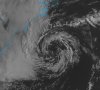
Are we sure that feature off the coast is completely cold core? It's got some decent thunderstorms in it.Sucks to suck lick View attachment 80023
Are we sure that feature off the coast is completely cold core? It's got some decent thunderstorms in it.
")
It has some decent thunderstorms with it and there actually seem to fairly close to the circulation center. This might be one of those that they determine to be a sub-tropical storm during post-analysisAre we sure that feature off the coast is completely cold core? It's got some decent thunderstorms in it.
Less cold bias and weenie runs perhaps ? @GaWx mentioned it is not too bad with that !
:Wow I thought I’ve seen a difference in how less progressive it was vs the old GFS, I was wrong lolFrom Fri from Maxar, @SD ‘s favorite company
“GFS OP Upgrade Early Next Week
Today’s Headlines:
After a delay due to severe weather earlier in the week, the GFS OP is scheduled for an upgrade with its 12z run on Monday. This will be the model’s first upgrade since changing to its FV3 dynamical core back in summer 2019. The new model increases the number of vertical layers from 64 to 127, extending to the upper
stratosphere. More details on the changes to data assimilation and physics can be found in NOAA’s Service Change Notice. In winter 2019-2020, the new model performed better than its predecessor at longer lead times, lessening a general cold bias. Some of the improvements were in areas of snow cover, where the new model does not overstate the cooling influence as much as in the previous version. The model also handles cold air damming setups better than in the previous version, but it is still too warm in association. A case study for the Arctic outbreak from February 2021 showed the model was worse than its predecessor at 5-10+ days lead. The new model poorly handled upper level shortwaves, which pushed the cold too far east and not far enough south when compared to observation. This was an outlier response relative to other, less extreme, retrospective case studies. In summers 2019 and 2020, the new model carried similar error (RMSE) as its predecessor in the Western Half. Some changes in how the model handles soil moisture lent a warm and dry bias here, which may be an issue for the upcoming summer in the West and Plains where drought is ex- pected to persist or intensify. Model skill is poorer in the Eastern Half, where both summers saw the model being too cool at most lead times. In extreme heat situations, the model carried similar skill as its predecessor. In terms of severe thunderstorms, the new model detects threats at longer leads when compared to the current version, which is in part related to the model’s better handling of boundary positions including dry lines. The new model is worse for instability measures, with a low bias for CAPE (convective available potential energy). In the tropics, the new model is better at identifying development threats at longer leads but also has a higher ‘false alarm rate.’ Improvements are for projected intensity (i.e. reduced weak bias); although, this improvement is for storms that develop and an issue for ‘false alarm’ storms. The upgraded model better handles rainfall for storms making landfall. As its predecessor, the model retains a right track bias in relation to being too progressive with upper lows and shortwaves. For more info: www.emc.ncep.noaa.gov/users/meg/gfsv16/.”
——————————————
Highlights from GaWx’s perspective:
1. Less cold bias in winter due partially to less overstating of cooling due to snow-cover.
2. OTOH, cold bias in summer E US
3. Increased TC false alarms though misses fewer genesis. Better with rainfall. Still has right bias.
4. @Myfrotho704_ type stuff he and others would find interesting about severe thunderstorms like being able to better pick up on outbreaks but low bias on CAPE.
Thanks for this, great read. Interesting it says it handled CAD better but still too warmFrom Fri from Maxar, @SD ‘s favorite company
“GFS OP Upgrade Early Next Week
Today’s Headlines:
After a delay due to severe weather earlier in the week, the GFS OP is scheduled for an upgrade with its 12z run on Monday. This will be the model’s first upgrade since changing to its FV3 dynamical core back in summer 2019. The new model increases the number of vertical layers from 64 to 127, extending to the upper
stratosphere. More details on the changes to data assimilation and physics can be found in NOAA’s Service Change Notice. In winter 2019-2020, the new model performed better than its predecessor at longer lead times, lessening a general cold bias. Some of the improvements were in areas of snow cover, where the new model does not overstate the cooling influence as much as in the previous version. The model also handles cold air damming setups better than in the previous version, but it is still too warm in association. A case study for the Arctic outbreak from February 2021 showed the model was worse than its predecessor at 5-10+ days lead. The new model poorly handled upper level shortwaves, which pushed the cold too far east and not far enough south when compared to observation. This was an outlier response relative to other, less extreme, retrospective case studies. In summers 2019 and 2020, the new model carried similar error (RMSE) as its predecessor in the Western Half. Some changes in how the model handles soil moisture lent a warm and dry bias here, which may be an issue for the upcoming summer in the West and Plains where drought is ex- pected to persist or intensify. Model skill is poorer in the Eastern Half, where both summers saw the model being too cool at most lead times. In extreme heat situations, the model carried similar skill as its predecessor. In terms of severe thunderstorms, the new model detects threats at longer leads when compared to the current version, which is in part related to the model’s better handling of boundary positions including dry lines. The new model is worse for instability measures, with a low bias for CAPE (convective available potential energy). In the tropics, the new model is better at identifying development threats at longer leads but also has a higher ‘false alarm rate.’ Improvements are for projected intensity (i.e. reduced weak bias); although, this improvement is for storms that develop and an issue for ‘false alarm’ storms. The upgraded model better handles rainfall for storms making landfall. As its predecessor, the model retains a right track bias in relation to being too progressive with upper lows and shortwaves. For more info: www.emc.ncep.noaa.gov/users/meg/gfsv16/.”
——————————————
Highlights from GaWx’s perspective:
1. Less cold bias in winter due partially to less overstating of cooling due to snow-cover.
2. OTOH, cold bias in summer E US
3. Increased TC false alarms though misses fewer geneses. Better with rainfall. Still has right bias.
4. @Myfrotho704_ type stuff he and others would find interesting about severe thunderstorms like being able to better pick up on outbreaks but low bias on CAPE.
Are we sure that feature off the coast is completely cold core? It's got some decent thunderstorms in it.

Looks mostly cold core for now, usually takes several days for tropical transition to occur and for a substantial warm core to build up. Some models show it becoming shallow warm core in the next day or twoNice view.. cool Feature off the NC/SC Coast this Morning..
Is it "warm core"?? It appears to be right over the Gulf Stream..
Snow it ? My goodness modernweenieLooks mostly cold core for now, usually takes several days for tropical transition to occur and for a substantial warm core to build up. Some models snow it becoming shallow warm core in the next day or two
Definitely not warm core, although yesterday it began to attempt to transition to subtropical. By today its a bare vortex with no convection and cold air entrained back into the core. SSTs are also simply too cold, maybe around 20 degrees Celsius.Nice view.. cool Feature off the NC/SC Coast this Morning..
Is it "warm core"?? It appears to be right over the Gulf Stream..

This looks like the old gfs from 6z yesterday. New GFS is much more enthusiastic about this becoming shallow warm coreDefinitely not warm core, although yesterday it began to attempt to transition to subtropical. By today its a bare vortex with no convection and cold air entrained back into the core. SSTs are also simply too cold, maybe around 20 degrees Celsius.View attachment 80043
It is from yesterday. I was showing how yesterday it was on the verge of transitioning. I didn't think conditions were expected to get better though and assumed it was all downhill from there.This looks like the old gfs from 6z yesterday. New GFS is much more enthusiastic about this becoming shallow warm core
Hour 384! My goodness has it gotten that bad ?Heading into mid April like ??View attachment 80044


I’m actually saying that the gfs model was upgraded at 12z yesterday, I wouldn’t look at runs from the older version of the gfs.It is from yesterday. I was showing how yesterday it was on the verge of transitioning. I didn't think conditions were expected to get better though and assumed it was all downhill from there.


No. That precip is Convective I need storms, and they move in Sunday morning/afternoon, weenieHug the CMC
It seems we are at odds.No. That precip is Convective I need storms, and they move in Sunday morning/afternoon
It seems we are at odds.
Here's the "king" euro
click me for euro
(let me know if this works right, should send you to a loop of 18z saturday


 Let me admit that I was wrong. Looks our little cyclone off the coast did achieve a shallow warm core, but will soon transition back to cold core.
That'd be perfect. I get my race on Saturday, we both get our storms on Sunday. (also did that link work right)