Wow! April is here, surely we're well on our way to summer now!
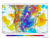
Just kidding, April fools, instead here's that west based -NAO you've wanted to see all winter long...
View attachment 37724
View attachment 37725
If there's a bright side to this crap, the temperature departures show more bark than bite when accounting for climo, and if anything, the models tend to have a cold bias that far out around this time of year.


.png")
