Probably a better chance up your way. These low clouds all day have pretty much solidified no chance today.14. I'm assuming the line out west will not survive the trip east
Sent from my SM-G950U using Tapatalk
Sent from my SM-G955U using Tapatalk
Probably a better chance up your way. These low clouds all day have pretty much solidified no chance today.14. I'm assuming the line out west will not survive the trip east
Sent from my SM-G950U using Tapatalk
Not a drop here today!Only light rain here. Luck of the draw. More irrigation this week. Looking forward to late Mon thru Wed for walking outside!
Only light rain here. Luck of the draw. More irrigation this week. Looking forward to late Mon thru Wed for walking outside!
")
That line died a slow miserable death to my west and now just some spotty light showers here and there..... looks like I will fall well short of .25 for the event. And to be honest I'm probably the only one not complaining about the lack of rain, with all the water issues I've dealt with lately I'll gladly take drought over too much rain any day.Probably a better chance up your way. These low clouds all day have pretty much solidified no chance today
Sent from my SM-G955U using Tapatalk
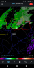
Rax being down is an issue this morning hard to see the rotation, this is out of WilmingtonTornado warning for Wake County! Radar indicated tornado near Zebulon.
Hook echo on RDU radar?Rax being down is an issue this morning hard to see the rotation, this is out of Wilmington


New cell to just to the west looks to impact downtown Raleigh in 20 minutes or so. I'll issue a report shortly.
That was intense rotation passed right by me! The sound was rather intense , the wind, everything !
Looks like that cell has rotation as well, we need video confirmation.... thanks. I kid of course, be safeNew cell to just to the west looks to impact downtown Raleigh in 20 minutes or so. I'll issue a report shortly.

That's look down right impressive
SPC playing catch up now, this certainly caught them off gaurd
Sent from my SM-G950U using Tapatalk
Yep, about to let loose here.That's look down right impressive