Webberweather53
Meteorologist
Omg!! What it shows for Columbia SC? It’s been dry
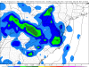
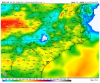
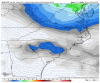
The 12z EPS in Columbia, SC basically looks like the 0z EPS did for Greensboro

Omg!! What it shows for Columbia SC? It’s been dry
Still time for rain accumulation to continue to increase here right @Webberweather53 ?The 12z EPS in Columbia, SC basically looks like the 0z EPS did for Greensboro
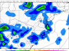
View attachment 41540
If your at the coast than I say your rain chances will increaseStill time for rain accumulation to continue to increase here right @Webberweather53 ?
Mmm. Perfect. Right where I wanna before the inevitable over correction...
")
Still time for rain accumulation to continue to increase here right @Webberweather53 ?
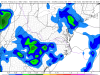
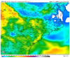
This also increases are severe chances each day and allows more warm sector which In turns causes more Convective precip, which In turns causes more rain, yikes

This isn't a precursor to an over correction, there's a very good reason the models suddenly shifted wetter here and the changes are likely real & still emerging as I've discussed in the new upper low thread.
It's definitely a far cry from those who thought the rain chances were basically disappearing next week.
Well it's been about 2 and 1/2 weeks since I had a multi-incher, I was beginning to think something was wrong. This will fit right in with the past 28 months!UK goes bonkers View attachment 41519
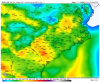
Often with a good NW flow we can get good MCS' coming through....we'll seeStarting to see hints of the SW US death ridge in the LR, that’s the real deal pattern for NW flow around the SE
If you like rain/storms, the rest of this month looks very promising.


Fear not! For the above normal temperatures will return just in time for December!GFS trended even colder for rest of May. Cold bias issues withstanding it looks like garbage. Memorial day looks chilly . March 1 kinda crap.
@GaWx if you get the chance could you post some of those maps that show the bias of the models ?
I'll need to check this on my PWS, but I seriously feel like i've seen more time in the 30's this May than I have in the 70's for MBY.GFS trended even colder for rest of May. Cold bias issues withstanding it looks like garbage. Memorial day looks chilly . March 1 kinda crap.
@GaWx if you get the chance could you post some of those maps that show the bias of the models ?
Thank you!!! I mean, we always have pretty hot summers and very high humidity. Couple years ago we had a fairly ok "coolish" summer and winter turned out great with 3 snow events for me. If we get a below average summer for at least half of it than bring itI don’t know about you guys but I’d be fine with a below average summer, We haven’t had one in a while.
Sounds good to me. I'll take a 2003 summer redo please, or even 2013!I don’t know about you guys but I’d be fine with a below average summer, We haven’t had one in a while.
2009 summer redo would be awesome. We had nights in the 50s in July and AugustSounds good to me. I'll take a 2003 summer redo please, or even 2013!
Perfect report ... perfect way to look at things ...I gotta admit the weather this evening is absolutely gorgeous. The temperature is pleasant and there is hardly a cloud in the sky. A perfect evening if I do say so.


Keep hearing that...been going on about 6 weeks now. Hot death ridges right around the corner, cold biases, and all that. But...at some point we will have to pay the piper. So eventually, the ridge will be real. Not looking forward to that day.Won’t be long before mr death ridge (wartime ridge ?) sets up and the ring of fire sets up and northern plains magic as reed timmer likes to call it becomes consistent, peep that 200mb anticyclonic flow near the Yucatán to which is favorable for TC development View attachment 41758View attachment 41759
This week into the weekend had decent potential to get fairly warm. Reminds me of winter where warm always finds a wayKeep hearing that...been going on about 6 weeks now. Hot death ridges right around the corner, cold biases, and all that. But...at some point we will have to pay the piper. So eventually, the ridge will be real. Not looking forward to that day.
Keep hearing that...been going on about 6 weeks now. Hot death ridges right around the corner, cold biases, and all that. But...at some point we will have to pay the piper. So eventually, the ridge will be real. Not looking forward to that day.
It will probably happen, but the cool has found a way so far this spring. It's been really nice.This week into the weekend had decent potential to get fairly warm. Reminds me of winter where warm always finds a way
