The nams have slowly shown more precip and the hrrr continues to pain snow flying across central NC on Tuesday
-
Hello, please take a minute to check out our awesome content, contributed by the wonderful members of our community. We hope you'll add your own thoughts and opinions by making a free account!
You are using an out of date browser. It may not display this or other websites correctly.
You should upgrade or use an alternative browser.
You should upgrade or use an alternative browser.
Wintry March 05-06th 2019 Wintry Weather
- Thread starter weather nerd
- Start date
Psalm 148:8
Member
- Joined
- Dec 25, 2016
- Messages
- 345
- Reaction score
- 792
I’m in pigeon forge this morning... bout to head home... NWS says 20%chance before 8 am.... 7:54 am... nothing.
Storm5
Member
I’ve got flurries currently
Sent from my iPhone using Tapatalk
Sent from my iPhone using Tapatalk
Snowflowxxl
Member
I think I might have seen some grapuel for like 3 minuets the morning. Never seen it before.
packfan98
Moderator
If it was like little styrofoam balls falling, then it was graupel.I think I might have seen some grapuel for like 3 minuets the morning. Never seen it before.
Never seen graupel. PLENTY of sleet though!If it was like little styrofoam balls falling, then it was graupel.
All in.......again.... lolEPS shifted the precip NWward, back to where the 0z suite was last night.
Arguably the most impressive EPS suite yet.
Reel it in @deltadog03
I definitely stand a chance of getting something down in Fayetteville Tue am
View attachment 17269
packfan98
Moderator
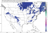
Nam looks interesting for some coastal areas:

NAM is moisting and the HRRR continues to paint a light snow across central NC ... maybe this becomes something fun... NOWCAST BABY
NBAcentel
Member
lol the 3km nam is slowly caving to the hrrr, the hrrr lol
Stuff around the piedmont is dealing with really dry dgzs but still

Stuff around the piedmont is dealing with really dry dgzs but still
Can I get a flurry pleaselol the 3km nam is slowly caving to the hrrr, the hrrr lol
Stuff around the piedmont is dealing with really dry dgzs but still
View attachment 17272
just one
NBAcentel
Member
Hrrr apears moist enough in the DGZ for some flurries tommorow 
Saw a few flurries in N AL. Its the best we can do this winter, so I will take it.
packfan98
Moderator
I know this is a novelty event, but it is allowing many folks to avoid the shutout for the winter. That is pretty important for some of us.
no you may not at least not before me lolCan I get a flurry please
just one


B
Brick Tamland
Guest
In the past we would have been golden most of the time with this setup. But this is the second time in a month that the system refused to trend NW far enough.
North, south, east, and west. It's been like this every winter for a long time now. Maybe a rogue snowflake will blow into the area.
Edit: And it is an exceptionally sad commentary in and of itself that we find ourselves wishing upon a star to see but a period of light flurry activity.
snowlover91
Member
Models have been juicing up this system on the 12z runs, the ICON is much wetter as is the RGEM. Areas in SE NC may see a nice little flurry event and maybe even a dusting if the rates are hard enough.
North, south, east, and west. It's been like this every winter for a long time now. Maybe a rogue snowflake will blow into the area.
Edit: And it is an exceptionally sad commentary in and of itself that we find ourselves wishing upon a star to see but a period of light flurry activity.
I usually don't care for mood snow in March but an hour or two of snow tomorrow morning would have been nice.
snowlover91
Member
North, south, east, and west. It's been like this every winter for a long time now. Maybe a rogue snowflake will blow into the area.
Edit: And it is an exceptionally sad commentary in and of itself that we find ourselves wishing upon a star to see but a period of light flurry activity.
Yeah but it'll be nice for the coastal areas to see some flakes fly if things work out... it's usually a bit harder for them to see snow and assuming models verify will be a nice treat for those folks.
The 12Z ICON, as just mentioned, is both the wettest overall and snowiest overall (central AL/GA, coastal NC) of any ICON run yet (Isn’t it warm biased? I think SC would also get some):
Attachments
snowlover91
Member
HRRR is showing snow breaking out at hour 15.

Yeah but it'll be nice for the coastal areas to see some flakes fly if things work out... it's usually a bit harder for them to see snow and assuming models verify will be a nice treat for those folks.
Bit harder? Coastal NC has been killing it, wouldn't be surprised if they have had more snow than Raleigh the past 10 years. Just a few recent ones.


Webberweather53
Meteorologist
I’m in the sweet spot here in Fayetteville
snowlover91
Member
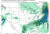
By hour 18 the HRRR shows a lot of precip breaking out across SC and NC.

oh look all rain in Columbia gosh I'm shocked.By hour 18 the HRRR shows a lot of precip breaking out across SC and NC.
View attachment 17285
snowlover91
Member
Bit harder? Coastal NC has been killing it, wouldn't be surprised if they have had more snow than Raleigh the past 10 years. Just a few recent ones.
Regardless of what they've seen in recent years the snowfall climo for Wilmington is 1.6" as seen here. Any snow along the coast is a welcome bonus, if they see some I will be happy for them.
snowlover91
Member
oh look all rain in Columbia gosh I'm shocked.
Yeah the HRRR is showing a large warm bubble in central SC. Not sure if it will verify or not but that's why the rain.

packfan98
Moderator
GFS coming in strong for SC...
snowlover91
Member
Pretty significant 4 run trend on the GFS.

? great!Yeah the HRRR is showing a large warm bubble in central SC. Not sure if it will verify or not but that's why the rain.
View attachment 17286

snowlover91
Member
I think based on current modeling the areas with the best chance to see some snow will be AL/GA and then up into parts of NC. SC it looks like a warm bubble may cause boundary layer issues which is a shame as qpf looks solid in SC.
I think based on current modeling the areas with the best chance to see some snow will be AL/GA and then up into parts of NC. SC it looks like a warm bubble may cause boundary layer issues which is a shame as qpf looks solid in SC.
The warm Atlantic strikes again! Anyway, here’s the clown map for entertainment only (not buying it right now but gives up to 1” not far from @GeorgiaGirl by the way):

One more north tic and I might see a rain dropPretty significant 4 run trend on the GFS.
View attachment 17287
B
Brick Tamland
Guest
By hour 18 the HRRR shows a lot of precip breaking out across SC and NC.
View attachment 17285
Looks good for Wake to the Triad. Surprised to see that.
snowlover91
Member
GFS snowfall map, maybe a dusting for a few lucky locations!
