GeorgiaGirl
Member
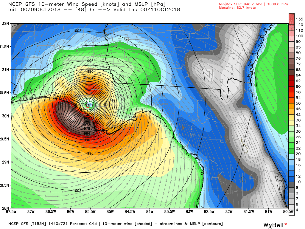
GFS seems a touch east, hasn't made the turn yet though. Also stronger which I hope is wrong.
In GA that 36 hours is the difference between a hurricane warning and a tropical storm warning by county....people hunkering down or not....they blow off the tropical storm. My family is from there. Obviously the cane doesn't care what county you live.
Actually same as 18z just little stronger at LFGFS seems a touch east, hasn't made the turn yet though. Also stronger which I hope is wrong.

It def. is stronger. ridge holding a bit longer as well so farTouch slower, much stronger, same track
Sent from my SM-G920V using Tapatalk
What's new right? Story of the summer right thereIt def. is stronger. ridge holding a bit longer as well so far
Looks lightly south....So 0z models have new data, only difference with the GFS is really strength and slight timing, Lord I hope goofus is being goofus

Shoot, maybe I was wrong, huge ring of near -90C tops ringing the eyewall.
Yes it is, oh the insanity..Maxing out the color scale now.
So 0z models have new data, only difference with the GFS is really strength and slight timing, Lord I hope goofus is being goofus

And slower, traveling parallel to the I-85 corridor thru AL/GA.CMC still west of most guidance. Stayed same as 12z
Yeah, NNW has been ongoing for a bit now. Gonna be interesting to see how far west he goes before the bendI'm noticing a NNW movement now as well and it appears he is picking up speed

Looks like he has ingested a little dry air, wishful thinking probably
Looks like he has ingested a little dry air, wishful thinking probably

Yep same, maybe 20 miles westLooks like GFS FV3 is going to look like last few runs .so far anyway
Well ATL would be on the NE quadrant not good for Central GA into ATLAnd slower, traveling parallel to the I-85 corridor thru AL/GA.

A tad slower, much stronger, same track...
Might be a little SE once well inland
Sent from my SM-G920V using Tapatalk
Major problem.