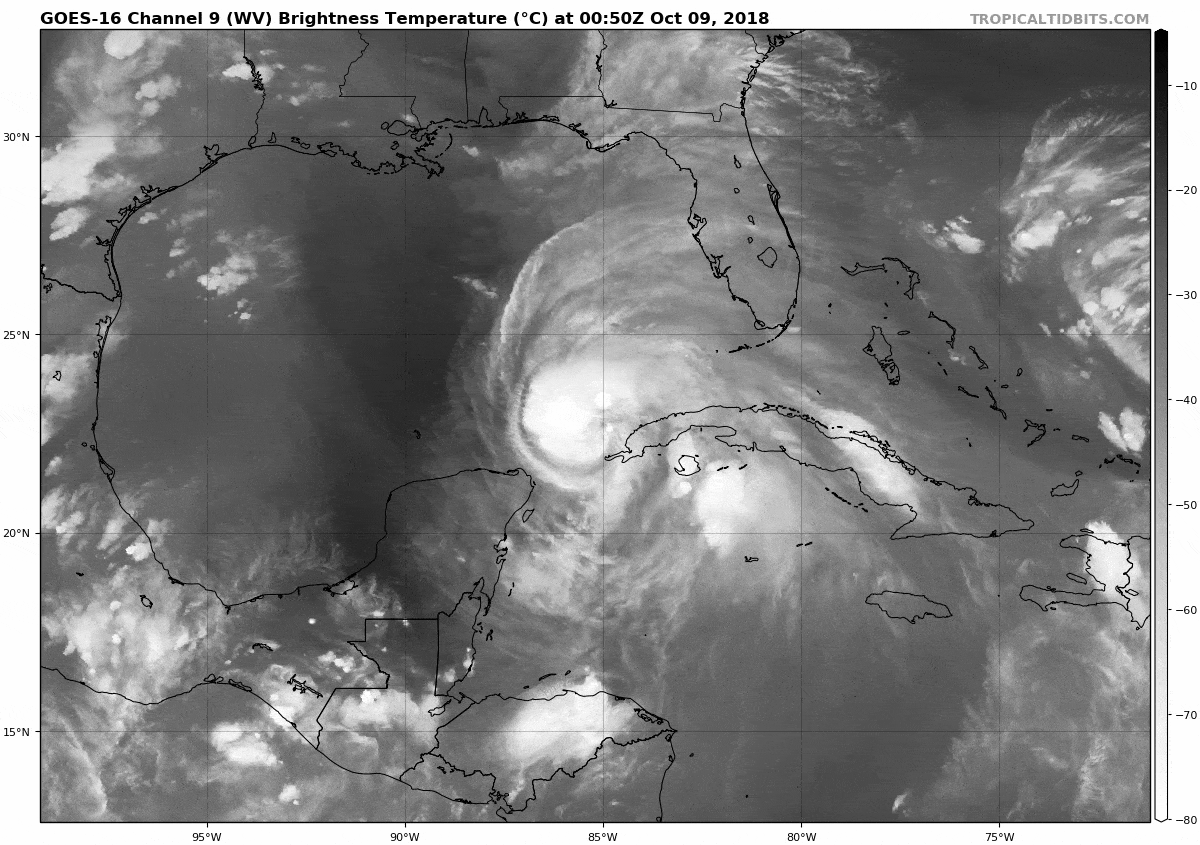
Looks like more new hot towers going up as we move toward DMIN
-
Hello, please take a minute to check out our awesome content, contributed by the wonderful members of our community. We hope you'll add your own thoughts and opinions by making a free account!
You are using an out of date browser. It may not display this or other websites correctly.
You should upgrade or use an alternative browser.
You should upgrade or use an alternative browser.
Tropical Major Hurricane Michael
- Thread starter ForsythSnow
- Start date
accu35
Member

Agreed .haven't seen that too much lately eitherYeah it’s like it brought the tropical atmosphere along with it. Typically dry air is what keeps hurricanes from making landfall as cat 4s and 5s.
Sent from my iPhone using Tapatalk
accu35
Member
Chris you gonna update your map?
Not tonight. In am yes .Chris you gonna update your map?
FV3 once inland definitely east of it's earlier runs but remember it was a west outlier to some degree.... almost exact track as GFS
accu35
Member
BHS1975
Member
With no dry air at landfall there will be intense convection bringing a lot more of the strong wind to the surface.
Sent from my iPhone using Tapatalk
Sent from my iPhone using Tapatalk
RollTide18
Member
NNW motion
Michael looks tiny so far
BHS1975
Member
FV3 once inland definitely east of it's earlier runs but remember it was a west outlier to some degree.... almost exact track as GFS
Yeap right over the crib this time.
Sent from my iPhone using Tapatalk
Wow HMON landfalls around 941mb
accu35
Member
Weather channel said it will grow in sizeMichael looks tiny so far
Wonder what time they’re planning on seeding this thing?
RollTide18
Member
Weather channel said it will grow in size
I don’t doubt it as it gets stronger, I just think back to Nate last year and how small of a storm that was.

looks a little further west again over inland?
Almost completely unaffected while traveling over land..? not so sure I buy that scenario
Ukmet shift futher south with inland tracks.
I'm really not sure, west, east, south, slower, faster, stronger.... it's 1:00 am what the heck am I doing? Lollooks a little further west again over inland?
DOWN TO 960.8mb
Ukie going to be way off, lowest pressure it shows is 967..... oops
RollTide18
Member
DOWN TO 960.8mb
And he has another day over water, yikes.
Snowflowxxl
Member
PCB -> MCN -> Columbia

Looks like the models are zeroing in on strength, 940-945mbs and 130-145mph. No real crazy RIC on any model, just steady strengthening until landfall.
accu35
Member
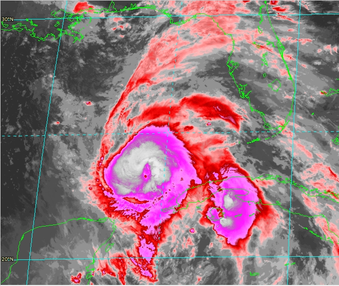
that dropped down 4mb in a matter of no time (highlighted in red)
Current Intensity Analysis
UW - CIMSS
ADVANCED DVORAK TECHNIQUE
ADT-Version 9.0
Tropical Cyclone Intensity Algorithm
----- Current Analysis -----
Date : 09 OCT 2018 Time : 044538 UTC
Lat : 23:29:31 N Lon : 85:23:51 W
CI# /Pressure/ Vmax
5.3 / 956.8mb/ 97.2kt
Current Intensity Analysis
UW - CIMSS
ADVANCED DVORAK TECHNIQUE
ADT-Version 9.0
Tropical Cyclone Intensity Algorithm
----- Current Analysis -----
Date : 09 OCT 2018 Time : 044538 UTC
Lat : 23:29:31 N Lon : 85:23:51 W
CI# /Pressure/ Vmax
5.3 / 956.8mb/ 97.2kt
Snowflowxxl
Member
I volunteer to stay up for the Euro
Brent
Member
recon pressure hasn't dropped yet, still around 970 mb so nothing crazy yet
Also eye was not closed on the VDM, not gonna see much strengthening atm with that
COMMA SHAPED EYE. LESS THEN 50% COVERAGE OPEN FROM S-W.
Also eye was not closed on the VDM, not gonna see much strengthening atm with that
COMMA SHAPED EYE. LESS THEN 50% COVERAGE OPEN FROM S-W.
Snowflowxxl
Member
Very NE at 24
Brent
Member
pressure actually up to 973 on the advisory
Brent
Member
.png")
accu35
Member
Not saying its wrong, but i don't see Michael making it that far east as Euro shows. Others models are much more west
Snowflowxxl
Member
Euro and gfs very similar
Brent
Member
thats pretty much the NHC track too