GeorgiaGirl
Member
Yeah, GFS looked about the same to me. Just one minor difference. Seems like we might be settling onto what's going to happen.
At 983 just south of ATL... that would be fun.Big FV3 run here, I’m riding with it until it changes.
At 983 just south of ATL... that would be fun.
At 60 it’s SW.FV3 looks a bit east. I’m starting to think Macon will be the sweet spot for GA
God I hope notFV3 looks a bit east. I’m starting to think Macon will be the sweet spot for GA
Actually, looks west a little at landfall. Maybe more east inland? Well after second look, just barely by a few miles east. But that's off the 12z data anywaysFV3 looks a bit east. I’m starting to think Macon will be the sweet spot for GA
") :weenie:
:weenie: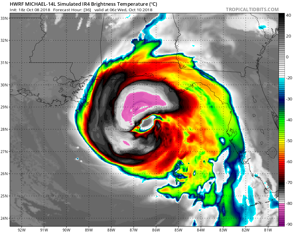
 Incoming t storm, pre-game for Michael
Wow, that would be problematic to say the least.
This would be crazy if it ever happened.
000
WTNT34 KNHC 082355
TCPAT4
BULLETIN
Hurricane Michael Intermediate Advisory Number 9A
NWS National Hurricane Center Miami FL AL142018
700 PM CDT Mon Oct 08 2018
...NOAA HURRICANE HUNTER AIRCRAFT FINDS MICHAEL A LITTLE STRONGER...
...STORM SURGE AND HURRICANE WARNINGS IN EFFECT FOR THE NORTHEASTERN
GULF COAST...
SUMMARY OF 700 PM CDT...0000 UTC...INFORMATION
----------------------------------------------
LOCATION...22.7N 85.2W
ABOUT 60 MI...100 KM NNW OF THE WESTERN TIP OF CUBA
ABOUT 485 MI...785 KM S OF APALACHICOLA FLORIDA
MAXIMUM SUSTAINED WINDS...85 MPH...140 KM/H
PRESENT MOVEMENT...N OR 355 DEGREES AT 12 MPH...19 KM/H
MINIMUM CENTRAL PRESSURE...970 MB...28.64 INCHES
WATCHES AND WARNINGS
--------------------
CHANGES WITH THIS ADVISORY:
None.
SUMMARY OF WATCHES AND WARNINGS IN EFFECT:
A Storm Surge Warning is in effect for...
* Okaloosa/Walton County Line Florida to Anclote River Florida
A Storm Surge Watch is in effect for...
* Anclote River Florida to Anna Maria Island Florida, including
Tampa Bay
* Alabama/Florida border to Okaloosa/Walton County Line Florida
A Hurricane Warning is in effect for...
* Alabama/Florida border to Suwannee River Florida
* The Cuban province of Pinar del Rio
A Hurricane Watch is in effect for...
* Alabama/Florida border to the Mississippi/Alabama border
A Tropical Storm Warning is in effect for...
* Alabama/Florida border to the Mississippi/Alabama border
* Suwanee River Florida to Chassahowitzka Florida
* The Cuban province of the Isle of Youth
* The coast of Mexico from Tulum to Cabo Catoche, including Cozumel
A Tropical Storm Watch is in effect for...
* Chassahowitzka to Anna Maria Island Florida, including Tampa Bay
* Mississippi/Alabama border to the Mouth of the Pearl River
A Storm Surge Warning means there is a danger of life-threatening
inundation, from rising water moving inland from the coastline,
during the next 36 hours in the indicated locations. For a depiction
of areas at risk, please see the National Weather Service Storm
Surge Watch/Warning Graphic, available at hurricanes.gov. This is a
life-threatening situation. Persons located within these areas
should take all necessary actions to protect life and property from
rising water and the potential for other dangerous conditions.
Promptly follow evacuation and other instructions from local
officials.
A Hurricane Warning means that hurricane conditions are expected
somewhere within the warning area. A warning is typically issued
36 hours before the anticipated first occurrence of tropical-storm-
force winds, conditions that make outside preparations difficult or
dangerous. Preparations to protect life and property should be
rushed to completion.
A Tropical Storm Warning means that tropical storm conditions are
expected somewhere within the warning area within 36 hours.
A Storm Surge Watch means there is a possibility of life-
threatening inundation, from rising water moving inland from the
coastline, in the indicated locations during the next 48 hours.
A Hurricane Watch means that hurricane conditions are possible
within the watch area. A watch is typically issued 48 hours
before the anticipated first occurrence of tropical-storm-force
winds, conditions that make outside preparations difficult or
dangerous.
A Tropical Storm Watch means that tropical storm conditions are
possible within the watch area, generally within 48 hours.
Interests elsewhere across the southeastern United States should
monitor the progress of Michael.
For storm information specific to your area in the United
States, including possible inland watches and warnings, please
monitor products issued by your local National Weather Service
forecast office. For storm information specific to your area outside
the United States, please monitor products issued by your national
meteorological service.
DISCUSSION AND OUTLOOK
----------------------
At 700 PM CDT (0000 UTC), the center of the eye of Hurricane Michael
was located by a NOAA Hurricane Hunter aircraft near latitude 22.7
North, longitude 85.2 West. Michael is moving toward the north near
12 mph (19 km/h). A northward to north-northwestward motion at a
slightly faster forward speed is expected through Tuesday night,
followed by a northeastward motion on Wednesday and Thursday. On
the forecast track, the center of Michael will move over the
southeastern Gulf of Mexico tonight, then move across the
eastern Gulf of Mexico Tuesday and Tuesday night. The center of
Michael is expected to move inland over the Florida Panhandle or
Florida Big Bend area on Wednesday, and then move northeastward
across the southeastern United States Wednesday night and Thursday.
Reports from the reconnaissance aircraft indicate that maximum
sustained winds have increased to near 85 mph (140 km/h) with higher
gusts. Steady to rapid strengthening is forecast during the next day
or so, and Michael is forecast to become a major hurricane by
Tuesday night.
Hurricane-force winds extend outward up to 35 miles (55 km) from
the center and tropical-storm-force winds extend outward up to 175
miles (280 km).
The minimum central pressure recently measured by the NOAA
Hurricane Hunter aircraft was 970 mb (28.64 inches).
HAZARDS AFFECTING LAND
----------------------
STORM SURGE: The combination of a dangerous storm surge and the
tide will cause normally dry areas near the coast to be flooded by
rising waters moving inland from the shoreline. The water has the
potential to reach the following heights above ground if peak surge
occurs at the time of high tide...
Indian Pass FL to Cedar Key FL...8-12 ft
Cedar Key FL to Crystal River FL...6-8 ft
Okaloosa/Walton County Line FL to Indian Pass FL...6-9 ft
Crystal River FL to Anclote River FL...4-6 ft
Anclote River to Anna Maria Island FL including Tampa Bay...2-4 ft
Alabama/Florida border to Okaloosa/Walton County Line FL...2-4 ft
WIND: Hurricane conditions will continue over portions of the far
western Cuban province of Pinar del Rio through this evening.
Tropical storm conditions are expected across the remainder of the
warning areas in Cuba and the Yucatan Peninsula through tonight.
Hurricane conditions are expected within the hurricane warning
area along the U.S. Gulf Coast by Wednesday, with tropical storm
conditions expected by Tuesday night or early Wednesday. Tropical
storm conditions are expected in the tropical storm warning area by
Tuesday night or early Wednesday, and are possible within the
tropical storm watch area by that time. Hurricane conditions
are possible within the hurricane watch area by Wednesday.
RAINFALL: Michael is expected to produce the following rainfall
amounts through Friday...
Western Cuba...4 to 8 inches, with isolated maximum amounts of 12
inches. This rainfall could lead to life-threatening flash floods
and mudslides.
Florida Panhandle and Big Bend across Georgia into South Carolina...
4 to 8 inches, with isolated maximum amounts of 12 inches. This
rainfall could lead to life threatening flash floods.
Florida Peninsula, Florida Keys, North Carolina, portions of the
Mid-Atlantic States, and the southern New England coast...2 to 4
inches with isolated maximum amounts of 6 inches. This rainfall
could lead to life-threatening flash floods.
Yucatan Peninsula...1 to 2 inches.
SURF: Swells generated by Michael are affecting the south coast of
Cuba and the east coast of the Yucatan Peninsula. Swells are
expected to begin affecting the coast of the eastern and northern
Gulf of Mexico during the next day or so. These swells are likely
to cause life-threatening surf and rip current conditions. Please
consult products from your local weather office.
NEXT ADVISORY
-------------
Next complete advisory at 1000 PM CDT.
$$
Forecaster Stewart

I didn't remember Charley, but I do now! 5 changes in path over 4 days, with end result not even close.If relative size as projected there at the end of this run was anything ... remember Charlie?
sounds familiar!Yep. Looked at one drop and there are 96 knot winds not too far off the surface. A slight drop and it'll blow up in wind speed fast.Looks like we might have take off? Again?
Looks like we might have take off? Again?

