How does the 12z UKMet look?
-
Hello, please take a minute to check out our awesome content, contributed by the wonderful members of our community. We hope you'll add your own thoughts and opinions by making a free account!
You are using an out of date browser. It may not display this or other websites correctly.
You should upgrade or use an alternative browser.
You should upgrade or use an alternative browser.
Tropical Major Hurricane Irma (Part 1)
- Thread starter Snowfan
- Start date
- Status
- Not open for further replies.
A couple of those solutions looks like it may be possible for Irma to move out to sea ?
Looked like it was a tick north (and I mean very slight) early but makes the turn just a little later, thus an overall w shiftDefinitely a W/SW shift vs 00z
Sent from my SM-J320VPP using Tapatalk
Only 4 miss land....
A couple of those solutions looks like it may be possible for Irma to move out to sea ?
We would know pretty quick. As I stated above, the ones with that chance move well north way before Florida and seperate themselves from the consensus.
Storm5
Member
00z
12z


Sent from my SM-J320VPP using Tapatalk
12z


Sent from my SM-J320VPP using Tapatalk
ForsythSnow
Moderator
NAVGEM = No. Please no.

accu35
Member
Charlie your spolling us with this live thread
Storm5
Member
Again the NW track after landfall is supported

Sent from my SM-J320VPP using Tapatalk

Sent from my SM-J320VPP using Tapatalk
Storm5
Member
Florida and SC the sweet spot on the 12z eps
Sent from my SM-J320VPP using Tapatalk
Sent from my SM-J320VPP using Tapatalk
Irma's future track looks like a lot of my golf shots today, long but turning right.....
pcbjr
Member
how in the hell can you say "sweet" in this context ... LOLFlorida and SC the sweet spot on the 12z eps
Sent from my SM-J320VPP using Tapatalk
Again the NW track after landfall is supported
Sent from my SM-J320VPP using Tapatalk
You know my hitting Cuba, weakening and hitting Tampa joke from a few days ago, really isn't that far fetched now.
Cliftown04
Member
Selfish question here but with that northwest turn after landfall would most of the precip still be on that eastern side? Good discussion folks! Can I rest assured this site can hold up to this heavy traffic?
Today Per 12z its looking more and more likely to have some major impacts from Irma to SC.. Landfall is also looking more likely!!
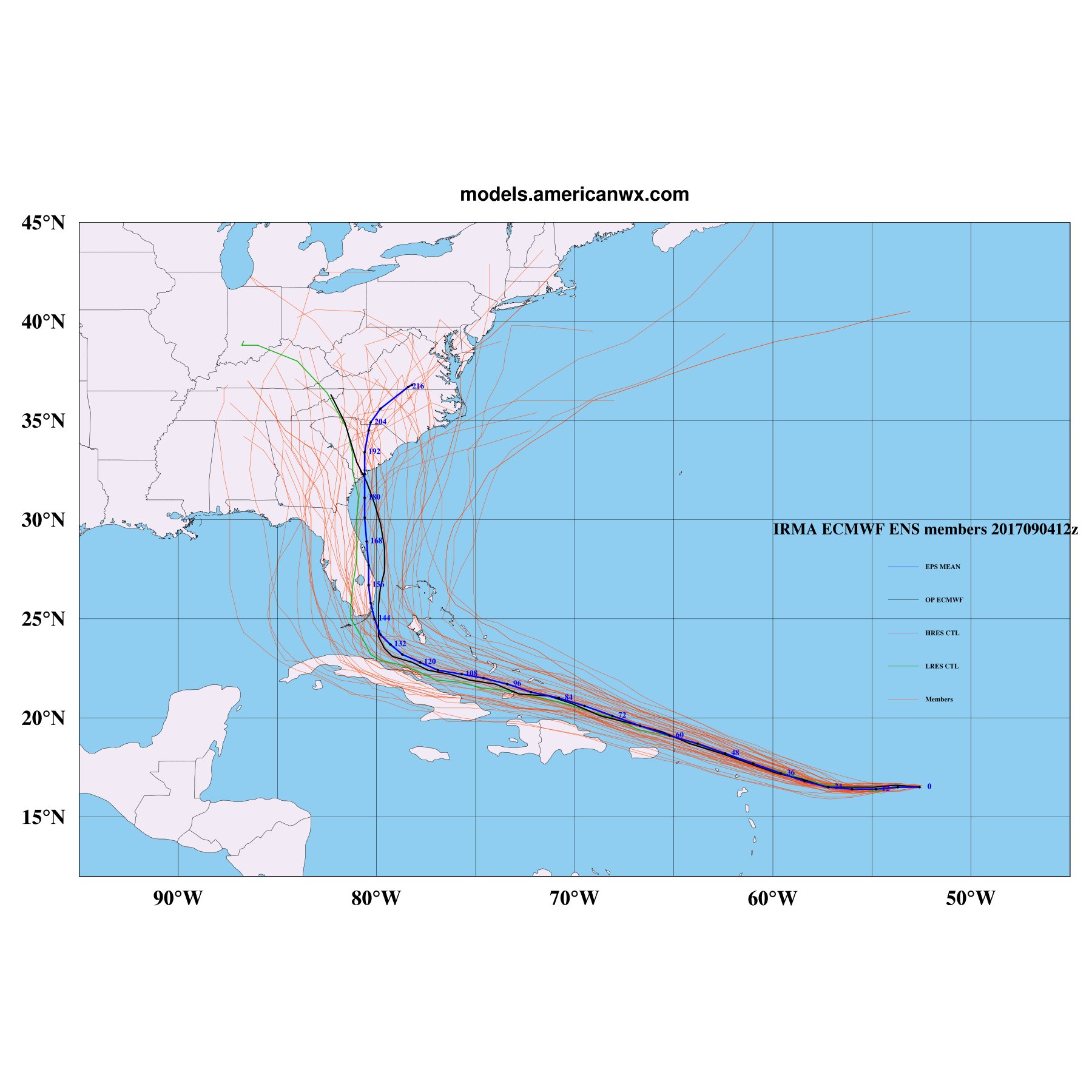
You know if you take away the far left and right outliers, the mean would be right where that green line runs.
Storm5
Member
You know if you take away the far left and right outliers, the mean would be right where that green line runs.
That graphic is great for showing the west shift in the eps
Sent from my SM-J320VPP using Tapatalk
Irma's future track looks like a lot of my golf shots today, long but turning right.....
Well to have to state the obvious, you can't play a sport while glued to your phone....
Can't get anything past you... Lol. Actually the Op run and the mean crisscross right over Hilton Head SC,You know if you take away the far left and right outliers, the mean would be right where that green line runs.
Lol I'm finished now, didn't look at my phone once.... thank you very muchWell to have to state the obvious, you can't play a sport while glued to your phone....
Obviously the west shift with the Eps is troubling because it was the one thing still showing ots solutions last night and now that's just about gone....That graphic is great for showing the west shift in the eps
Sent from my SM-J320VPP using Tapatalk
pcbjr
Member
Is that "!!" to express excitement, or excited expectations?Today Per 12z its looking more and more likely to have some major impacts from Irma to SC.. Landfall is also looking more likely!!
That graphic is great for showing the west shift in the eps
Sent from my SM-J320VPP using Tapatalk
It is. Is that what the green line is supposed to show?
I do think a lot of people want this to make landfall as a cat 5. Some people, for whatever reason, love to see destruction. Im not saying thats good or bad, its just the way some people are.Is that "!" to express excitement, or excited expectations?
pcbjr
Member
We have a hospital ward for folks that revel in other folks' hurt ...I do think a lot of people want this to make landfall as a cat 5. Some people, for whatever reason, love to see destruction. Im not saying thats good or bad, its just the way some people are.
I do think a lot of people want this to make landfall as a cat 5. Some people, for whatever reason, love to see destruction. Im not saying thats good or bad, its just the way some people are.
All I want is to see Jeff take flight, that is all. Is it too much to ask?
WeatherWatch
Member
I've been seeing some questions rather or not Irma will go OTS?
Irma has a better chance at effecting land/making landfall vs going OTS. Remember, don't focus on excact track.
Sent from my SM-J700T1 using Tapatalk
Irma has a better chance at effecting land/making landfall vs going OTS. Remember, don't focus on excact track.
Sent from my SM-J700T1 using Tapatalk
From Huffman showing the shift...It is. Is that what the green line is supposed to show?
B
Brick Tamland
Guest
So now it looks like it either hits FL and then SC or NC or both, or miss Florida and hit SC or NC or both. Seems like SC and NC lose either way.
Has any storm ever made 3 landfalls in the US ?
SimeonNC
Member
Would Tennessee or Kentucky be good evacuation places to go to?
Expectations. Really?? ExcitementIs that "!!" to express excitement, or excited expectations?
ForsythSnow
Moderator
Ivan made 3, but one was a hurricane, one a depression, and the other a TS.Has any storm ever made 3 landfalls in the US ?
Storm5
Member
It's the control member per AllanIt is. Is that what the green line is supposed to show?
Sent from my SM-J320VPP using Tapatalk
It's the control member per Allan
Sent from my SM-J320VPP using Tapatalk
Good to know. It's right where I think the mean aught to be.
Hey I created a thread because I think this would be great info but could clutter up this one.... so can you move these post there? I can't or don't know how LolThat is definitely a good option, but you have to run them outside. I don't have a generator, but I do have a very large battery that has power outlets on it, and can be hooked up to a solar panel that it came with. Probably a good investment for ice storms up here, but for coastal areas, a generator is best.
http://southernwx.com/community/threads/storm-preparation-just-in-case.234/
Yeah the blue was the mean, the black was the operational green as storm mentioned was the control....their pretty close actuallyGood to know. It's right where I think the mean aught to be.
Freeze bottled water to kill 2 birds with one stone. Fill your bathtubs with water, not for drinking but so you can flush the toilet. Charcoal to grill outside, non-perishable food, etc. basically plan for a long camping trip!
- Status
- Not open for further replies.