-
Hello, please take a minute to check out our awesome content, contributed by the wonderful members of our community. We hope you'll add your own thoughts and opinions by making a free account!
You are using an out of date browser. It may not display this or other websites correctly.
You should upgrade or use an alternative browser.
You should upgrade or use an alternative browser.
Tropical Major Hurricane Helene
- Thread starter SD
- Start date
- Status
- Not open for further replies.
Forevertothee
Member
With all the globals-GFS, Icon, GEM, and Euro showing a more east track and all nearby Athens, I am concerned that the Upstate of SC will have more issues than currently forecasted in regard to wind.0Z Euro: 978 mb at Athens, which is 75 miles E of NHC track/similar to UKMET/GFS/CMC and very close to all-time record low SLP at Athens
Gardenfool
Member
3.2 inches of rain in Decatur GA as of 0157 on 09/26/24
Very much so.With all the globals-GFS, Icon, GEM, and Euro showing a more east track and all nearby Athens, I am concerned that the Upstate of SC will have more issues than currently forecasted in regard to wind.
Looks like we’ve fallen about 2-3mb since the last recon mission. With the most recent pass
With all the globals-GFS, Icon, GEM, and Euro showing a more east track and all nearby Athens, I am concerned that the Upstate of SC will have more issues than currently forecasted in regard to wind.
Maybe I’m not recalling correctly, but I can’t recall a storm for which the NHC was notably west of the Euro, GFS, and UKMET for multiple runs.
Downeastnc
Member
Maybe I’m not recalling correctly, but I can’t recall a storm for which the NHC was notably west of the Euro, GFS, and UKMET for multiple runs.
No I can't at least...it's like they are giving no weight to the globals...they are really banking on the cane models having the interaction between Helene and the ULL nailed down...I would think setups like this have high bust potential.
Downeastnc
Member
Still cant seem to maintain hot towers they go up then come down....got to still be dealing with some dry air in the core. Still Helene is slowly getting stronger and if she can sort her issues she could still bomb out but it doesn't appear she will anytime in the next several hrs.
No I can't at least...it's like they are giving no weight to the globals...they are really banking on the cane models having the interaction between Helene and the ULL nailed down...I would think setups like this have high bust potential.
But even at 18Z, only the HMON was as far W as the NHC, especially over GA!
Still cant seem to maintain hot towers they go up then come down....got to still be dealing with some dry air in the core. Still Helene is slowly getting stronger and if she can sort her issues she could still bomb out but it doesn't appear she will anytime in the next several hrs.
Doesn’t her very large size make it difficult for RI? Because of this along with the dry air I’ve been thinking the H models going way down to 920 were probably way too strong. I’ve been thinking 940 is more reasonable and that’s still a very strong storm. I still think 940-5 is attainable.
Downeastnc
Member
Now just imagine the turn from NE to N happen 6 hrs sooner or later than the models show with a forward speed of 25 mph. The NHC is damn good but this is one of those bite em in the ass setups...But even at 18Z, only the HMON was as far W as the NHC, especially over GA!
Released 2:19AM EDT: 970 mb/slow drop
URNT12 KNHC 260619
VORTEX DATA MESSAGE AL092024
A. 26/05:48:10Z
B. 23.56 deg N 086.49 deg W
C. 700 mb 2843 m
D. 970 mb
E. 195 deg 4 kt
F. OPEN NW
G. C24
H. 60 kt
I. 315 deg 28 nm 05:39:30Z
J. 064 deg 54 kt
K. 315 deg 36 nm 05:37:00Z
L. 72 kt
M. 131 deg 53 nm 06:03:30Z
N. 230 deg 80 kt
O. 131 deg 47 nm 06:02:00Z
P. 9 C / 3064 m
Q. 14 C / 3046 m
R. 5 C / NA
S. 1234 / 07
T. 0.02 / 2 nm
U. AF309 1409A HELENE OB 04
MAX FL WIND 80 KT 131 / 47 NM 06:02:00Z
MAX FL TEMP 15 C 311 / 11 NM FROM FL CNTR
Downeastnc
Member
Doesn’t her very large size make it difficult for RI? Because of this along with the dry air I’ve been thinking the H models going way down to 920 were probably way too strong. I’ve been thinking 940 is more reasonable and that’s still a very strong storm. I still think 940-5 is attainable.
Sure takes big storms long time to wind up...but the IR loop tells the tale the big flare ups are not sustaining and forming a CDO...if they could then 940 would be the ceiling not the floor.
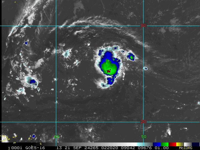
Currently on IR you can see that the coldest cloud tops are in that one area on the NW side...you want to see the entire core that color, that and the fact it has no apparent eye yet means she is still struggling with her inner core. You can see the dry air to her east spiral into the center.

Downeastnc
Member
Also the globals all pretty much had the pressure around 970 at 2am and 960-965 by 8am...all the cane models have her at 940-950 by 8am...right now based on her current look I would give the edge to the globals...
Belle Lechat
Member
- Joined
- Aug 29, 2021
- Messages
- 1,547
- Reaction score
- 1,224
An hour ago
054930 2332N 08624W 6970 02880 9691 +146 +057 200019 021 037 004 00
054930 2332N 08624W 6970 02880 9691 +146 +057 200019 021 037 004 00
Belle Lechat
Member
- Joined
- Aug 29, 2021
- Messages
- 1,547
- Reaction score
- 1,224
060700 2249N 08539W 6972 03017 9907 +092 +046 224069 070 086 003 00
Peak 10-second average surface wind speed occurring within the encoding interval from the Stepped Frequency Microwave Radiometer (SFMR), in kt.
99 mph

Peak 10-second average surface wind speed occurring within the encoding interval from the Stepped Frequency Microwave Radiometer (SFMR), in kt.
99 mph
Belle Lechat
Member
- Joined
- Aug 29, 2021
- Messages
- 1,547
- Reaction score
- 1,224

Belle Lechat
Member
- Joined
- Aug 29, 2021
- Messages
- 1,547
- Reaction score
- 1,224
Also the globals all pretty much had the pressure around 970 at 2am and 960-965 by 8am...all the cane models have her at 940-950 by 8am...right now based on her current look I would give the edge to the globals...
And yet even with the higher SLP of the globals, they all are flirting with all-time record low SLP in much of C and NE GA!
Belle Lechat
Member
- Joined
- Aug 29, 2021
- Messages
- 1,547
- Reaction score
- 1,224
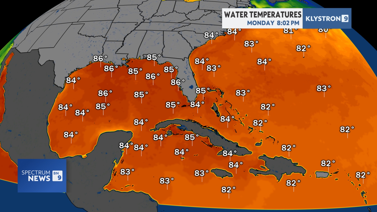

Tropical Cyclone Heat Potential
Belle Lechat
Member
- Joined
- Aug 29, 2021
- Messages
- 1,547
- Reaction score
- 1,224

Belle Lechat
Member
- Joined
- Aug 29, 2021
- Messages
- 1,547
- Reaction score
- 1,224

I'm afraid to say that this storm is going to catch a lot of people with their pants down.And yet even with the higher SLP of the globals, they all are flirting with all-time record low SLP in much of C and NE GA!
They're going to be surprised by how much this affects inland GA and the Carolinas with its fury.
I hope I'm wrong.
Belle Lechat
Member
- Joined
- Aug 29, 2021
- Messages
- 1,547
- Reaction score
- 1,224

Belle Lechat
Member
- Joined
- Aug 29, 2021
- Messages
- 1,547
- Reaction score
- 1,224

Belle Lechat
Member
- Joined
- Aug 29, 2021
- Messages
- 1,547
- Reaction score
- 1,224
156 AM EDT THU SEP 26 2024
THE NATIONAL WEATHER SERVICE IN MIAMI HAS ISSUED A
* TORNADO WARNING FOR...
NORTHWESTERN COLLIER COUNTY IN SOUTHWESTERN FLORIDA...
* UNTIL 230 AM EDT.
* AT 155 AM EDT, A SEVERE THUNDERSTORM CAPABLE OF PRODUCING A TORNADO
WAS LOCATED OVER GOLDEN GATE ESTATES, MOVING NORTH AT 35 MPH.
HAZARD...TORNADO.
SOURCE...RADAR INDICATED ROTATION.
* LOCATIONS IMPACTED INCLUDE...
GOLDEN GATE ESTATES, BIG CORKSCREW ISLAND, WEST TOLL GATE ON
ALLIGATOR ALLEY, ORANGETREE, AND CORKSCREW SWAMP SANCTUARY.
Belle Lechat
Member
- Joined
- Aug 29, 2021
- Messages
- 1,547
- Reaction score
- 1,224
319 AM EDT THU SEP 26 2024
THE NATIONAL WEATHER SERVICE IN MIAMI HAS ISSUED A
* TORNADO WARNING FOR...
NORTHEASTERN HENDRY COUNTY IN SOUTHERN FLORIDA...
WESTERN PALM BEACH COUNTY IN SOUTHEASTERN FLORIDA...
SOUTHERN GLADES COUNTY IN SOUTHERN FLORIDA...
* UNTIL 400 AM EDT.
* AT 319 AM EDT, A SEVERE THUNDERSTORM CAPABLE OF PRODUCING A TORNADO
WAS LOCATED NEAR ROTENBERGER WILDLIFE REFUGE, OR 17 MILES SOUTH OF
SOUTH BAY, MOVING NORTH AT 40 MPH.
HAZARD...TORNADO.
SOURCE...RADAR INDICATED ROTATION.
* LOCATIONS IMPACTED INCLUDE...
BELLE GLADE, CLEWISTON, PAHOKEE, SOUTH BAY, LAKE HARBOR, OKEELANTA,
HOLEY LAND WILDLIFE REFUGE, ROTENBERGER WILDLIFE REFUGE, BELLE
GLADE CAMP, FREMD VILLAGE-PADGETT ISLAND, AND HARLEM.
Belle Lechat
Member
- Joined
- Aug 29, 2021
- Messages
- 1,547
- Reaction score
- 1,224
Re: tornadoes

Belle Lechat
Member
- Joined
- Aug 29, 2021
- Messages
- 1,547
- Reaction score
- 1,224

Downeastnc
Member
Looking a bit better on IR, maybe trying to clear a eye out...still struggling to maintain deep convection around the core though.
Downeastnc
Member
06z intensity guidence now low to mid cat 2 on average with couple showing borderline cat 3 and some never stronger than a 1.

Belle Lechat
Member
- Joined
- Aug 29, 2021
- Messages
- 1,547
- Reaction score
- 1,224

The old Saffir-Simpson Scale with pressure

Belle Lechat
Member
- Joined
- Aug 29, 2021
- Messages
- 1,547
- Reaction score
- 1,224

Belle Lechat
Member
- Joined
- Aug 29, 2021
- Messages
- 1,547
- Reaction score
- 1,224

Storm Prediction Center Mesoscale Discussion 2109
Severe weather, tornado, thunderstorm, fire weather, storm report, tornado watch, severe thunderstorm watch, mesoscale discussion, convective outlook products from the Storm Prediction Center.
www.spc.noaa.gov
Downeastnc
Member
If these recon fixes are accurate then the center is moving much more east than the NHC and cane models had it going...the NHC has it crossing 85W about even with Tampa..if you extrap put those two fixes it does it more like Naples/Ft Myers
Belle Lechat
Member
- Joined
- Aug 29, 2021
- Messages
- 1,547
- Reaction score
- 1,224
4:00 AM CDT Thu Sep 26
Location: 24.2°N 86.2°W
Moving: NNE at 12 mph
Min pressure: 966 mb
Max sustained: 90 mph
Location: 24.2°N 86.2°W
Moving: NNE at 12 mph
Min pressure: 966 mb
Max sustained: 90 mph
| 09/26 2:00 AM | 23.7N | 86.5W | 85MPH | 971mb | N at 12 MPH |
Belle Lechat
Member
- Joined
- Aug 29, 2021
- Messages
- 1,547
- Reaction score
- 1,224
450 AM EDT THU SEP 26 2024
THE NATIONAL WEATHER SERVICE IN MIAMI HAS ISSUED A
* TORNADO WARNING FOR...
NORTHWESTERN COLLIER COUNTY IN SOUTHWESTERN FLORIDA...
* UNTIL 530 AM EDT.
* AT 449 AM EDT, A SEVERE THUNDERSTORM CAPABLE OF PRODUCING A TORNADO
WAS LOCATED 7 MILES NORTHWEST OF COPELAND, OR 13 MILES NORTH OF
EVERGLADES CITY, MOVING NORTH AT 35 MPH.
HAZARD...TORNADO.
SOURCE...RADAR INDICATED ROTATION.
* LOCATIONS IMPACTED INCLUDE...
AVE MARIA, IMMOKALEE, GOLDEN GATE ESTATES, ORANGETREE, BIG
CORKSCREW ISLAND, CORKSCREW SWAMP SANCTUARY, FAKAHATCHEE STRAND
STATE PRESERVE, PICAYUNE STRAND STATE FOREST, DEEP LAKE,
INTERSECTION I-75 AND EVERGLADES BLVD, AND LAKE TRAFFORD.
Belle Lechat
Member
- Joined
- Aug 29, 2021
- Messages
- 1,547
- Reaction score
- 1,224
Hurricane Helene Discussion Number 12
NWS National Hurricane Center Miami FL AL092024
400 AM CDT Thu Sep 26 2024
Helene is sending some mixed structural signals this morning. On
one side, an Air Force Reserve Hurricane Hunter aircraft reports
that the central pressure has fallen to near 966 mb, and satellite
imagery shows the eye is trying to clear out. On another side, the
aircraft reported concentric eyewalls of 16 and 32 n mi diameter,
with the maximum flight-level winds, 80 kt at 700 mb, occurring
about 50 n mi southeast of the center likely in relation to the
outer eyewall. Based on the central pressure fall and the
available data, the initial intensity is increased to 80 kt.
The hurricane is starting its expected turn toward the
north-northeast,
Belle Lechat
Member
- Joined
- Aug 29, 2021
- Messages
- 1,547
- Reaction score
- 1,224

- Status
- Not open for further replies.