Belle Lechat
Member
- Joined
- Aug 29, 2021
- Messages
- 1,547
- Reaction score
- 1,224
Yes, I think people get caught up in if it will get to cat 3 or bigger when it can be just as bad even if it isn't a cat 3 or more.Winds will still be huge issue for Fl, inland Ga and upstate SC, even mountains of NC due to forward speed and energy from the interaction from the ULL. Whether its hits as a 4, 3 or 2 I believe those factors don't really change the possible impacts well inland
Thanks, im very concerned for the apps region. Told the disaster releif guys with church, that we will be called up there afterwards no doubt. They are gonna get hit about as hard as they ever have from a tropical entity/Flash Flood event. Stay safe and keep us updated.I don’t have a map but I can give you some ground reports from around here. McDowell county 7-11 inches of rain so far with multiple swift water rescues done overnight. All before the main event.
And we will be deleting post without explanation, also if I may add, if you get numerous post deleted maybe you need to start thinking about why and think before you post.Good morning folks. There are many of you posting banter that’s cluttering up thread. Also, we are going to have a lot of new traffic here today, so let’s keep most of the funny and sarcastic posts out of this thread. We don’t want anyone to get the wrong idea.
Thanks and be safe!
So do I. I'm feeling much better about escaping Helene's worst here 40 miles east of Atlanta; at worst, the center passes directly over but the strongest winds will be east of the rapidly north-moving center. Not to mention, a high-end CAT 4 at landfall looks less likely by the hour.And I'm expecting that track to keep on shifting East through the day.
Kind of funny

They're shifting it back east because the overnight ships and super ensemble did so.
This is trying to keep atl on the more sane side. The last thing atl needs is to be on the east side of this storm.
With that said, this really hurts gsp
Here's the gefs for example.
View attachment 151921

Here is the comparison of tropical tidbits.... looks like it moved back on 06zWhere did you get this map?


There are no doubt many weather-uninformed lurkers on weather sites at times such as this. Posting a 700Mb or even an 850Mb wind map without explanation isn't a good idea.06z HWRF is practically unchanged from 00z
Landfall 935
Sth GA. 947
Middle. 955
North. 964
View attachment 151937
So do I. I'm feeling much better about escaping Helene's worst here 40 miles east of Atlanta; at worst, the center passes directly over but the strongest winds will be east of the rapidly north-moving center. Not to mention, a high-end CAT 4 at landfall looks less likely by the hour.
The dreaded trifecta of a worst-case scenario of maximum effect on the large inland population centers of Tallahassee, Macon, and Atlanta is greatly reduced IMO. Augusta, Athens, NE Georgia, and the SC mountains look to be ground zero inland.
This is a very anemic looking cane at present, it looks to me, that it is moving straight North, just my opinion. It is still at 86.2 ish longitude which is well west of GA. If I were in the western FL panhandle I would be more concerned.Here is the comparison of tropical tidbits.... looks like it moved back on 06zView attachment 151939View attachment 151940View attachment 151941

Tomer Burg's main website :Where did you get this map?
I'd be on a lawn chair watching seagulls on cruise control on a western panhandle beach. There is zero risk of a hit west of Panama City.This is a very anemic looking cane at present, it looks to me, that it is moving straight North, just my opinion. It is still at 86.2 ish longitude which is well west of GA. If I were in the western FL panhandle I would be more concerned.
View attachment 151942

Always was skeptical when the Euro is saying no.Atlanta folks will always have those 12 hours when the peak winds were going to come right overhead
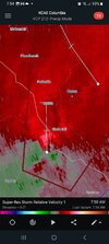
Thanks, heard reports of hail. Radar signature looked scary but I think it's tracking over the lake ATM. I am 4 miles east of modoc and it's eerily quiet.Apparently a tornado touchdown was confirmed in Columbia County a few moments ago.
Source: coworker
Recon's previous flight had it turning more northward. I will wait for this pass to see whether it has continuedIt either is or isn’t moving straight north, that is an objective fact not an opinion. Last images of eye movement someone posted here showed ne movement
It clearly shows the east impacts of the storm side that everyone should be aware.There are no doubt many weather-uninformed lurkers on weather sites at times such as this. Posting a 700Mb or even an 850Mb wind map without explanation isn't a good idea.


WhereNHS says it is rapidly intensifying.

 , like the option isn't there