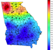
Lunchtime obs 
 (12).png")
.png")
Flagstaff, NCIf the Euro is right with 25-28c 850s mid next week rdu should challenge or break the all time record of 105.
View attachment 119206
View attachment 119207
I've said it before and I'll say it again, I hate summer fronts that make clean passages. I swear it feels like we always end up hotter on the backside than we are on the frontFlagstaff, NC
LOL,,,Yes, the problem is the KATL forecast area is massive, almost half the state since GA got jipped off by two lesser states to the E and W with multiple NWS offices. Lets look at small South Carolina, they have NWS offices and Radars in GSP< CAE and CHS. Alabama three offices and radars, HSV, BHM, and MOB. Ga, a much bigger, (area), and population has one, at KATL, and don't give the the BS that the other offices do a good job at covering the portions of GA not by KATL, because they dont. BSAnd lol at Metro Atlanta and the storms. Some things never change...
I know. I saw that too. Approached Gwinnett County and, poof, gone. Fired to the southwest, beyond Lagrange. Ouch.And lol at Metro Atlanta and the storms. Some things never change...
Not to insult you, do you think that might be the heat index???I mean this won’t verify but the 12z GFS has Atlanta getting to 106 tomorrow? Why is it so bad

You’re good. I was surprised too. Here is your proof it’s the actual tempNot to insult you, do you think that might be the heat index???

I don't know how accurate it is. 106 tomorrow in Atlanta? It won't get there if there is convection firing around the area again.You’re good. I was surprised too. Here is your proof it’s the actual temp View attachment 119212
For sure - I wasn’t saying it’s going to be accurate. I don’t think Atlanta will get over 100 tomorrow. I was more just observing that the GFS could be so far off on this particular run.I don't know how accurate it is. 106 tomorrow in Atlanta? It won't get there if there is convection firing around the area again.
that 82 on June 30 looks nice.You’re good. I was surprised too. Here is your proof it’s the actual temp View attachment 119212
Is your thinking that Atlanta won't get above 100 tomorrow because of clouds ?For sure - I wasn’t saying it’s going to be accurate. I don’t think Atlanta will get over 100 tomorrow. I was more just observing that the GFS could be so far off on this particular run.

Yeah. I think you might see 98-100 but I would surprised by anything higher before we get some clouds. But who knows! Will be fun to follow. Does seem like some of the shorter range guidance is trending warmer. NWS looks like they are going with 98-99 in the city tomorrow. Going to be miserable for sure.Is your thinking that Atlanta won't get above 100 tomorrow because of clouds ?
Correct me if I’m wrong but doesn’t the Euro have the tendency of mixing out surface dewpoints too much at this range. I mean that is showing KCLT with a high of 110 when the All-time record high is 104.If the Euro is right with 25-28c 850s mid next week rdu should challenge or break the all time record of 105.
View attachment 119206
View attachment 119207
Correct me if I’m wrong but doesn’t the Euro have the tendency of mixing out surface dewpoints too much at this range. I mean that is showing KCLT with a high of 110 when the All-time record high is 104.
I understand and what happened last year in in Seattle and Portland certainly shows what can happen if a ridge is centered just perfectly for that location… obviously that something that an operational model is probably not gonna be perfect on 7 days out.I mean we saw last year in the Pacific Northwest that the right setup can shatter all time records. 104 isn't really that high of an all-time record...Charlotte can definitely shatter that if the center of the ridge is positioned in the right way and enough heat can build at the surface.
EDIT: Not saying the Euro is right, but I wouldn't use the old all-time record as a limit for how hot it can potentially get.
This is probably the nicest excessive heat warning day I've ever experienced. 91 for the high with a DP in the upper 60s to near 70.I know you Raleigh folks thinking your temps busted, but it sure didn't here.
Seems like that leftover mcs and cloud deck only shaved 2-3 off the top. Still mid 90s.
Off to the pool I go!
With the amped up pattern we have these days it much more likely.I understand and what happened last year in in Seattle and Portland certainly shows what can happen if a ridge is centered just perfectly for that location… obviously that something that an operational model is probably not gonna be perfect on 7 days out.
Typically yeah it gets too ridgy and mixed in the piedmont post D5 and has to correct to summer climo as we get closer to verification. It may still be too low on dews but what it's spitting out regarding temps makes sense. Airmass originating from the Mexican plateau making the trek around the ridge and into our area on the NW is how we typically go 100+. If we truly realize 25-28c 850s all time records will get beaten pretty handily, I never thought I would see 110 here in my life time but I'm honestly questioning that right nowCorrect me if I’m wrong but doesn’t the Euro have the tendency of mixing out surface dewpoints too much at this range. I mean that is showing KCLT with a high of 110 when the All-time record high is 104.


Your high temps for tomorrow per the 18z GFS. If it's anything close to this tomorrow it'll be a major win as the National Blend of Models is running 5-8 degrees cooler for most locations.
View attachment 119221
The same as mid 70s in January which a lot of us have seen.Mid 90s with solid cloud cover is pretty impressive.
This heat is dead af!