Damage in Apex, some traffic lights down, lots of branches and debrisNo rain. No power. Bs
-
Hello, please take a minute to check out our awesome content, contributed by the wonderful members of our community. We hope you'll add your own thoughts and opinions by making a free account!
You are using an out of date browser. It may not display this or other websites correctly.
You should upgrade or use an alternative browser.
You should upgrade or use an alternative browser.
Pattern June 2022
- Thread starter SD
- Start date
Gusted to 8 here and lost power again.
Shaggy
Member
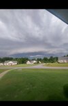
What about this oneThat looks like a legit storm inbound
Attachments
Lightning caused a woods fire near the Carolina Ale House here. My power went out for a second. Had rain, wind, and thunder but didn't actually see any lightning at my house.
Last edited:
Only .11 rain but weather station shows 42.5 mph gust, I'm not there so no idea if accurate or not. Strongest gust I've recorded since getting the Tempest so...
Shaggy
Member
I just got maybe one of the best storm.photos I've ever taken in my life. Once in a lifetime pic.
Shaggy
Member


Stormsfury
Member
Ended up being a lot less here than it looked on approach with tonight's squall line. Last nights MCS delivered more before the line began to break apart.


Lots of trees down in Wake County. Someone in Cary had a tree come down on them while they were in their car.
Wow what a day. I was out driving when the storm hit and got a good video of power flashes as tree branches were coming down. For a brief second it felt like there was no rules on the road with this thing going on. Hell of a day .. could this be classified as a derecho? Eh i dont know but it sure looks like one and It sure looks impressive! Not a tornado in sight just a damaging wind printer!
Last edited:
Downeastnc
Member
Well that was unexpected.....also dents the heatwave on the Euro especially in eastern parts of NC obviously....

Downeastnc
Member
Little bit of a temp difference in NC......

It's on the eps as wellWell that was unexpected.....also dents the heatwave on the Euro especially in eastern parts of NC obviously....
View attachment 119310

The good thing about this new cutoff is it starts soon so we should have a good idea whether or not the eps is full of it rather soon.
Downeastnc
Member
The good thing about this new cutoff is it starts soon so we should have a good idea whether or not the eps is full of it rather soon.
Yeah on a bit of a island with it.....though you can see hints of it maybe on some other models just not as defined....
While the euro and eps are backing away from the crazy heat in central nc its still a monster heat event for places south and west
.png")
BHS1975
Member
That's IF we get that upper low, otherwise we bake right along with those poor chumps.While the euro and eps are backing away from the crazy heat in central nc its still a monster heat event for places south and westView attachment 119312
View attachment 119313
BHS1975
Member
Talk about maximizing that max sun angle.While the euro and eps are backing away from the crazy heat in central nc its still a monster heat event for places south and westView attachment 119312
View attachment 119313
Yeah we would probably have mid to upper 90s Tuesday near 100 Wednesday then mid-upper 90s Thursday. The good thing is the ridge center isn't poking as far west as it was before and it starts retrograding quickly enough it would be more of a glancing intense heat shot for us vs the long duration event some locations to our SW will seeThat's IF we get that upper low, otherwise we bake right along with those poor chumps.
JHS
Member
The Raleigh NWS is not buying the cooler models for now. Forecasting highs right at 100 both Wednesday and Thursday in Wake county.That's IF we get that upper low, otherwise we bake right along with those poor chumps.
Very thankful for the rain we've had despite this intense heat.
95F is the highest so far.

95F is the highest so far.
BHS1975
Member
Might get more mcs activity.Yeah we would probably have mid to upper 90s Tuesday near 100 Wednesday then mid-upper 90s Thursday. The good thing is the ridge center isn't poking as far west as it was before and it starts retrograding quickly enough it would be more of a glancing intense heat shot for us vs the long duration event some locations to our SW will see
Iceagewhereartthou
Member
All I gotta say is, point and click now showing 57 for the low tonight; windows open baby! ?
Is this the January thread?Talk about maximizing that max sun angle.
I knew it wasn’t supposed to be this hot up here! 
gawxnative
Member
What area are you referring to? I had noticed a very "linear" looking path of damage from Just east of Loganville on US 78 in a SE Direction to Just west of Monroe on GA Hwy 138 with a "path width" of maybe a 1/4 mile .It almost looked like a tornado hit where i live yesterday multiple trees down road was blocked off pretty crazy wind
Back home from vacay and a couple of observations, the 42.5 mph wind gust the Weatherflow is showing seems erroneous as no sign of winds that magnitude here. The .68 rainfall does seem accurate as the grass is as stressed if not more so than before we left.
If the GFS is to be believed, we( me and the SE) look to improve on our drought situation!!
J1C1111
Member
50 degrees feels so good this morning after all the heat and humidity last week and more to come next week. Thats a heck of a front to get this cool toward the end of June in between these two heat waves this far south this time of year. Sure is refreshing.
57.7 here.
gawxnative
Member
Got to 59.6 here... YAY!!57.7 here.
It’s always coldest before the torch starts! ??
Fountainguy97
Member
Wow. 46.8 today. Very close or may be a daily record low.

Shaggy
Member
It's not. Both the euro and gfs from today backed sig ificsntly off those totals. Average total from them is only 1 inch for the next 2 weeks IMBYIf the GFS is to be believed, we( me and the SE) look to improve on our drought situation!!View attachment 119321
Looks like real interesting week with temps in the 103-106 degree range but dew points mixing down to the low 50’s in the day.