Storm5
Member
.

Sent from my SM-J320VPP using Tapatalk

Sent from my SM-J320VPP using Tapatalk

Looks like a good feed from the Gulf..
Sent from my SM-J320VPP using Tapatalk
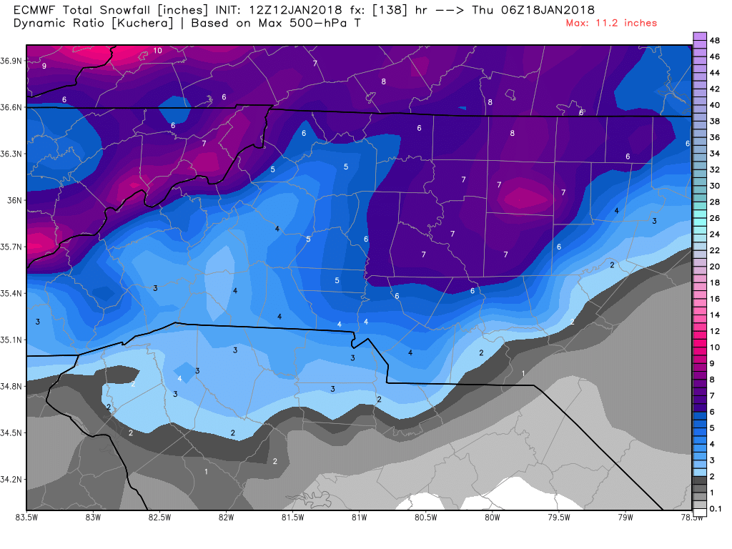
Why is there a snow hole in Birmingham ? Should it be something to worry about ?? Lol.
Sent from my SM-J320VPP using Tapatalk
I would feel a lot better about this setup if this s/w was separated from the northern stream but it's still attached all the way to the SE US coast and enters the US from MN & WI... Hard to put much trust into a weak frontal wave riding along an arctic front to spread moisture back into the Carolinas at day 5... Need another 36-48 hours before I'm very interested.
Why is there a snow hole in Birmingham ? Should it be something to worry about ?? Lol

.
Sent from my SM-J320VPP using Tapatalk

Thread time
I suggest waiting until tomorrow. Let's get the current system out and see how it effects things over the next 24 hours.Thread time
Oh its massive. Itll be 6+ on the KucheraOk not massive but still 2-4 it looks like
Sent from my SM-J320VPP using Tapatalk
an inch is massive right now. We have been so cold for so long with nothing to show for itOh its massive. Itll be 6+ on the Kuchera
New Arctic high supported by the 12Z GEFS to reach the SE 1/22. If so, that means warmup lasts no more than 2 days. Based on this, I don't think it would be premature to increase discussions on how cold this month is liable to turn out vs past cold Januaries. I'm already wondering if it will challenge 2014, which was the coldest January in KATL (6.3 colder than normal) and other areas since 1985! No, it won't be as cold as 1940 or 1977. But a top 10 percentile cold January is becoming more and more possible.
Not a lot. Important thing is for now is that we have a similar look.What are the final amounts for CAE?
Nice! Glad to hear that. Good feeling with them showing the same things.Ignore. Would have been 6-8" like the GFS depicted.
Euro is further West than the GFS with the axis of heaviest snow. You talk as though it should be further East which would benefit central NC more. Which one looks more likely in this type of scenario?Ignore. Would have been 6-8" like the GFS depicted.

Yeah, I was going to say the GFS just seemed to have a wider area covered with the higher totals.Should be a widespread area of moderate to heavy snow with that H5 solution, like the GFS depicted. We'll see if the EPS doesn't tick up again for much of the state.
The current Euro map is already correct. It has me at under an inch in the armpit of the county.If the EPS goes up across the board, it's a good sign the more widespread solution is correct.
If the EPS goes up across the board, it's a good sign the more widespread solution is correct.


No . We need you off the train it's bringing good luck . Keep taking about dry air until Monday please40 of those frames have snow here, and it's the correct time frame as well! I'm going to jump aboard this train, but I have a fear that those models with a sharp cutoff around here is a possibility. Those warm noses are pains.
LOL but I don't want to be in a snow hole. If you want bad talk, then it's going to be too dry and it's going to disintegrate. There will be no storm.No . We need you off the train it's bringing good luck . Keep taking about dry air until Monday please
Sent from my SM-J320VPP using Tapatalk