NBAcentel
Member
We’re trending to vodka level cold on almost every global/ensemble
Here’s what the ZR did to the roads later that day as she was pulling out. Ice covered roads for 5 or so days after that.First time Bausch and Lomb ever closed for snow and I had been there 11 years! Closed 2 days, think it was a Monday and Tuesday! Storm hit Sunday night, if I recall

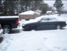
That storm was great. I was young and didn’t know anything about tracking storms but I woke up and had 2 inches of snow, sleet, and freezing rain. It’s the only time I’ve ever seen a plow have to plow our roads.Here’s what the ZR did to the roads later that day as she was pulling out. Ice covered roads for 5 or so days after that.View attachment 101792
It Can work as confluence/help with CAA !! But can also mean ots. Although that SE can block seems weird, normally you see lower heights under a -NAO off the coast not a weird SE can block, strange look
It Can work as confluence/help with CAA !! But can also mean ots. Although that SE can block seems weird, normally you see lower heights under a -NAO off the coast not a weird SE can block, strange look
The 2011 storm was epic!Here’s what the ZR did to the roads later that day as she was pulling out. Ice covered roads for 5 or so days after that.View attachment 101792


I’d almost bet that western ridge is way undermodeled with that big Aleutian low there.This is a totally workable look, need digging with that SW around the GLs, definitely far more potential in this pattern than any this winter View attachment 101812View attachment 101811
Phase that energy over Idaho and that ULL over the Baja and that is great for a one two punch with the second being a big overrunning event.We can work with this
P
Sent from my iPhone using Tapatalk

It's not good for the ol' heat pump, thats for sure! Those Aux heat strips gonna be running wild!View attachment 101787
THIS IS GOOD, RIGHT?
We ATL folks are owed this. ?

PerfectCurrent MJO: View attachment 101822


Good jobCurrently am working towards getting a map together of the snow event that ended early-mid day yesterday in NC. In the meantime, I was able to put together this map of a trace sleet event that occurred on December 21st over the SW piedmont of NC. Most of these reports are from mPING & this forum
View attachment 101821
Enjoy this while it lasts, pacific jet is going to be full scale retreat after mid-month. Only a matter of time before the -PNA comes backThat’s a great look I’d expect a better snow mean imo tho, but the overall look at H5 is there View attachment 101824
Ain’t have crap in Spartanburg. All the sleet mpings were Greenville countyCurrently am working towards getting a map together of the snow event that ended early-mid day yesterday in NC. In the meantime, I was able to put together this map of a trace sleet event that occurred on December 21st over the SW piedmont of NC. Most of these reports are from mPING & this forum
View attachment 101821
Most of that Atlanta and south is sleet and then turning to rain before ending. Still very far out and the overall pattern is all that's important right now.We ATL folks are owed this. ?
Thanks for the work you do but I can confirm none of southern Meck county saw a trace. Maybe a min of mixed sleet. No biggie just commentingCurrently am working towards getting a map together of the snow event that ended early-mid day yesterday in NC. In the meantime, I was able to put together this map of a trace sleet event that occurred on December 21st over the SW piedmont of NC. Most of these reports are from mPING & this forum
View attachment 101821
Thanks for the work you do but I can confirm none of southern Meck county saw a trace. Maybe a min of mixed sleet. No biggie just commenting
Ain’t have crap in Spartanburg. All the sleet mpings were Greenville county

Duly noted. Here's SC for the same system. Rain mixed w/ sleet near the state line in the morning hours.
View attachment 101825
I never saw that sleet in Pickens county not sure how I missed it
Sent from my iPhone using Tapatalk
I will say, I may have been hallucinating but I thought I got a couple of pingers around 6am or so. Probably hallucinatingDuly noted. Here's SC for the same system. Rain mixed w/ sleet near the state line in the morning hours.
View attachment 101825
Enjoy this while it lasts, pacific jet is going to be full scale retreat after mid-month. Only a matter of time before the -PNA comes back
That wouldn’t be surprising. In the meantime, I’m going to thoroughly enjoy the next 2 1/2 weeks or so wx wise (it is such a relief) and hope that we get another round of this starting in early or mid February even though La Niña climo doesn’t favor it. Maybe by then we can get a renewed -NAO/-AO combo along with another period of left side MJO.
You got it dudeEnjoy this while it lasts, pacific jet is going to be full scale retreat after mid-month. Only a matter of time before the -PNA comes back


So we have one around the 15th and then again 2 weeks later. Nice!Weenie 12Z CFS time: has 7 Arctic highs giving cold periods over the SE through the end of the run (Feb 5th). So, cooldowns followed by warmups etc but with no extended torchy periods, even during 1/20-2/5, which actually averages slightly BN. Plenty of Gulf/coastal Atlantic storminess including some Miller A action. IF this were to be close to reality, I don’t think there’d be too many complaints.
Here are a couple of highlights for your entertainment:
View attachment 101833
View attachment 101834