• Hello, please take a minute to check out our awesome content, contributed by the wonderful members of our community. We hope you'll add your own thoughts and opinions by making a free account!

Pattern Januworry

I am such a virgin, this is my first post......."but don't call it a comeback! I've been here for years!" ?


What I mean by that is...the very first post I made on a weather board back in Dec 2007 was on Talkweather where I barged into an ongoing thread and got into a debate with the legend himself, SD, over the ideal placement of western ridging lol, lol...which is ironic given the upcoming pattern.

Anyway, hopefully I can add to the discussion in here and not take away from it or be a distraction.

From a pattern standpoint, we've had a bit of a delay here in early Jan as the Pac Jet extension has trended stronger and farther east on the modeling. The dates I'm watching are Jan 17-18 as this is at the point where the pattern retrogrades off the E Coast a bit, and the + anomalies are at a point along the Rocky Mtn divide. I want to see how this changes over the next week (i.e. whether it moves up in time or is delayed). I don't anticipate a delay, but we'll see.

knmraxW.png


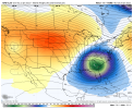
Sexy look here on Jan 19...Aleutian Low with high pressure lined up from Bismark to China

vX4avlu.png
Haha chances are you were probably right, we've come a long way in 15 years.....I think
 
I am such a virgin, this is my first post......."but don't call it a comeback! I've been here for years!" ?


What I mean by that is...the very first post I made on a weather board back in Dec 2007 was on Talkweather where I barged into an ongoing thread and got into a debate with the legend himself, SD, over the ideal placement of western ridging lol, lol...which is ironic given the upcoming pattern.

Anyway, hopefully I can add to the discussion in here and not take away from it or be a distraction.

From a pattern standpoint, we've had a bit of a delay here in early Jan as the Pac Jet extension has trended stronger and farther east on the modeling. The dates I'm watching are Jan 17-18 as this is at the point where the pattern retrogrades off the E Coast a bit, and the + anomalies are at a point along the Rocky Mtn divide. I want to see how this changes over the next week (i.e. whether it moves up in time or is delayed). I don't anticipate a delay, but we'll see.

knmraxW.png


Sexy look here on Jan 19...Aleutian Low with high pressure lined up from Bismark to China

vX4avlu.png
Please post more often. Your always welcome here!!!!! Missed your input bud.
 
I am such a virgin, this is my first post......."but don't call it a comeback! I've been here for years!" ?


What I mean by that is...the very first post I made on a weather board back in Dec 2007 was on Talkweather where I barged into an ongoing thread and got into a debate with the legend himself, SD, over the ideal placement of western ridging lol, lol...which is ironic given the upcoming pattern.

Anyway, hopefully I can add to the discussion in here and not take away from it or be a distraction.

From a pattern standpoint, we've had a bit of a delay here in early Jan as the Pac Jet extension has trended stronger and farther east on the modeling. The dates I'm watching are Jan 17-18 as this is at the point where the pattern retrogrades off the E Coast a bit, and the + anomalies are at a point along the Rocky Mtn divide. I want to see how this changes over the next week (i.e. whether it moves up in time or is delayed). I don't anticipate a delay, but we'll see.

knmraxW.png


Sexy look here on Jan 19...Aleutian Low with high pressure lined up from Bismark to China

vX4avlu.png
Welcome to the forums, grit!
 
Welcome Grit! Great to see you here and impeccable timing. If you wouldn't mind helping us turn this look into a SE snowstorm it would be greatly appreciated!

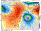
It seems like this is the timeframe to hope for a southern stream wave to meet some cold air near our latitude. Hopefully the timing can work here.

gfs-ens_z500a_nhem_50.png
 
Temps really look seasonable on the GFS which may not be a bad thing for wintery mischief.

At least that’s what I’m telling myself.

Too many times we have gotten burned by the PV shredder.


Sent from my iPhone using Tapatalk
Wait didn’t they look below normal a few hours ago lol
Welcome Grit! Great to see you here and impeccable timing. If you wouldn't mind helping us turn this look into a SE snowstorm it would be greatly appreciated!

It seems like this is the timeframe to hope for a southern stream wave to meet some cold air near our latitude. Hopefully the timing can work here.

gfs-ens_z500a_nhem_50.png
i thought yesterday we were looking at a good 2-3 week window. Now everyone is saying around the 15-17th? What gives
 
I am such a virgin, this is my first post......."but don't call it a comeback! I've been here for years!" ?


What I mean by that is...the very first post I made on a weather board back in Dec 2007 was on Talkweather where I barged into an ongoing thread and got into a debate with the legend himself, SD, over the ideal placement of western ridging lol, lol...which is ironic given the upcoming pattern.

Anyway, hopefully I can add to the discussion in here and not take away from it or be a distraction.

From a pattern standpoint, we've had a bit of a delay here in early Jan as the Pac Jet extension has trended stronger and farther east on the modeling. The dates I'm watching are Jan 17-18 as this is at the point where the pattern retrogrades off the E Coast a bit, and the + anomalies are at a point along the Rocky Mtn divide. I want to see how this changes over the next week (i.e. whether it moves up in time or is delayed). I don't anticipate a delay, but we'll see.

knmraxW.png


Sexy look here on Jan 19...Aleutian Low with high pressure lined up from Bismark to China

vX4avlu.png
You know, seems there may have been more than a couple of TW posters that got into a debate with that legendary figure @SD, ahhh the good 'ol days! Lol

Welcome aboard, we're family here, a little dysfunctional at times but family none the less. Seriously glad your here.
 
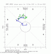
Battle of the MJOs seems like the difference in long, long range. GEFS wants to be glorious with putting us in low amp 8 and just lollygagging there. Take that Seattle!

Euro wants to just tick us all off and go, nope back to beginning of 7. IMO, the MJO has been running the show this winter. This is likely the story going into the end of the month into February. Hoping for GEFS to win this one even though La Nina etc, etc. If we can get tropical forcing into 8 and keep it there longer, the longer we avoid another western trough I think.

1641397226575.png

1641397319964.png
 
I am such a virgin, this is my first post......."but don't call it a comeback! I've been here for years!" ?


What I mean by that is...the very first post I made on a weather board back in Dec 2007 was on Talkweather where I barged into an ongoing thread and got into a debate with the legend himself, SD, over the ideal placement of western ridging lol, lol...which is ironic given the upcoming pattern.

Anyway, hopefully I can add to the discussion in here and not take away from it or be a distraction.

From a pattern standpoint, we've had a bit of a delay here in early Jan as the Pac Jet extension has trended stronger and farther east on the modeling. The dates I'm watching are Jan 17-18 as this is at the point where the pattern retrogrades off the E Coast a bit, and the + anomalies are at a point along the Rocky Mtn divide. I want to see how this changes over the next week (i.e. whether it moves up in time or is delayed). I don't anticipate a delay, but we'll see.

knmraxW.png


Sexy look here on Jan 19...Aleutian Low with high pressure lined up from Bismark to China

vX4avlu.png
The man, the myth, the legend! Welcome aboard! This is mackerel _sky from over yonder!
 
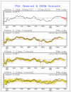
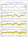
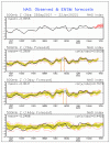
The GEFS based AO and NAO forecasts both look a bit better vs recent days late in week 2 with AO going negative and NAO falling from positive to neutral:

9A867C80-930B-4A1B-8331-48182D352FBA.gifF615E8C2-BF64-4013-86F0-A92E7859FA22.gif

The PNA is about the same as it looked recently with it finally going positive within a few days and then trending back down to neutral:

4CAFD4AA-7C8F-4513-80C8-4CCF05D812E0.gif
 
Wait didn’t they look below normal a few hours ago lol

i thought yesterday we were looking at a good 2-3 week window. Now everyone is saying around the 15-17th? What gives
The overall window of cold looks to be around at least 2-3 weeks. People are keying on the 15th-17th timeframe because that is when models really seem to be putting all the pieces together for something.
 
Battle of the MJOs seems like the difference in long, long range. GEFS wants to be glorious with putting us in low amp 8 and just lollygagging there. Take that Seattle!

Euro wants to just tick us all off and go, nope back to beginning of 7. IMO, the MJO has been running the show this winter. This is likely the story going into the end of the month into February. Hoping for GEFS to win this one even though La Nina etc, etc. If we can get tropical forcing into 8 and keep it there longer, the longer we avoid another western trough I think.

View attachment 101950

View attachment 101951
You are absolutely correct about the MJO controlling the pattern this year. The tricky part has been trying to time things with how slowly it’s been progressing. Someone can correct me if I’m wrong, but it’s seemed to me that the GEFS has overall done a better job with the MJO while it’s been going through the this slow progression.
 
Nobody is saying the 15th-17th. We look good for at least another 3 weeks right now.
Searching for SE winter weather takes time .. you need to set up the pattern to end up getting a good storm we have a great cooler than normal pattern for the next few weeks through the end of January but you have to set up for the storm signal. We’re seeing a storm signal around the 15-17 but before and even after there are signs of good cold shots that will help “marinate” the storm potential .. gotta marinate to get something delicious .. patience comes to mind as well
 
The GEFS based AO and NAO forecasts both look a bit better vs recent days late in week 2 with AO going negative and NAO falling from positive to neutral:

View attachment 101952View attachment 101953

The PNA is about the same as it looked recently with it finally going positive within a few days and then trending back down to neutral:

View attachment 101954
Interesting to see the AO looking to go negative and the NAO right about neutral at that 15th-17th timeframe that we’ve been talking about.
 
Interesting to see the AO looking to go negative and the NAO right about neutral at that 15th-17th timeframe that we’ve been talking about.
The NAO, while handsomely sporting a value of negative is more east-based in nature, based on the 500 mb charts. That's often not as helpful to us as we would want. Hopefully, it will migrate westward somewhat. That north Atlantic thumb ridge is not my favorite.
 
Back
Top