If Birmingham, AL gets snow, ATL will probably as well. Models will start to become useless for the very short range. Watching trends on radar and temps. (nowcasting) is your friend.lol she showed a model (pretty sure the HRRR at its longest range) that had ATL staying as rain through the event. She posted it as if it was a lock.
-
Hello, please take a minute to check out our awesome content, contributed by the wonderful members of our community. We hope you'll add your own thoughts and opinions by making a free account!
You are using an out of date browser. It may not display this or other websites correctly.
You should upgrade or use an alternative browser.
You should upgrade or use an alternative browser.
Wintry January 29th-30th ARCC Slam Dunk Winter Weather Threat
- Thread starter ForsythSnow
- Start date
Yeah, you're up in middle TN, right? Hopefully you get to see some flakes!I dropped from 41 to 33 over the last 50 minutes so the cold is definitely moving faster now. Most of the moisture is gone but I am getting light flurries now.
Sent from my SM-G950U using Tapatalk
Storm5
Member
Snowing in Nashville
Sent from my iPhone using Tapatalk
Sent from my iPhone using Tapatalk
Snowflowxxl
Member
FV3 was a big decrease. Alright im done looking at models. Let go
Latest from JAN:
DISCUSSION... No changes are planned to the current warning/advisory configuration. Just about all guidance continues to lock in on about a 3 hr window of significant snowfall after midnight in the current warning area as increasing ascent associated with an approaching shortwave trough expands the precipitation shield. SREF/HREF output has been showing a window of high probs for heavy snowfall rates > 1" around 07 to 08z roughly along and just north of the I-20 corridor...this period will be especially critical in determining just how heavy the snowfall ends up being. For now will maintain the 1-3 inch amounts and continue messaging for the colder air to result in icing issues toward daybreak. Guidance had been trending farther south for a while with the heaviest snowfall but this trend seems to have reversed as they get a better handle on the upstream wave/observational trends...so southern portions of the area still look on target for around an inch of snowfall, perhaps lighter based on the most recent guidance, and will maintain the advisory at this time. For northern portions of the area, the precipitation shield is fairly locked in ahead of the wave and it is a matter of waiting for sufficient cooling. It will be a close call as the rain could end before this happens, particularly along north of the Crossett to GLH/GWO corridor. Given the uncertainties prefer to maintain the advisory for now...especially given that much colder temperatures moving in could result in icing problems with residual wetness from the evening rain. /EC/
Sent from my SM-G950U using Tapatalk
Radar Scope should be utilized now if in Miss or AL
Snowflowxxl
Member
New HRRR looks great!! Ella should probably give it a look and changer her assumption for ATL smh lol
Ron Burgundy
Member
Freezing line in western TN now within about 70 miles of the precip in MS.
New HRRR looks great!! Ella should probably give it a look and changer her assumption for ATL smh lol
It's been slowly getting better on the past few runs. I see why some of you guys say HRRR is touch and go past 6hrs.


Snowflowxxl
Member
James Spann also hyping the crappy 3z HRRR run and diminishing totals. The 4z run literally went back to high totals lol. Maybe the mets should just stick with their guts and quit flipping with the models.
Snowflowxxl
Member
HRRR has souther MS getting 3 inches no to long ago and now they are down to maybe an inch. That would hurt.
addicted2boost
Member
Starting to change over in MS.
Judging by the wind directions I would think our arctic front in real time is somewhere in this general region yes?

Starting to change over in MS.
Yep

Sent from my iPhone using Tapatalk
So close! I'm catching cat naps in between checking the latest radar. TWC has my precip switching by 2 am.Yep

Sent from my iPhone using Tapatalk
Sent from my SM-G950U using Tapatalk
Precip shield now back into east TX.
Sent from my SM-G950U using Tapatalk
Sent from my SM-G950U using Tapatalk
accu35
Member
I like it when it's backup in texas, gives it time to expandPrecip shield now back into east TX.
Sent from my SM-G950U using Tapatalk
My last update before going to bed....
500mb

925mb temps

850mb temps

surface wetbulb temps

500mb
925mb temps
850mb temps
surface wetbulb temps
Snowflowxxl
Member
Heading to bed. I’ll be up at six, excited to see how it unfolds
Wts0006
Member
Raining Steady in Bluff Park Temp 53Heading to bed. I’ll be up at six, excited to see how it unfolds
StormStalker
Member
Just dropped about 7 degrees in 15 minutes here in NW Alabama.
pearidge1
Member
What is your current temp now?Just dropped about 7 degrees in 15 minutes here in NW Alabama.
JeffnTrussville
Member
Changeover occuring pretty rapidly now.

Webberweather53
Meteorologist
Webberweather53
Meteorologist
JeffnTrussville
Member

Webberweather53
Meteorologist
Definitely looks like areas just NW of Jackson, MS are changing over to snow
Webberweather53
Meteorologist
LovingGulfLows
Member
- Joined
- Jan 5, 2017
- Messages
- 1,499
- Reaction score
- 4,100
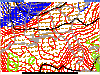
You can see the convective banding where the snow is....probably very high rates in the yellow banding.
Benholio
Member
FFC bumped up hourly temperatures around metro ATL. Here in Forsyth, time to drop below freezing has moved from 11am to 6pm. Doesn’t get below 34 during precip.
Shinrin
Member
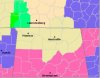
Hmm did Huntsville cancel their winter storm waring?
pearidge1
Member
Hmm did Huntsville cancel their winter storm waring?
Not showing up on the interactive map on their site any longer.
Attachments
HSVweather
Member
http://www.waff.com/2019/01/29/first-alert-weather-day-winter-storm-warning-cancelled/Not showing up on the interactive map on their site any longer.
HSVweather
Member
alabamawx just posted an update as well
https://www.alabamawx.com/?p=182222
https://www.alabamawx.com/?p=182222
Shinrin
Member
Seems Birmingham just moved us to a WWA
HSVweather
Member
All of HSV CWA going to winter weather advisory. Birmingham and points south and west down 20/59 still winter storm warningSeems Birmingham just moved us to a WWA
Seeing a lot of mention of "back edge of precip" and "cold air moving in slower than forecast" across different offices such as Huntsville and Shreveport.
HSV basically said that the 00z NAM was the only reason they didn't make bigger changes earlier.
HSV basically said that the 00z NAM was the only reason they didn't make bigger changes earlier.
WarEagle22
Member
Yeah...not liking that update. Confused though b/c at my location, I though the current temps were pretty on par with the forecast temps at this time and that we would drop quickly once the colder air arrived (which was to be later). We were just removed over here from the WSW. Oh well, on to next winter.
Was always concerned that the colder air wouldn't be here fast enough though. We were really threading the needle on this one.
Was always concerned that the colder air wouldn't be here fast enough though. We were really threading the needle on this one.
Phil Connors
Member
The dude who posted on spanns blog didn’t mention the fact that once heavier rates start in Bham the column cools rapidly. Just that “cold wasn’t catching up” curious update at this point given that there are still at least 2 or 3 hours of moderate precipitation to south and west- I’ve seen 850s crash and Lower temps in a matter of minutes.
Sent from my iPhone using Tapatalk
Sent from my iPhone using Tapatalk