SREF goes down, NAM goes up in snow totals. Helter skelter to the last moment.
-
Hello, please take a minute to check out our awesome content, contributed by the wonderful members of our community. We hope you'll add your own thoughts and opinions by making a free account!
You are using an out of date browser. It may not display this or other websites correctly.
You should upgrade or use an alternative browser.
You should upgrade or use an alternative browser.
Wintry January 29th-30th ARCC Slam Dunk Winter Weather Threat
- Thread starter ForsythSnow
- Start date
LovingGulfLows
Member
- Joined
- Jan 5, 2017
- Messages
- 1,499
- Reaction score
- 4,100
3km NAM looks impressive for Alabama and NW GA.
Jean-Claude Van Nam
Member
This storm is riding I-59 in Bama from Gadsden to Boligee. Almost looks 20 miles either side for best totals.
NAM 3km has Atlanta getting snow.
LovingGulfLows
Member
- Joined
- Jan 5, 2017
- Messages
- 1,499
- Reaction score
- 4,100
3km actually gives some parts of Atlanta heavy snow towards the end at hour 16. Interestng.

Sheesh at that updraft helicity. No doubt an EF3 or two if those supercells verify.
NBAcentel
Member
Hope..... no this is not a joke 
WXinCanton
Member
look at those hooks!Sheesh at that updraft helicity. No doubt an EF3 or two if those supercells verify.
That would be the heaviest snow I’ve ever seen if it verifies!


3km actually gives some parts of Atlanta heavy snow towards the end at hour 16. Interestng.
00z NAM is illustrating that worst case scenario from the snow uncertainty graphic FFC put together earlier today. This was one of their concerns that ATL south and west could get hammered from a band just like this.
HRRR was wetter but didn't give Atlanta any snow.
I just got to Clinton, MS. I may get very little sleep tonight, since the action gets going after 1 am. Temp is about 55 out here and breezy. No precip yet.
Sent from my SM-G950U using Tapatalk
Sent from my SM-G950U using Tapatalk
Snowflowxxl
Member
Just saw the NAM. Intrigued. As much as I usually mock it, this is truly gonna be a nowcast situation.
I suppose it's Battle stations funny so far most all recent model runs have done an abrupt 180 and trended up for some pretty decent areas of impact. We got the RAP, 12KNAM, 3KNAM, HRRR, WRF-AR, and WRF-NM both appear to on the uptick as well, which is nice but at sometime its radar and SPC watching now too
Stormlover
Member
The same ensemble of models that said 100% chance of at least an inch for Huntsville last night, and an average of 3.03 inches, now says .68 of an inch of snowfall on average here. Yeah, I"m not happy.
Jean-Claude Van Nam
Member
Snowflowxxl
Member
We tried to tell you that the SREF was unreliable. Hope it works out for you.The same ensemble of models that said 100% chance of at least an inch for Huntsville last night, and an average of 3.03 inches, now says .68 of an inch of snowfall on average here. Yeah, I"m not happy.
Darklordsuperstorm
Member
That band should be rocking wonder if we might get some thundersnow out of it ?
Stormlover
Member
well, most all models have moved south and/or east and lowered amounts in this area...some just did it sooner, lolWe tried to tell you that the SREF was unreliable. Hope it works out for you.
Woah!!

NBAcentel
Member
Definitely a thunder snow sounding to me
Stormlover
Member
hmm.. from someone on facebook that has done meteorology in the service:
Here is a quick analysis of the current water vapor satellite shot. All of the players that could bring snow to the south are visible. Those east of AR need that vorticity lobe over Oklahoma to arrive on schedule early a.m. Any delay in this will delay onset of snow. This feature will bring the forcing that is going to be necessary in the mid-levels of the atmosphere. Without this, the dendritic growth zone likely fails overall in production.
A jet streak down at 500mb is seen over Texas with a small maximum which also will aid in lift if it arrives on time as well.
All of this has to Merry up at the right time for good enough snow production to overcome melting affects of very warm ground (ground temps in the mid 50s). That will cut totals ..but by how much? Will find out tomorrow.
Boy would I be ill. Two to five miles from three inches while I'd get a spittle. Haha
weatherguy
Member
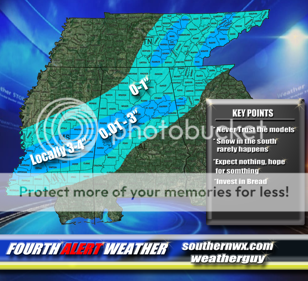
My last call:
Last edited:
FFC:
.UPDATE...
Current forecast is on track tonight as clouds push across the
area and light rain is entering northwest Georgia. Have only made
minor tweaks to hourly temperatures and sky cover at this time.
Have not made any changes to the Winter Weather Advisory or Watch
at this time, as we will continue to monitor incoming model data.
Updated forecasts issued shortly.
AL/TN Line
Member
- Joined
- Dec 29, 2016
- Messages
- 8
- Reaction score
- 19
Huntsville updated at 8:57...... kept winter storm warning and 1-3 inches of snow.
Should be interesting tomorrow evening.... let's see if any of these 3" lollipops verify

NBAcentel
Member
Lol looks like trying to find where you will get a downburst/heavy t-storm In the summer
Update
925mb temps

850mb temps

Current Surface

925mb temps
850mb temps
Current Surface
Yeah good to see a model other than just the FV3 give central NC a shot at more than token flurries. These convective shots are quite unpredictable but fun if you’re lucky enough to be underneath it.Should be interesting tomorrow evening.... let's see if any of these 3" lollipops verify
Snowflowxxl
Member
RGEM is up for GA. Has the west metro over an inch for the first time.
Let's just hope one of us on here who really love this stuff is one of the lucky one's LolYeah good to see a model other than just the FV3 give central NC a shot at more than token flurries. These convective shots are quite unpredictable but fun if you’re lucky enough to be underneath it.
00z RGEM - Holding about steady to 18z, it's even a little bit slower on the backend vs 18z.


RGEM all rain for NC except for mountains, stinks but seems about right considering those mountains will probably delay CAA
Stormlover
Member
This is an official prediction just out...holding more snow in places the models don't show it.
NBAcentel
Member
hrrr looks horrible aswell for nc, nam is probably overdone/to cold
Most everybody west of the apps, we need this system to have PTSD...
P-IVOT
T-ILT
S-LOW
D-IG
P-IVOT
T-ILT
S-LOW
D-IG
Kylo
Member
18z Euro. Let’s see how it verifies


Storm5
Member
Lol the short range models look good now and the gfs goes to s###
Sent from my iPhone using Tapatalk
Sent from my iPhone using Tapatalk