accu35
Member
Maybe a fast mover, but 1-3 inch for me is goldI'm sure you're not the only one wishing for that. But, it's not going to slow down. It's going to be a fast mover for sure.
Maybe a fast mover, but 1-3 inch for me is goldI'm sure you're not the only one wishing for that. But, it's not going to slow down. It's going to be a fast mover for sure.
I doubt the cold will be delayed, because it's a true arctic blast. Some area's may start off as rain, but quickly changing to all snow.Is it at all possible that the cold air gets delayed a bit and this ends up being primarily a rain event? Or is the snow pretty much a lock at this point?


That’s what I am saying. I guess there so much energy in this system it just keeps it going?? Maybe??This thing was really close to something big. Good run for many. Whew, very very close to being a crushjob scenario across the board scenario.
This thing was really close to something big. Good run for many. Whew, very very close to being a crushjob scenario across the board.
Sure was, another trend like that and we have a Miller A on our hands.
Yea, I defitnely feel a lot better about this system bringing the goods for many.The snow accumulation maps will probably look limited the further East.. into GA/SC/NC but now I'm officially excited to see what 12z brings!
Well I guess Dr. No has spoken. I would had thought it would turn out better.
It looks like the mountains squeezed out whatever remaining moisture there was left.Well I guess Dr. No has spoken. I would had thought it would turn out better.


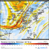
This will go back and forth some until the actual event. Even through the precip map says it is snow. It probably accumulated in the computer as rain. Plus at time stamp it has temps between 32-35 degrees so that might be also why it doesn’t show up as accumulated snow.Someone explain the accumulated map around BHAM?
View attachment 13160View attachment 13161View attachment 13162View attachment 13163
Someone explain the accumulated map around BHAM?
View attachment 13160View attachment 13161View attachment 13162View attachment 13163
Anyone else would like to chime in???That's a mess. Might as well toss that Euro run. No way it sorts that out yet.

I’m not sure the last time I saw a euro run the basically plastered all of Tennessee with at least 3 inches of snow. Very good run for the mid State no doubt. I mean the whole state. LolGreat Euro run for Tennessee, N Miss, and N Alabama.
Is it tapping the gulf ?Anyone else would like to chime in??? View attachment 13166
The Euro definitely was kinda weird at H5 compared to other model guidance.Anyone else would like to chime in??? View attachment 13166