Decent amount and its slick. It will be a nightmare in the AM as whatever is on the surfaces will ice over,How much glazing on surfaces?
-
Hello, please take a minute to check out our awesome content, contributed by the wonderful members of our community. We hope you'll add your own thoughts and opinions by making a free account!
You are using an out of date browser. It may not display this or other websites correctly.
You should upgrade or use an alternative browser.
You should upgrade or use an alternative browser.
Wintry January 14-16th storm potential.
- Thread starter TheBatman
- Start date
Hootchiekoo
Member
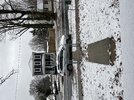
Happy for everyone getting good snow out of this. Hardly anything happening in Huntsville at the moment, back to very light sleet showers. The temperature does continue to drop however, down to 22/19 here.In Rogersville. Heavy bursts of snow the change back to sleet quickly. 19 here now with a steady sleet shower. The snow is a dry fluffy powder and sleet is small hard frozen so it has ample time/depth to freeze solidly.
Hootchiekoo
Member
Yes we got in on that too. It snowed heavy for about 20 minutes.We’re getting some bigger heavier snow now. Still some sleet mixing though. Probably the hardest it’s snowed the entire event.
W
WSW
Guest
Rt 33 North Fork Mountain. West of Franklin WV. Elevation 3580.

I hung around 34 for a long time but have gone all the way to 39. Not sure if it is the ridge or just solar. I have a feeling when the sun goes down the front will start pushing south.It really is. We have a full proof cold weather shield in place. I’m interested to see if if actually moves when it is supposed to. I feel like it’s actually gone north some today.
This was the 3kNAM at 18z yesterday for highs this afternoon:I hung around 34 for a long time but have gone all the way to 39. Not sure if it is the ridge or just solar. I have a feeling when the sun goes down the front will start pushing south.

This is what we have currently:


SnowwxAtl
Member
Well, I am under a Winter Weather Advisory now for ice.. Light glaze expected!
BHAMWX
Member
.25 is when it can get bad ?
Here is the updated map.Well, I am under a Winter Weather Advisory now for ice.. Light glaze expected!


I was just about to post this. Could be bad on the roads tomorrow morning.
Darklordsuperstorm
Member
That's bordering on ice storm warning criteria
accu35
Member
 I can smell a criteria warning soon
Little over 1" of cement here, roads drivable but very slushy. Mostly sleet again now, 31.1 degrees
ChattaVOL
Member
Little over 1" of cement here, roads drivable but very slushy. Mostly sleet again now, 31.1 degrees
Roads are going to be a mess tonight.
Sent from my iPhone using Tapatalk
BHAMWX
Member
So a last minute change in the forecast as with past winter events ?View attachment 142517I can smell a criteria warning soon
That is .31 swath from Birmingham to Gadsden, they would have to. That would be huge.View attachment 142517I can smell a criteria warning soon
Iceagewhereartthou
Member
46 this am
It takes a pretty special model to bust low AND high at the same time.?This was the 3kNAM at 18z yesterday for highs this afternoon:
View attachment 142510
This is what we have currently:
View attachment 142511
Darklordsuperstorm
Member
Yep you're starting to talk about power outages at that pointThat is .31 swath from Birmingham to Gadsden, they would have to. That would be huge.
hashslingingslasher256
Member
Can’t remember my last ice storm here in Gadsden. Is there any way for this to fall as anything other than freezing rain? Worried about power outages. We are 100% electric
Webberweather53
Meteorologist
Yet another classic case of melting-induced frontogenesis near the rain-snow line over southern TN today.
Advancing low-mid level warm advection is partially offset by melting snow aloft near the rain-snow line.
This causes the local temperature gradient to increase, enhancing local frontogenesis & ascent, leading to higher snowfall rates and larger dendrites near and just to the cold side of the rain-snow line.
I've always had a soft spot for overrunning events like this for this very reason. It's hard for models to sniff out subtle warm advection aloft like this. Furthermore, the aforementioned secondary latent heating (absorption) feedbacks associated with this warm advection lead to even greater increases in precipitation &/or snowfall rates, particularly in a narrow band close to the rain-snow line. It's a beautiful thing to watch unfold in real time.
It comes down to timing. How much of the moisture is left when it gets to freezing. From what the models are showing, there will be freezing rain and a mix. Now we wait to see how much.Can’t remember my last ice storm here in Gadsden. Is there any way for this to fall as anything other than freezing rain? Worried about power outages. We are 100% electric
olhausen
Member
We going for 7 possibly. Last measure was an hour ago and was almost 6 inches. I’ve never had the globals be this off for my area. I guess sub 10 degrees and precipitation go good together.

ColdCoreLow
Member
The top 2 rows of counties under WWA in central AL may need an ice storm warningView attachment 142517I can smell a criteria warning soon
AlabamaWxWatcher
Member
Looks like the winter storm warnings got pulled south in MS?
W
WSW
Guest
Still coming down in Tazewell VA.

olhausen
Member

Stormlover
Member
GFS Wed morning

Where’s Tennesseestorm?? I miss his it never snows and gets cold in the south! Hope he’s out tornado chasing!?
Storm5
Member
Yeah Jackson upgraded for a lot of their area mainly due to impacts of iceLooks like the winter storm warnings got pulled south in MS?
HugeSnowStick
Member
That is a clown map, If I have even seen one.GFS Wed morning
LickWx
Member
No it’s pretty plausible. Snow pack and clear night with no wind…. Yucky weather . Anyone with camellias or azaleas or even crepe myrtle can say goodbye to their plants! Gon look like a tundra out there till AprilThat is a clown map, If I have even seen one.
Stormlover
Member
Might be a little low, but it's no clown mapThat is a clown map, If I have even seen one.

I drove up to the AL Tennessee border north of Huntsville about an hour ago. Some of the biggest flakes I’ve ever seen. Pancakes. Extremely high rates and then sleet started to mix back in and takeover even there. About 3 inches in the ground.Yet another classic case of melting-induced frontogenesis near the rain-snow line over southern TN today.
Advancing low-mid level warm advection is partially offset by melting snow aloft near the rain-snow line.
This causes the local temperature gradient to increase, enhancing local frontogenesis & ascent, leading to higher snowfall rates and larger dendrites near and just to the cold side of the rain-snow line.
I've always had a soft spot for overrunning events like this for this very reason. It's hard for models to sniff out subtle warm advection aloft like this. Furthermore, the aforementioned secondary latent heating (absorption) feedbacks associated with this warm advection lead to even greater increases in precipitation &/or snowfall rates, particularly in a narrow band close to the rain-snow line. It's a beautiful thing to watch unfold in real time.
Those first few counties that stayed all snow up there have a legit shot at half a foot I imagine.
HugeSnowStick
Member
I feel an Ice Storm in parts of Atlanta Metro late tonight, tomorrow.
olhausen
Member
It’s been 10-12 degrees all day today. Heavy snow and no wind is going to help Temps drop.That is a clown map, If I have even seen one.
Nerman
Member
Not gonna get cold enough, fast enough. Not to mention these ground Temps when it's out here feeling like Spring Break today.I feel an Ice Storm in parts of Atlanta Metro late tonight, tomorrow.
olhausen
Member
He’ll be back in 2 weeks when temps are above normal talking about how it doesn’t snow like it use to ?Where’s Tennesseestorm?? I miss his it never snows and gets cold in the south! Hope he’s out tornado chasing!?