Chattownsnow
Member
Interestingly here just north of Chattanooga we have remained all snow so far after light sleet to start out around 830am
That's getting lose to causing some problems as in some places the acrual will be rather high given Temps in the 20s and light, persistent precip.

Consider the source. I watched a MSM channel last night with a reporter out in the cold saying it’s snowing in places that never get snow like Memphis and Dallas like it’s the end of times. This is clearly a normal winter event and was being made into an earth ending climate change catastrophe. It’s just winter folks and weather patterns are cyclical.Weather channel is showing Memphis has received 17 inches the past 24 hrs that can’t be right?? I’ve seen videos looks like maybe 4-6 inches. Is their system very inaccurate or something?

Snowing hard hereI hope this next batch coming out of MS is more snow than sleet. We have been battling mixing issues this morning. Back and forth.
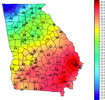
you do realize the stuff for much of Ga is overnight into Am Tuesday. Right?The temp gradient from Nashville to Atlanta is ridiculous.
You don't have to go very far west or north to get snow.Starting as sleet in Richmond ?

Just under 1" of qpf on the latestv hrrr and rap for Chattanooga and Knoxville. Not going to matter if that's sleet, snow, or a mix of both. That's a lot of frozen precip for any winter storm.
Still to come? Or storm total?
Sent from my iPhone using Tapatalk
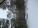
We've pushed over 3" up in Signal Mountain. It's been more sleet than snow for the past 45 minutes but still waffling. Models have been depicting a little cooling in the 850's this afternoon. Hopefully that'll keep us both primarily snow later on.Just under 1" of qpf on the latestv hrrr and rap for Chattanooga and Knoxville. Not going to matter if that's sleet, snow, or a mix of both. That's a lot of frozen precip for any winter storm.
More water content
an inch,if its snows like this for a few hours think we get bout 2 or 3 moreUp to 5 inches now. Hoping to squire out another inch